Tourist trails
A new definition of maps of hiking trails.
Thanks to the application you can:
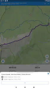
◾ Designate and plan hiking on and off mountain trails
◾ Find out the elevation gain, distance and time of the route
◾ Save planned routes "for later"
◾ Share planned and already traveled routes with friends
◾ Record your trips and see how many calories you've burned and lost weight
◾ Mark routes as traveled
◾ Import routes from Apple Fitness (HealthKit), Strava or GPX file
◾ Track your friends' activities and send them the routes you have traveled together
◾ Download offline maps of popular regions to feel safe on the trail even when there is no internet (premium)
◾ View the most traveled trails and starting points on the map layer (premium)
◾ View the routes you have already traveled on the map layer (premium)
◾ Track your stats and those of others, such as: summits climbed by mountain range, number of activities, distance covered, ascents and calories burned on an annual and overall basis (partially in premium)
◾ Collect conquered peaks and track your progress in popular mountain crowns, e.g. in the "Crown of the Polish Mountains", "Diadem of the Polish Mountains", "Tourist Crown of the Tatra Mountains", "Crown of the Island Beskids", etc. (partly in premium)
The map area includes Poland, Czech Republic and Slovakia.
Map of mountain trails includes e.g. mountain ranges:
◾ Makowski Beskids
◾ Beskid Mały
◾ Low Beskids
◾ Beskid Sądecki
◾ Silesian Beskids
◾ Silesian-Moravian Beskids
◾ Island Beskids
◾ Zywiecki Beskids
◾ Bieszczady
◾ Hot
◾ Bardzkie Mountains
◾ Bystrzyckie Mountains
◾ Eagle Mountains
◾ Jizera Mountains
◾ Kaczawskie Mountains
◾ Stone Mountains
◾ Opawskie Mountains
◾ Owl Mountains
◾ Table Mountains
◾ Wałbrzyskie Mountains
◾ Golden Mountains
◾ Bialskie Mountains
◾ Giant Mountains
◾ Pieniny
◾ Tatra Mountains
Show More


