Census | Public Lighting Survey
With this preview page, we want to present the App, the result of painstaking work also carried out in the field. By using this application we have surveyed the entire territory of a Sicilian municipality having about 1500 points in just two days!
With our application it will be possible to carry out censuses and complete surveys for public lighting systems.
CenCity allows the operator to enter all the data to be stored in a specially designed database in order to have a comprehensive global view of the entire IP system.
The application is intuitive and fast, we have tried to make all the APP functions at your fingertips for a better user experience.
CenCity: Strengths
Here are the strengths of CenCity:
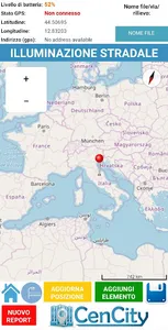
- GPS position (also with external Bluetooth GPS);
- Location address (street and house number);
- Manual refinement of the position of the detected device (when the GPS does not - provide an exact position);
- Data entry speed (with the possibility of pre-loading data from various models or copying data from the previous entry);
Census | Public lighting survey: detectable data
By using our App for the Census of poles and public lighting fixtures, the following data can be collected:
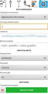
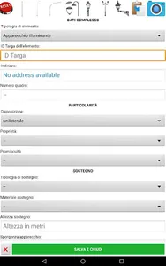
- Electrical panel number to which the appliance belongs;
- Disposition: if unilateral, bilateral, etc .;
- Ownership: whether municipal or otherwise;
- Promiscuity: electrical or mechanical;
- Type of support: if straight pole, curved pole, arm, bracket, etc .;
- Support material: steel, galvanized iron, cast iron, etc .;
- Height of the support;
- Protrusion of the appliance;
- Data on the power supply line;
- Presence of wells, earth or terminal blocks;
- And so much more…
With CenCity, after the survey it is possible to export the data in the following formats:
- CSV files, which can be opened and processed in Excel. This file will contain all the data including GPS address and position;
- KMZ files that can be opened with Google Earth and view the markers and related data.
After export, using a guide provided by us, it is possible to convert the data into a DWG file containing the geo-referenced objects and related data.
With this preview page, we want to present the App, the result of painstaking work also carried out in the field. By using this application we have surveyed the entire territory of a Sicilian municipality having about 1500 points in just two days!
With our application it will be possible to carry out censuses and complete surveys for public lighting systems.
CenCity allows the operator to enter all the data to be stored in a specially designed database in order to have a comprehensive global view of the entire IP system.
The application is intuitive and fast, we have tried to make all the APP functions at your fingertips for a better user experience.
CenCity: Strengths
Here are the strengths of CenCity:
- GPS position (also with external Bluetooth GPS);
- Location address (street and house number);
- Manual refinement of the position of the detected device (when the GPS does not - provide an exact position);
- Data entry speed (with the possibility of pre-loading data from various models or copying data from the previous entry);
Census | Public lighting survey: detectable data
By using our App for the Census of poles and public lighting fixtures, the following data can be collected:
- Electrical panel number to which the appliance belongs;
- Disposition: if unilateral, bilateral, etc .;
- Ownership: whether municipal or otherwise;
- Promiscuity: electrical or mechanical;
- Type of support: if straight pole, curved pole, arm, bracket, etc .;
- Support material: steel, galvanized iron, cast iron, etc .;
- Height of the support;
- Protrusion of the appliance;
- Data on the power supply line;
- Presence of wells, earth or terminal blocks;
- And so much more…
With CenCity, after the survey it is possible to export the data in the following formats:
- CSV files, which can be opened and processed in Excel. This file will contain all the data including GPS address and position;
- KMZ files that can be opened with Google Earth and view the markers and related data.
After export, using a guide provided by us, it is possible to convert the data into a DWG file containing the geo-referenced objects and related data.
Show More