The PRS II Cerrado Project has as main objectives to mitigate greenhouse gas (GHG) emissions and increase the income of small and medium producers in the Cerrado biome, by promoting the adoption of technologies low carbon footprint. The activities focus on the implementation of integrated crop-livestock-forest (ILPF) systems and the recovery of degraded pastures (RPD), aiming to contribute to sustainable rural development in the Cerrado, increasing land use efficiency, productivity and increasing in generating income among producers, mitigating GHG emissions and reducing the pressure to clear native forest for agricultural production. The project operates in the states of Goiás, Mato Grosso, Mato Grosso do Sul and Minas Gerais, in municipalities that have a significant percentage of degraded pastures, high rates of deforestation and aptitude for the introduction of integrated production systems.
In line with these demands, the AgroTag System was proposed in one of the activities of the sub-project 'Development and Validation of an MRV system for ABC Agriculture applied to the Sustainable Rural Project II' as a tool to support actions to monitor rural properties with technologies sustainable and diverse production systems. The AgroTag has already been discussed as part of a Monitoring, Reporting and Verification (MRV) strategy for Greenhouse Gas Emissions from Low Carbon Agriculture due to its characteristics of traceability of information collected in the field, also allowing the crossing of these information based on geospatial data and monitoring of areas by satellite images.
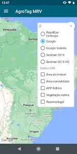
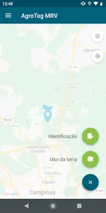
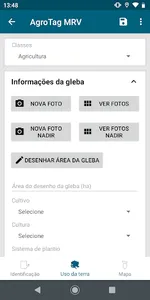
In the customized version of AgroTag in PRS II Cerrado, called AgroTagMRV, the data collected in the field with the app are automatically associated with the polygons of the Rural Environmental Registry (CAR) in WebGis, enabling the monitoring of agricultural actions since the implementation of activities, generating a robust database of information and georeferenced photos with the history of land use and management used in the rural property. Additionally, AgroTagMRV incorporated calculations used in the GHG Protocol Agropecuário tool, providing the carbon balance of the main agricultural activities of the rural property. Being validated as part of an MRV proposal in these areas of the Cerrado, AgroTagMRV has the potential to be used in any region of the Brazilian territory, like other modules of the AgroTag System.
In line with these demands, the AgroTag System was proposed in one of the activities of the sub-project 'Development and Validation of an MRV system for ABC Agriculture applied to the Sustainable Rural Project II' as a tool to support actions to monitor rural properties with technologies sustainable and diverse production systems. The AgroTag has already been discussed as part of a Monitoring, Reporting and Verification (MRV) strategy for Greenhouse Gas Emissions from Low Carbon Agriculture due to its characteristics of traceability of information collected in the field, also allowing the crossing of these information based on geospatial data and monitoring of areas by satellite images.
In the customized version of AgroTag in PRS II Cerrado, called AgroTagMRV, the data collected in the field with the app are automatically associated with the polygons of the Rural Environmental Registry (CAR) in WebGis, enabling the monitoring of agricultural actions since the implementation of activities, generating a robust database of information and georeferenced photos with the history of land use and management used in the rural property. Additionally, AgroTagMRV incorporated calculations used in the GHG Protocol Agropecuário tool, providing the carbon balance of the main agricultural activities of the rural property. Being validated as part of an MRV proposal in these areas of the Cerrado, AgroTagMRV has the potential to be used in any region of the Brazilian territory, like other modules of the AgroTag System.
Show More