This augmented reality app is part of an art project by Mona Young-Eun Kim, which takes place in Montpellier, France. It seeks to project information into digital space and disrupt visual information in the real world.
main Features
Discover the linguistic information hidden in the gallery
Find photo bubbles in the city
Scan all city image targets to hack the world
Permissions
Requires permission for camera access for augmented reality support
Requires authorization for GPS location data for AR + GPS support and to place prefabs in the world.
Instructional scene
Shows users the main functions of the app and how to use the app
Stage service conditions
Displays the terms and conditions of use of the application.
Contains the contact details of the artist developer.
Gallery scene
Access the device's camera for an AR view.
Scanning the target images in the gallery will cause information to appear on the panels around the gallery space.
Choosing the different language scenes will change the language that appears when the target images are scanned.
Street scene
Access the device's camera for an AR view.
This scene uses the device's GPS data to place 360 image bubbles in the environment for the viewer to navigate and find in the city.
The user can scan image targets around town taken from signs and store facades to activate various blur effects and remove visual information around them.
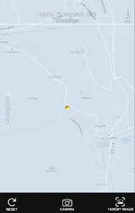
Map scene
Users can click on the map pins to see the location of the photo bubbles in the city
Users can click on the name of the location to open a Google Maps page with directions to the different locations
Target scene of the image
Users can see which signs and facades are the image targets that activate the blur effects in the street scene.
main Features
Discover the linguistic information hidden in the gallery
Find photo bubbles in the city
Scan all city image targets to hack the world
Permissions
Requires permission for camera access for augmented reality support
Requires authorization for GPS location data for AR + GPS support and to place prefabs in the world.
Instructional scene
Shows users the main functions of the app and how to use the app
Stage service conditions
Displays the terms and conditions of use of the application.
Contains the contact details of the artist developer.
Gallery scene
Access the device's camera for an AR view.
Scanning the target images in the gallery will cause information to appear on the panels around the gallery space.
Choosing the different language scenes will change the language that appears when the target images are scanned.
Street scene
Access the device's camera for an AR view.
This scene uses the device's GPS data to place 360 image bubbles in the environment for the viewer to navigate and find in the city.
The user can scan image targets around town taken from signs and store facades to activate various blur effects and remove visual information around them.
Map scene
Users can click on the map pins to see the location of the photo bubbles in the city
Users can click on the name of the location to open a Google Maps page with directions to the different locations
Target scene of the image
Users can see which signs and facades are the image targets that activate the blur effects in the street scene.
Show More