About HydroMapSylt
The HydroMapSylt is an initiative of the company Hako Design, whose owner is a passionate firefighter and who has taken on the task of digitizing fire departments in the core and so for firefighters 1.1.2 future well to set-up.
About Hako Style:
Applications for firefighters - are a labor of love for uns.Bei our product ideas we did not focus ourselves from Hako design solely to the website operator. Especially for fire services in Schleswig Holstein our (corporate) heart beats.
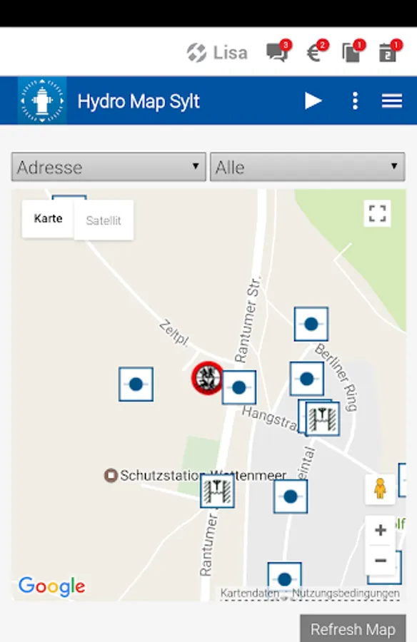
The HydroMapSylt is a surface for the volunteers Feuerwehrfrauen- and men on Sylt which you can locate all water intakes on Sylt. Using GPS signal of your terminal is determined your site and you are on a digital map of the surrounding water points such as Hydrants or wells indicated by symbols according to DIN 14034-6. A navigation function is intigriert that allows external emergency services to be navigated directly to a previously selected water intake point.
"You have reached your destination"
this application is topped by the representation of the surface drainage on Sylt, the at e.g. Oil or hazardous material accidents quick decisions for example, Close of surface drainage facilities can support to protect the environment.
About Hako Style:
Applications for firefighters - are a labor of love for uns.Bei our product ideas we did not focus ourselves from Hako design solely to the website operator. Especially for fire services in Schleswig Holstein our (corporate) heart beats.
The HydroMapSylt is a surface for the volunteers Feuerwehrfrauen- and men on Sylt which you can locate all water intakes on Sylt. Using GPS signal of your terminal is determined your site and you are on a digital map of the surrounding water points such as Hydrants or wells indicated by symbols according to DIN 14034-6. A navigation function is intigriert that allows external emergency services to be navigated directly to a previously selected water intake point.
"You have reached your destination"
this application is topped by the representation of the surface drainage on Sylt, the at e.g. Oil or hazardous material accidents quick decisions for example, Close of surface drainage facilities can support to protect the environment.