"Kanyu Transparent Compass" is a tool for measuring orientation on "maps" and "building floor plans". It provides a variety of vertical ruler disk surfaces, just like a transparent compass, which can be set on one drawing surface to facilitate orientation measurement and Fengshui identification.
Basic operation:
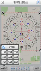
1. Add a new file.
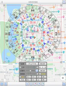
2. Press the bottom right button to get the base map.
3. Adjust the degrees of the "Pole Ruler" and "Cross Line" from the bottom to match the orientation of the house on the base map. (Note: When using the map, the azimuth will be automatically set to the sub-direction of Wushan Mountain, just adjust the direction of the crosshairs.)
4. Move the pole ruler to the position you want to measure.
The pole plate provides:
8 grids. Luoshu. Hexagram symbols. 24 mountains
8 grids. 24 hills
24 grids. 24 mountains
●Gossip. 8 grids. No scale
●Gossip. 8 grids
●12 grids. 12 earthly branches
●Mysterious Empty Disk
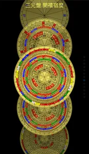
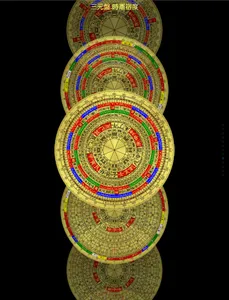
●Three Yuan Plate. Kaixi Sudu
●Three-Yuan Plate. Time Xian Sudu
●Three-in-one plate. Kaixi Sudu
●Three-in-one disk.
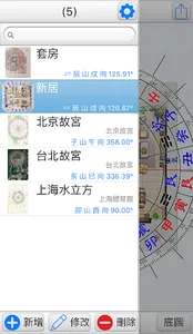
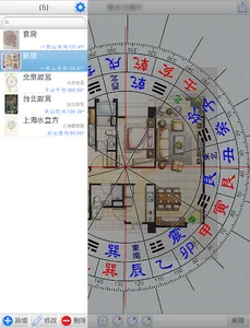
File management: (provide file management, thumbnail preview, easy to manage all the files that have been operated)
●Add new file: Please click "Add" first, and then start the operation of the vertical ruler set.
●Modify file: modify the project name of the file.
●Delete file: After selecting a file, click "Delete" to delete the file.
●File list: Provide information such as thumbnails of the actual set of maps, project names, addresses (can be used to search for maps), seating orientation, and seating degrees.
●Quick Search: Enter text in the upper search bar to find files containing the text in the project name and address.
●Provide Google cloud backup and data recovery function by Google (backup includes package files and settings).
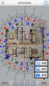
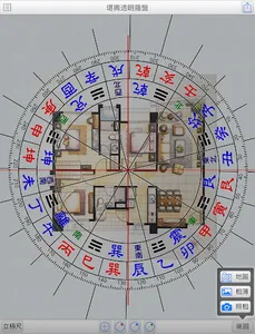
Basemap:
●Map: Capture the map and use it as a base map, which can be displayed in three modes: normal, satellite, and hybrid, and can be searched by entering an address (can be recorded in the current file).
●Album: Select photos from the album and use it as a base map.
●Photography: Through the camera function, take a photo and use it as a base map.
●Edit: Editable cropping and rotating basemap.
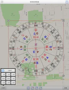
Center positioning:
●Purpose: To provide the center position of a certain area of the survey base map.
●Style: Three styles are available: "cross, nine-square grid, and 7x7 grid".
●Fixed display: Check to keep the display all the time, and the status record can be archived.
●The operation method is as follows:
●Place and align the distance shape on a certain area of the base map.
●The distance shape can be stretched, contracted and rotated arbitrarily.
●Press "Place Pole at Center" to place the pole at the center.
●Note: The rotation angle here has nothing to do with the pole ruler, the main purpose of the rotation is to align the base map.
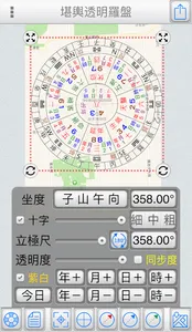
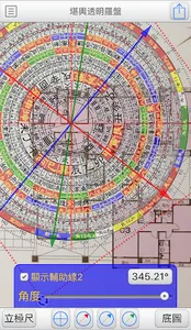
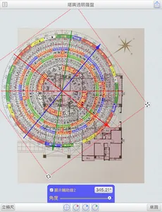
Pole ruler:
●Adjust the degree of "Pole Ruler" and "Cross Line" to match the sitting direction of the house in the base map. (Note: When using the map, the azimuth will be automatically set to the sub-direction of Wushan Mountain, just adjust the direction of the crosshairs.)
●Both provide input of sitting degree and sliding bar to adjust the sitting degree.
●Synchronization:
●The map is the base map: Synchronization will not be checked, because the map is fixed to the Wushanzi direction, just adjust the crosshairs to match the house's direction.
●Photo as the base map: Automatically check the synchronization, when the bottom of the base map is Sitting Mountain, and the top is Xiangshan, just adjust it synchronously. (In case of exception, the synchronization can be unchecked and adjusted separately)
●Transparency: You can adjust the transparency of the vertical ruler according to the depth of the base map color.
●Crosshair: display or not display the crosshair.
●Gesture operation:
●Single-click the pole ruler, you can see the four corner buttons of the pole ruler:
●Press and hold the upper left corner and upper right corner of the pole ruler to zoom and rotate the pole ruler.
●Press and hold the lower left corner and lower right corner of the pole ruler to zoom the pole ruler (if you don’t want to move to the sitting position, please use this button).
●Two fingers to zoom in and out.
●You can share the set of pictures to: cloud printing, WeChat, Line, Messenger, photo album, etc. (depending on the sharing items of the machine).
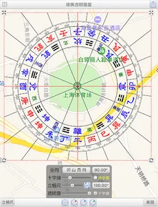
Double Star commentary:
●When the 1st to 9th Yun Xuankong Flying Astrolabe is selected, you can click on the Jiugong position to display the commentary content of the double stars (the commentary content can be edited in the settings).
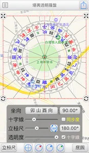
Auxiliary line:
●Provide 3 auxiliary lines in three colors: red, blue and green.
●Click the auxiliary line function below to display the auxiliary line. If you do not want to display it, please cancel the tick.
●Auxiliary line operation:
1. From the pole ruler, press and hold to rotate the degree of the auxiliary line.
2. Enter the degree from the degree button below.
3. Use the slider below to adjust the degree.
Magnetic declination:
●Longitude, latitude and date can be specified, the magnetic declination can be obtained from the NOAA website, and the magnetic declination can also be input manually.
●Magnetic declination can be applied to correct the angle of the base map.
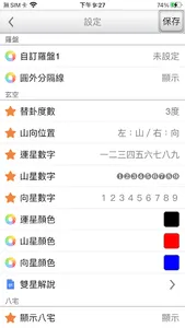
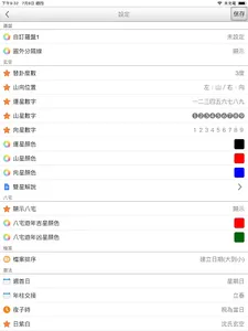
Preferences:
●Customized compass: You can specify the URL for downloading compass image files.
●Dividing line outside the circle: If the dividing line of the pole ruler exceeds the outside of the circle, it can be set whether to display it or not.
●Degree of hexagram replacement: You can set no hexagram replacement, or 3 degrees to allow hexagram replacement.
●Mountain position: set the left and right position of the mountain.
●Lucky star number: The lucky star displays the number symbol.
●Mountain star number: Mountain star displays number symbols.
●Number to the star: Display the number symbol to the star.
●Luck star color: The color of luck star display.
●Mountain star color: The display color of the mountain star.
●Color to the star: display the color to the star.
●Double Star Commentary: You can customize and edit the commentary content of Xuankong Flying Star Double Star.
●Display eight houses: Set whether to display eight houses.
●Auspicious star color in the Year of the Eight-Mansion Tour: the color of the auspicious star.
●The color of the inauspicious stars in the Year of the Eight-Mansion Tour: the color of the inauspicious stars.
●File sorting: You can sort by name or creation date.
●First day of the week: set the day of the week.
●Year Pillar Handover: Set the handover point of Year Pillar solar terms.
●Night time: Provide night time setting.
Sun purple and white: provide five arrangement methods
●Shi Zibai: Provides three arrangement methods
●Language region: The interface language can be switched at any time, providing traditional Chinese and simplified Chinese.
●Interface font: provide font size adjustment.
●Minimum ratio of the base image: 100% is the screen size, 50% is half the screen size (it can be used when the pole ruler needs to be stretched larger than the base image).
●Use web map (google/Baidu): set whether to use web map.
●Screen lock: It can be used for a long time without locking, and the screen will not be turned off.
●Full screen: Turn on or off the full screen.
● This tool is only an auxiliary tool for Fengshui identification, and users need to have relevant knowledge of Fengshui.
● Operation interface: Traditional Chinese, Simplified Chinese.
● At the same time, it supports the display in any direction on the large screen of the tablet.
Basic operation:
1. Add a new file.
2. Press the bottom right button to get the base map.
3. Adjust the degrees of the "Pole Ruler" and "Cross Line" from the bottom to match the orientation of the house on the base map. (Note: When using the map, the azimuth will be automatically set to the sub-direction of Wushan Mountain, just adjust the direction of the crosshairs.)
4. Move the pole ruler to the position you want to measure.
The pole plate provides:
8 grids. Luoshu. Hexagram symbols. 24 mountains
8 grids. 24 hills
24 grids. 24 mountains
●Gossip. 8 grids. No scale
●Gossip. 8 grids
●12 grids. 12 earthly branches
●Mysterious Empty Disk
●Three Yuan Plate. Kaixi Sudu
●Three-Yuan Plate. Time Xian Sudu
●Three-in-one plate. Kaixi Sudu
●Three-in-one disk.
File management: (provide file management, thumbnail preview, easy to manage all the files that have been operated)
●Add new file: Please click "Add" first, and then start the operation of the vertical ruler set.
●Modify file: modify the project name of the file.
●Delete file: After selecting a file, click "Delete" to delete the file.
●File list: Provide information such as thumbnails of the actual set of maps, project names, addresses (can be used to search for maps), seating orientation, and seating degrees.
●Quick Search: Enter text in the upper search bar to find files containing the text in the project name and address.
●Provide Google cloud backup and data recovery function by Google (backup includes package files and settings).
Basemap:
●Map: Capture the map and use it as a base map, which can be displayed in three modes: normal, satellite, and hybrid, and can be searched by entering an address (can be recorded in the current file).
●Album: Select photos from the album and use it as a base map.
●Photography: Through the camera function, take a photo and use it as a base map.
●Edit: Editable cropping and rotating basemap.
Center positioning:
●Purpose: To provide the center position of a certain area of the survey base map.
●Style: Three styles are available: "cross, nine-square grid, and 7x7 grid".
●Fixed display: Check to keep the display all the time, and the status record can be archived.
●The operation method is as follows:
●Place and align the distance shape on a certain area of the base map.
●The distance shape can be stretched, contracted and rotated arbitrarily.
●Press "Place Pole at Center" to place the pole at the center.
●Note: The rotation angle here has nothing to do with the pole ruler, the main purpose of the rotation is to align the base map.
Pole ruler:
●Adjust the degree of "Pole Ruler" and "Cross Line" to match the sitting direction of the house in the base map. (Note: When using the map, the azimuth will be automatically set to the sub-direction of Wushan Mountain, just adjust the direction of the crosshairs.)
●Both provide input of sitting degree and sliding bar to adjust the sitting degree.
●Synchronization:
●The map is the base map: Synchronization will not be checked, because the map is fixed to the Wushanzi direction, just adjust the crosshairs to match the house's direction.
●Photo as the base map: Automatically check the synchronization, when the bottom of the base map is Sitting Mountain, and the top is Xiangshan, just adjust it synchronously. (In case of exception, the synchronization can be unchecked and adjusted separately)
●Transparency: You can adjust the transparency of the vertical ruler according to the depth of the base map color.
●Crosshair: display or not display the crosshair.
●Gesture operation:
●Single-click the pole ruler, you can see the four corner buttons of the pole ruler:
●Press and hold the upper left corner and upper right corner of the pole ruler to zoom and rotate the pole ruler.
●Press and hold the lower left corner and lower right corner of the pole ruler to zoom the pole ruler (if you don’t want to move to the sitting position, please use this button).
●Two fingers to zoom in and out.
●You can share the set of pictures to: cloud printing, WeChat, Line, Messenger, photo album, etc. (depending on the sharing items of the machine).
Double Star commentary:
●When the 1st to 9th Yun Xuankong Flying Astrolabe is selected, you can click on the Jiugong position to display the commentary content of the double stars (the commentary content can be edited in the settings).
Auxiliary line:
●Provide 3 auxiliary lines in three colors: red, blue and green.
●Click the auxiliary line function below to display the auxiliary line. If you do not want to display it, please cancel the tick.
●Auxiliary line operation:
1. From the pole ruler, press and hold to rotate the degree of the auxiliary line.
2. Enter the degree from the degree button below.
3. Use the slider below to adjust the degree.
Magnetic declination:
●Longitude, latitude and date can be specified, the magnetic declination can be obtained from the NOAA website, and the magnetic declination can also be input manually.
●Magnetic declination can be applied to correct the angle of the base map.
Preferences:
●Customized compass: You can specify the URL for downloading compass image files.
●Dividing line outside the circle: If the dividing line of the pole ruler exceeds the outside of the circle, it can be set whether to display it or not.
●Degree of hexagram replacement: You can set no hexagram replacement, or 3 degrees to allow hexagram replacement.
●Mountain position: set the left and right position of the mountain.
●Lucky star number: The lucky star displays the number symbol.
●Mountain star number: Mountain star displays number symbols.
●Number to the star: Display the number symbol to the star.
●Luck star color: The color of luck star display.
●Mountain star color: The display color of the mountain star.
●Color to the star: display the color to the star.
●Double Star Commentary: You can customize and edit the commentary content of Xuankong Flying Star Double Star.
●Display eight houses: Set whether to display eight houses.
●Auspicious star color in the Year of the Eight-Mansion Tour: the color of the auspicious star.
●The color of the inauspicious stars in the Year of the Eight-Mansion Tour: the color of the inauspicious stars.
●File sorting: You can sort by name or creation date.
●First day of the week: set the day of the week.
●Year Pillar Handover: Set the handover point of Year Pillar solar terms.
●Night time: Provide night time setting.
Sun purple and white: provide five arrangement methods
●Shi Zibai: Provides three arrangement methods
●Language region: The interface language can be switched at any time, providing traditional Chinese and simplified Chinese.
●Interface font: provide font size adjustment.
●Minimum ratio of the base image: 100% is the screen size, 50% is half the screen size (it can be used when the pole ruler needs to be stretched larger than the base image).
●Use web map (google/Baidu): set whether to use web map.
●Screen lock: It can be used for a long time without locking, and the screen will not be turned off.
●Full screen: Turn on or off the full screen.
● This tool is only an auxiliary tool for Fengshui identification, and users need to have relevant knowledge of Fengshui.
● Operation interface: Traditional Chinese, Simplified Chinese.
● At the same time, it supports the display in any direction on the large screen of the tablet.
Show More