Geo field will help you render your Lat Long points in a map, so you can easily allocate them in the field. in the other hand, Geo field will generate an excel file with all the photos that you take in the field, with its lat, long location, and description data
The main idea of the app, is to import an excel file with specific format that holds a list of Coordinates points. the app will render them in a map, so you can easly find your points in the field
Step 1: Create an excel file named 'eme.xls', with 5 columns as follows
Point no | Latitude | Longitude | Elevation | Description
Step 2: Save the file in your SD card in your mobile
Step 3: In the App, Press the Import icon to select the excel files that you have created 'eme.xls'
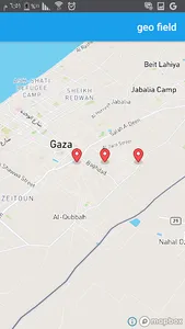
Step 4: After importing the file, you can go to the Map icon, you will see all your points that you have added in the excel file, have been loaded into the map
Step 5: the app allows the user to take photos in the field, the app will save the photos in a specific folder in the mobile called "geo_images". and its corresponding information in a separated excel file that you can send it anywhere via email
The main idea of the app, is to import an excel file with specific format that holds a list of Coordinates points. the app will render them in a map, so you can easly find your points in the field
Step 1: Create an excel file named 'eme.xls', with 5 columns as follows
Point no | Latitude | Longitude | Elevation | Description
Step 2: Save the file in your SD card in your mobile
Step 3: In the App, Press the Import icon to select the excel files that you have created 'eme.xls'
Step 4: After importing the file, you can go to the Map icon, you will see all your points that you have added in the excel file, have been loaded into the map
Step 5: the app allows the user to take photos in the field, the app will save the photos in a specific folder in the mobile called "geo_images". and its corresponding information in a separated excel file that you can send it anywhere via email
Show More