65 - OSSAU VALLEY - IGN 1 / 25,000
Atlantic Pyrenees
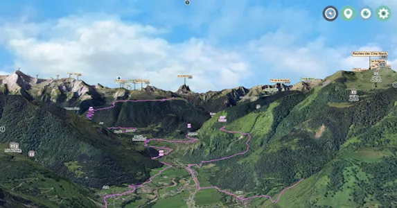
Arrudy - Laruns - Eaux-Bonnes - Gourette - Portalet
○ Top3D card 1.25,000
Area: 600 km2
North: Pic d'Escurets / Col de Marie Blanque / Arudy / Col des Voix
In the South: Pico Sancha Collons (Spain) / Pourtalet / Formigal / Astún / Somport
○ Reference IGN card (s):
IGN N ° 1547OT - OSSAU / ASPE VALLEY / PYRENEES PN
IGN N ° 1647OT - VIGNEMALE
IGN N ° 1546ET - LARUNS / GOURETTE / COL D'AUBISQUE / OSSAU VALLEY
IGN N ° 1546OT - OLORON - SAINTE-MARIE / VALEE D'ASPE
○ Top3D is designed for the terrain, for the beginner as for the mountain dweller.
○ Top3D is very simple to use, you download your map and off you go!
○ The app has an interactive IGN 1.25 000 3D map, immersive.
○ Usable OFFLINE, mountain requires!
○ The functions are directly accessible from 3D.
○ Progressive display of pictograms.
○ The pictograms of peaks, passes, lakes, towns, refuges ... allow a unique location in the relief of the map or the aerial image.
○ In Orientation table mode, you can find your way and the direction to take, in complete safety.
Take full advantage of the benefits of this 1.25000 3D MAP and its AERIAL IMAGE.
Good hike to all.
3D IMMERSIVE FUNCTIONS
○ Intuitive and precise controls ... at your fingertips.
○ Aerial view, overview
○ View and move on the ground
○ COMPASS
○ GPS
○ Compass + GPS + Ground view = Portable orientation table!
○ Functions and menu in direct display in 3D
○ Import of .GPX .KML trace from IGNGéoportail
○ Zoom
○ Search engine with flyover to the desired location.
GPS
The GPS of your phone is used for geolocation, it is particularly useful to see its position in the relief in case of poor visibility on the ground, fog, snow.
COMPASS
The compass mode is integrated in 3D, the cardinal points are oriented according to manual movements or the map is automatically oriented to the North by activating the compass mode directly from 3D.
RELIEF & 3D GROUND VIEW
The aerial view and the ground view illustrate the general relief at an optimized level of precision, it is displayed on the screen according to the 1.25 000 map or the aerial image.
The movement of the camera on the ground allows you to appreciate the details of the route to follow in total immersion in the relief.
Interactive 3D Application - Facing South ® TOP3D ® www.faceausud.com
Trademark and Registered Models 486299 08082013 - 12 3 953 606 © All rights reserved - Reproduction prohibited
With the kind participation of Helge Foerster jPCT3Dengine Copyright © 2010
Atlantic Pyrenees
Arrudy - Laruns - Eaux-Bonnes - Gourette - Portalet
○ Top3D card 1.25,000
Area: 600 km2
North: Pic d'Escurets / Col de Marie Blanque / Arudy / Col des Voix
In the South: Pico Sancha Collons (Spain) / Pourtalet / Formigal / Astún / Somport
○ Reference IGN card (s):
IGN N ° 1547OT - OSSAU / ASPE VALLEY / PYRENEES PN
IGN N ° 1647OT - VIGNEMALE
IGN N ° 1546ET - LARUNS / GOURETTE / COL D'AUBISQUE / OSSAU VALLEY
IGN N ° 1546OT - OLORON - SAINTE-MARIE / VALEE D'ASPE
○ Top3D is designed for the terrain, for the beginner as for the mountain dweller.
○ Top3D is very simple to use, you download your map and off you go!
○ The app has an interactive IGN 1.25 000 3D map, immersive.
○ Usable OFFLINE, mountain requires!
○ The functions are directly accessible from 3D.
○ Progressive display of pictograms.
○ The pictograms of peaks, passes, lakes, towns, refuges ... allow a unique location in the relief of the map or the aerial image.
○ In Orientation table mode, you can find your way and the direction to take, in complete safety.
Take full advantage of the benefits of this 1.25000 3D MAP and its AERIAL IMAGE.
Good hike to all.
3D IMMERSIVE FUNCTIONS
○ Intuitive and precise controls ... at your fingertips.
○ Aerial view, overview
○ View and move on the ground
○ COMPASS
○ GPS
○ Compass + GPS + Ground view = Portable orientation table!
○ Functions and menu in direct display in 3D
○ Import of .GPX .KML trace from IGNGéoportail
○ Zoom
○ Search engine with flyover to the desired location.
GPS
The GPS of your phone is used for geolocation, it is particularly useful to see its position in the relief in case of poor visibility on the ground, fog, snow.
COMPASS
The compass mode is integrated in 3D, the cardinal points are oriented according to manual movements or the map is automatically oriented to the North by activating the compass mode directly from 3D.
RELIEF & 3D GROUND VIEW
The aerial view and the ground view illustrate the general relief at an optimized level of precision, it is displayed on the screen according to the 1.25 000 map or the aerial image.
The movement of the camera on the ground allows you to appreciate the details of the route to follow in total immersion in the relief.
Interactive 3D Application - Facing South ® TOP3D ® www.faceausud.com
Trademark and Registered Models 486299 08082013 - 12 3 953 606 © All rights reserved - Reproduction prohibited
With the kind participation of Helge Foerster jPCT3Dengine Copyright © 2010
Show More