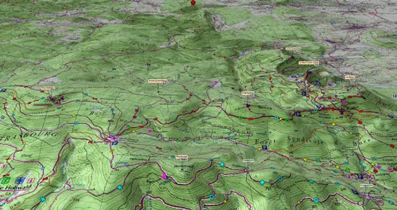
600 km2 area of the 1/25000 map:
North West: Saulxures sur-Moselette
North East: Markstein, Lintal, Sengern
South East: Board of the Beautiful Girls, Michelbach
Top3D Ballons des Vosges map contains:
1 IGN 1.25 000 map
1 AERIAL IMAGE
Informative pictograms
Signage of the Club Vosgien
Top3D Club Vosgien topoguide:
20 Hikes, descriptions and dynamic route by stages.
Preview and test your topoguide,
ONLINE, ON YOUR COMPUTER:
https://www.faceausud.com/Top3D-BallonsDesVosges_WebGL/
1 - Le Ménil - Tour of the Granges valley
2 - Le Ménil - The Three Heads
3 - Fresse sur Moselle - Le Ruisseau de la Colline: by mountains and valleys
4 - Bussang - Drumont circuit from Bussang
5 - Le Thillot - Le Ballon de Servance
6 - St Maurice-sur-Moselle - Balloons of Servance and Alsace
7 - Sewen - Old farm hike
8 - Sewen and its lakes
9 - Circuit of Lac des Perches and Etangs de Neuweiher
10 - Riervescemont - Le Baerenkopf
11 - Sentheim - Burchberg loop
12 - Thann - The Pastetenplatz and the Wotan oak
13 - Wegscheid - Circuit des Rochers
14 - Moosch - Volcanic domain of Vogelsteine
15 - Moosch - From the banks of the Thur to the balconies of Geishouse
16 - Geihouse - Sports and panoramic circuit of the Grand Ballon
17 - Storckensohn - The Green Grass
18 - Husseren-Wesserling - Panoramic circuit of Chauvelin
19 - From Wesserling to Markstein and Treh
20 - From Lauch to the Chaumes of Steinlebach and Auberlauchen
○ Top3D is designed for the terrain, for the beginner as for the mountaineer.
○ Top3D is very easy to use, you download your map and go!
○ The 3D map embeds the 3D IGN 1.25 000 map and aerial, interactive and immersive imagery.
○ Usable OFFLINE
○ The functions are directly accessible from 3D.
○ Progressive display of pictograms.
○ The pictograms of summits, passes, lakes, towns, refuges ... allow an unprecedented location in the relief of the map or the aerial image.
○ In Orientation Table mode, find your way and the direction to take, in total safety.
Take full advantage of this 3D 1.25000 MAP and its AERIAL IMAGE.
Good hike to all.
3D IMMERSIVE FUNCTIONS
○ Intuitive and precise controls ... at your fingertips.
Easy ergonomics: 2 fingers or double click
○ Air and ground movement
○ COMPASS
○ GPS
○ COMPASS + GPS + GROUND VIEW = Portable orientation table!
○ Functions and menu in direct display in 3D
○ IMPORT of .GPX .KML trace (make your .kml on IGN Géoportail)
○ Immersive ZOOM
○ SEARCH ENGINE with flyover to the desired location.
GPS
The GPS locates you everywhere and the camera is placed on your position on the ground,
very useful for 360 ° orientation on the ground, in bad weather, fog or snow.
COMPASS
The compass mode is integrated into 3D, the cardinal points orient themselves according to manual movements or the map automatically orientates to North by activating the compass mode.
RELIEF & 3D GROUND VIEW
The aerial view and the ground view illustrate the general relief at an optimized level of precision, it is displayed on the screen according to the 1.25000 map or the aerial image.
Moving the camera on the ground allows you to appreciate the details of the route to be followed in total immersion in the relief.
IGN® / Club Vosgien® card
www.ignrando.fr / www.club-vosgien.eu
Interactive 3D application - Facing the South ® TOP3D ® www.faceausud.com
Trademarks and registered models 486299 08082013 - 12 3 953 606 © All rights reserved - Reproduction prohibited
Courtesy of Helge Foerster jPCT3Dengine Copyright © 2010
Show More