Presentation of GeoConvois
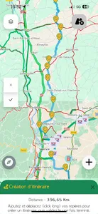
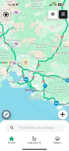
GéoConvois (v2) is a mobile application that offers a cartographic environment dedicated to exceptional transport. It offers many features to help drivers, pilot vehicles and motorcycle guides optimize their journeys, while minimizing risks and disruptions to other traffic.
GeoConvois Key Features
Among the functionalities offered by GéoConvois (v2), we find:
Planning and saving personalized routes
Display of services and traffic information in real time
A community space to share advice, experiences and best practices
Additional features to improve driver safety and conduct
Integration of base maps such as Google Maps, Waze, Geoportal and Street View
Information on bridge heights, speed limits and control zones
Real-time weather alerts (snow, fog, rain, ice)
Benefits of GeoConvois
By using GéoConvois (v2), players in the exceptional transport sector benefit from numerous advantages, such as:
Better management of journeys and routes
Reduced traffic and infrastructure risks
Improved safety and working comfort for drivers
Optimization of costs related to exceptional transport
A contribution to the preservation of the environment by limiting CO2 emissions
Show More