This application can communicate with a layout navigator LN-100 and Robotic TS or
TS with Bluetooth connection.
By using this, you can perform Stakeout of 2D/3D design data and Topo measurement of 2D/3D dimensional point data.
Sales Points :
1. Easy and Intuitive Operation
Anybody can start using in short learning time with simple icons and graphical
display screen and shallow hierarchical menu structure.
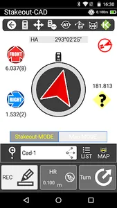
Especially, Topo and Stakeout Point routine, which is the basic function, are with simple operation and intuitive displays.
2. Use CAD drawing data
The stakeout point can be selected directly on the CAD drawing screen.
Also, the KS-Navi software is having CAD View function, CAD drawing can be viewed without bringing the drawing on the paper to the site.
3. Use Road Alignment data
Road Alignment can be created by entering simple parameters of layer method on the KS-Navi.
4. Unique function based on the investigation
The KS-Navi software has useful but limited functions of Topo and Stakeout, which was determined from market research and includes 4 important and necessary functions.
(Stakeout Line/Stakeout CAD/Cross Section Topo (Alignment)/Stakeout Alignment)
5. Compatible with iSurvey3D (KENSETSU SYSTEM Co.,Ltd Desktop Alignment Calculation
Software)
With KS-Navi, you can automatically display Cross Section Topo data. It can
output to SIMA format. iSurvey3D can automatically import Cross Section Topo
data (Import SIMA format file), so you do not have to draw it again.
※ iSurvey3D Download Link : www.kentem.co.id
TS with Bluetooth connection.
By using this, you can perform Stakeout of 2D/3D design data and Topo measurement of 2D/3D dimensional point data.
Sales Points :
1. Easy and Intuitive Operation
Anybody can start using in short learning time with simple icons and graphical
display screen and shallow hierarchical menu structure.
Especially, Topo and Stakeout Point routine, which is the basic function, are with simple operation and intuitive displays.
2. Use CAD drawing data
The stakeout point can be selected directly on the CAD drawing screen.
Also, the KS-Navi software is having CAD View function, CAD drawing can be viewed without bringing the drawing on the paper to the site.
3. Use Road Alignment data
Road Alignment can be created by entering simple parameters of layer method on the KS-Navi.
4. Unique function based on the investigation
The KS-Navi software has useful but limited functions of Topo and Stakeout, which was determined from market research and includes 4 important and necessary functions.
(Stakeout Line/Stakeout CAD/Cross Section Topo (Alignment)/Stakeout Alignment)
5. Compatible with iSurvey3D (KENSETSU SYSTEM Co.,Ltd Desktop Alignment Calculation
Software)
With KS-Navi, you can automatically display Cross Section Topo data. It can
output to SIMA format. iSurvey3D can automatically import Cross Section Topo
data (Import SIMA format file), so you do not have to draw it again.
※ iSurvey3D Download Link : www.kentem.co.id
Show More