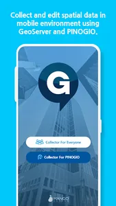
Implementing collect and edit functions in a mobile environment for spatial data(Point, Polyline, Polygon) using public OGC international standard WFS-T service such as GeoServer or PINOGIO platform from MangoSystem Inc.
[ Main Functions]
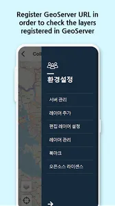
● Manage Server
- Register/Modify/Delete information of public data collecting PINOGIO or other GIS server
- Option to register multiple servers and collect data
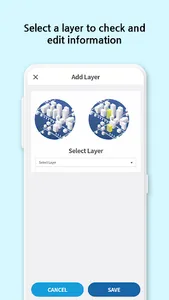
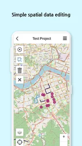
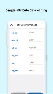
● Edit spatial and attribute data
- Support edit functions(add/modify/delete) for data selected by the user
- Support geometries types like Point, LineString, Polygon
- Support attributes editing
- Attach photo (when using PINOGIO platform)
● Layer Manage
- Support layer ordering
- Support layer removal function
● Bookmark Managing
- Save/Delete region interested by the user
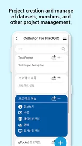
● Project Managing
- Create/Edit project
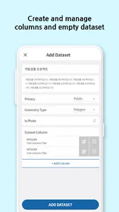
● Project’s Dataset Managing
- Create/Edit/Delete empty dataset
- Create/Edit/Delete field
● Project members Managing
- Inviting members to project and request to add as a member
- Setting permissions for members
- Kicking out members from project and leaving projects
[ Note]
● Support all main international coordinate systems.
● We recommend Geoserver’s version 2.5 or higher
● GPS function allows you moving to your current position
[ Used OpenSource Project ]
● Ionic
● Ionic-native
● Cordova
● Cordova-Android
● Cordova-iOS
● Angular
● Leaflet
● Jquery
● ngx-translate
● proj4
Spatial data is in my hands! gPocket - the best data collection tool!
[ Main Functions]
● Manage Server
- Register/Modify/Delete information of public data collecting PINOGIO or other GIS server
- Option to register multiple servers and collect data
● Edit spatial and attribute data
- Support edit functions(add/modify/delete) for data selected by the user
- Support geometries types like Point, LineString, Polygon
- Support attributes editing
- Attach photo (when using PINOGIO platform)
● Layer Manage
- Support layer ordering
- Support layer removal function
● Bookmark Managing
- Save/Delete region interested by the user
● Project Managing
- Create/Edit project
● Project’s Dataset Managing
- Create/Edit/Delete empty dataset
- Create/Edit/Delete field
● Project members Managing
- Inviting members to project and request to add as a member
- Setting permissions for members
- Kicking out members from project and leaving projects
[ Note]
● Support all main international coordinate systems.
● We recommend Geoserver’s version 2.5 or higher
● GPS function allows you moving to your current position
[ Used OpenSource Project ]
● Ionic
● Ionic-native
● Cordova
● Cordova-Android
● Cordova-iOS
● Angular
● Leaflet
● Jquery
● ngx-translate
● proj4
Spatial data is in my hands! gPocket - the best data collection tool!
Show More