Hunter Maps - allowing the program to determine its location and direction of movement relative to the hunting grounds. The maps are always up to date information about the boundaries and areas of land (public, fixed, natural resources protection zones).
The program allows you to:
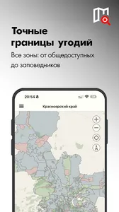
- To determine your location relative to the hunting grounds (public, fixed, zones of protection of natural resources), using GLONASS-GPS
- To carry out exploration, with a mark on the map of places looking for further production of hunting
- Exchange of hunting places with your friends
- Build a route of movement to the place of hunting in the Navigator
- To obtain accurate weather information in the field of hunting, such as sunrise and sunset, wind speed and direction, atmosvernoe davoenie and air temperature
The program allows you to:
- To determine your location relative to the hunting grounds (public, fixed, zones of protection of natural resources), using GLONASS-GPS
- To carry out exploration, with a mark on the map of places looking for further production of hunting
- Exchange of hunting places with your friends
- Build a route of movement to the place of hunting in the Navigator
- To obtain accurate weather information in the field of hunting, such as sunrise and sunset, wind speed and direction, atmosvernoe davoenie and air temperature
Show More