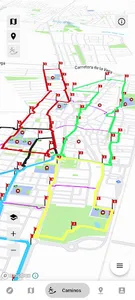
The Azuqueca de Henares App includes "Safe School Paths", five circular routes that pass through the schools and institutes of the municipality, to make the mobility of the girls and boys of Azuqueca safer.
- You will be able to see the "MetroMinuto" of Azuqueca de Henares, a synoptic map that measures the distances between its points of interest and the average time it takes to travel between them. You can also check the distance between your current location with the most relevant places.
- In the News section you can stay informed of the most relevant news from your town hall.
- You will also have a direct communication tool with the town hall to present your suggestions or warn of a mobility problem in your neighbourhood.
- And there are even more features...
Show More