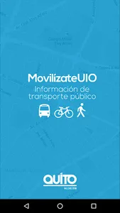
As in the most important cities in the world, the Municipality of the Metropolitan District of Quito with the support of Google Maps Inc., makes available to local and international citizens information regarding bus routes, so that they can travel SAFELY and notify EMERGENCIES, INCIDENTS, COMPLAINTS in the city's Public Transport, routes that are generated by the Ministry of Mobility (GTFS), as well as reports of both SERVICE and SECURITY in the DMQ.
Likewise, taking into account that more than 70% of citizens mobilize by public transport and that a means is required by which citizens can directly report incidents in both the service and security, for this reason the application is created "MovilízateUIO", which is constantly updated and currently offers the following functionalities:
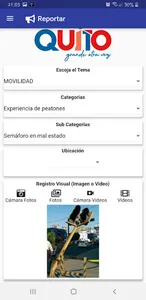
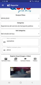
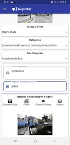
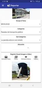
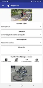
INCIDENT REPORT BOTH OF SERVICE AND SECURITY, EMERGENCY
* The function of reporting incidents on the SERVICE and infrastructure of public transport, SECURITY, bicycle lanes and pedestrian networks, state of the roads, sidewalks, was designed under the concept of "crowdsourcing"; which takes advantage of the collective knowledge of citizens, to systematize and channel experiences through a digital tool. In this way, it will allow the authorities to have information generated in the territory and to focus their resources / projects correctly.
There are multiple categories and subcategories that currently will incrementally include all municipal service, safety, and road entities, integrating into systems such as BAJATE AL ACOSO sending an SMS directly to the number 6367 from the same application in which a video or photography.
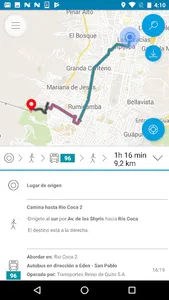
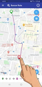
ROUTES AND FREQUENCIES OF THE INTEGRATED AND CONVENTIONAL TRANSPORT SYSTEM
* Find the fastest route to move by public transport from one point to another within the Metropolitan District of Quito with TAP technology on the map - DMQ
* Know the approximate time it would take to get from one point to another in the DMQ, mobilizing by public transport and will be immediately integrated with the Exploitation Assistance System that will be implemented in the city in the coming years in this way to have real time of arrival of a unit.
* Reading QR codes that will be available in the transport units
* Save the routes consulted, even when there is no Internet connection.
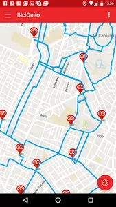
CYCLOVES AND BICYCLE STATIONS
* View the DMQ bicycle lane network
* Check the locations of all the DMQ BiciQuito stations.
Security, Reports, Incidents, timely attention ......... MovilizateUIO
Likewise, taking into account that more than 70% of citizens mobilize by public transport and that a means is required by which citizens can directly report incidents in both the service and security, for this reason the application is created "MovilízateUIO", which is constantly updated and currently offers the following functionalities:
INCIDENT REPORT BOTH OF SERVICE AND SECURITY, EMERGENCY
* The function of reporting incidents on the SERVICE and infrastructure of public transport, SECURITY, bicycle lanes and pedestrian networks, state of the roads, sidewalks, was designed under the concept of "crowdsourcing"; which takes advantage of the collective knowledge of citizens, to systematize and channel experiences through a digital tool. In this way, it will allow the authorities to have information generated in the territory and to focus their resources / projects correctly.
There are multiple categories and subcategories that currently will incrementally include all municipal service, safety, and road entities, integrating into systems such as BAJATE AL ACOSO sending an SMS directly to the number 6367 from the same application in which a video or photography.
ROUTES AND FREQUENCIES OF THE INTEGRATED AND CONVENTIONAL TRANSPORT SYSTEM
* Find the fastest route to move by public transport from one point to another within the Metropolitan District of Quito with TAP technology on the map - DMQ
* Know the approximate time it would take to get from one point to another in the DMQ, mobilizing by public transport and will be immediately integrated with the Exploitation Assistance System that will be implemented in the city in the coming years in this way to have real time of arrival of a unit.
* Reading QR codes that will be available in the transport units
* Save the routes consulted, even when there is no Internet connection.
CYCLOVES AND BICYCLE STATIONS
* View the DMQ bicycle lane network
* Check the locations of all the DMQ BiciQuito stations.
Security, Reports, Incidents, timely attention ......... MovilizateUIO
Show More