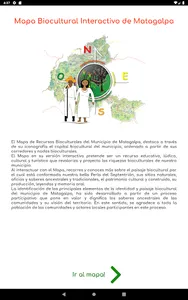
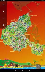
The Map of Biocultural Resources of the Municipality of Matagalpa, highlights through its iconography the biocultural capital of the municipality, ordered from its biocultural corridors and nodes.
The Map in its interactive version aims to be an educational, recreational, cultural and tourist resource that revalues and projects the biocultural riches of our municipality.
By interacting with the Map, you visit and learn more about the biocultural landscape that makes up our beautiful Pearl of the North, its natural sites, ancient and traditional crafts and knowledge, the cultural and built heritage, its production, legends and oral memory.
The identification of the main elements of the identity and biocultural landscape of the municipality of Matagalpa, has been developed from a participatory process that values and dignifies the ancestral knowledge of the communities and their vision of the territory. In this sense, we thank the entire population of the communities and local actors participating in this process.
Credits:
Matagalpa Municipal Mayor's Office
ODESAR, Organization for Economic and Social Development for the Urban and Rural Area
Prepared with the Support of:
Government of Navarra
Felipe Rinaldi Foundation
With advice from:
Raís Institute, El Salvador
Under the project:
"Matagalpa, Green Municipality promoting the sustainable development of its surroundings."
Graphic design:
ODESAR, Organization for Economic and Social Development for the Urban and Rural Area
Show More