PhotoStopper, the app for geolocated routes to (re)discover local heritage in Hauts-de-France.
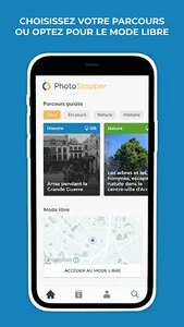
Connect, the app geolocates you and offers you a range of routes available around you to do on foot or by bike, alone or with your family. These routes with history and nature themes present to you in a playful way the richness of the history of your city and the ecosystems of the natural spaces around you.
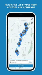
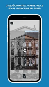
At each step, exclusive content related to the place where you are. This content can be composed of an archival photograph or a representation of the place supplemented by a description, revealing the history of the buildings or the people in the image, presenting a rare animal living in the environment where where you are, or relating a local legend... The photographs are sometimes equipped with an interactive slider allowing you to perform a before/after scan revealing the evolution of a building, a landscape, or even the seasonal evolution of an atypical tree.
Each course is co-created with one or more local experts.
Connect, the app geolocates you and offers you a range of routes available around you to do on foot or by bike, alone or with your family. These routes with history and nature themes present to you in a playful way the richness of the history of your city and the ecosystems of the natural spaces around you.
At each step, exclusive content related to the place where you are. This content can be composed of an archival photograph or a representation of the place supplemented by a description, revealing the history of the buildings or the people in the image, presenting a rare animal living in the environment where where you are, or relating a local legend... The photographs are sometimes equipped with an interactive slider allowing you to perform a before/after scan revealing the evolution of a building, a landscape, or even the seasonal evolution of an atypical tree.
Each course is co-created with one or more local experts.
Show More