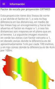
The application allows to calculate the combined scale factor that results when passing surveys to the official CRTM05 projection. The location for the scale factor is taken into account by the projection and the height above sea level for the factor by height to obtain the combined factor.
Avoid the most common mistakes you make on surveying, construction and design projects:
- use ground distances in plans or CRTM05 designs
- use CRTM05 distances to design and build precast structures
- errors in closing traverse
- confuse local coordinates with national coordinates
- use CRTM05 distances in the field
With this application you can easily obtain the combined scale factor for your current location or any part of the country just by typing in the coordinates and height above sea level.
Multiply the field distance by the combined scale factor to get the distance in CRTM05. For example, in a site where the scale factor is 0.9998, a distance of 1000 meters in the field becomes 999.80 meters in CRTM05.
Examples:
Place F.E.C. Difference in 1000m
Parrot 1.00038 38cm
Puntarenas 1.00000 <1cm
Tarbaca 0.9996 40cm
Show More