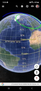
This APP predicts the position of a Satellite with the TLE2 data through the SGP4 SDP4 protocol. It gives us the position in Longitude, Latitude and Altitude as well as the Grid, Maidenhead Locator System (QTH Locator and IARU Locator), also the Orbital parameters and data of the next step by the local position where we are (QTH), we can see a graph in polar coordinates of the next step, in location data Azimuth, Elevation, Time etc. It allows us to see the orbit on a map and generates a KML file in an external folder /Documents/Kml that allows us to project the satellite's orbit in Google Earth.
Show More