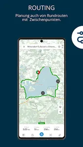
The Bayernnetz für Radler App 2020 contains many functions of the PC version (www.radlland-bayern.de). For use on the go, it offers u. a.
- a cycle route planner with various routing options
- Information on the calculated route such as length, driving time, elevation profile
and incline meter,
- extensive information for the approx. 125 routes of the Bavarian network for cyclists,
- Display of more than 60,000 km of cycle networks in Bavaria and the neighboring regions
with information about the path surface,
- Use of different background maps and aerial photos,
- the display of the current position.
Routes worked out on the PC can be conveniently transferred to the app using a QR code. You need a data connection to use the app.
Show More