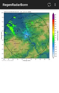
Rain radar Bonn shows current precipitation in the greater Bonn or Jülich area (max. Radius 100 KM). The display takes the form of animated radar images, which visualize the development of the precipitation over the period of the last 60 minutes. Different display forms (moments) of the precipitation estimate can be selected.
The radar images shown come from the website of the Meteorological Institute of the University of Bonn and the Jülich Research Center (http://www.meteo.uni-bonn.de/messdaten/radarbilder). Since this is a voluntary service, we unfortunately cannot guarantee permanent availability of the service.
The time information on the radar image is UTC, so two hours must be added for Bonn and Jülich. Further information on the radar and the interpretation of the radar images: http://www.meteo.uni-bonn.de/messdaten/radarbilder/informationen-zum-radar
The source code of the app is available here: https://bitbucket.org/boden/regenradarbonn
Show More