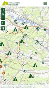
The Trekkingerlebnis Steigerwald App takes you on a detailed map through the entire forest area of the Steigerwald. Either along selected tours or free on the route system consisting of forest roads and dirt roads, you can explore the Steigerwald. Along the paths, in addition to the tour suggestions and trekking sites, there are also forest attractions, restaurants and food markets.
The app is linked to an online booking system that allows you to book all trekking sites. After completing the booking and payment, you will immediately receive a confirmation email.
The card works even if you have no reception. When you use the GPS function of your phone, you always know exactly where you are and what sights you are passing during your hike.
In addition to the app, the website trekkingerlebnis.de provides further information. Here, for example, the trekking areas are described, because each place has a special character. Learn more about the origins of the squares as well as the special cultural and historical significance of the forest villages. Playful tasks that can be done in the squares are also described.
In addition, the website provides important information on trekking in the Steigerwald, forest fire hazards, severe weather warnings and other safety information.
The map covers the area of Steigerwald in the districts of Schweinfurt, Hassberge and Bamberg.
The main features of the Trekking Experience Steigerwald app:
- approx. 150 km of hiking trails divided into a "Great Northern Tour" and a "Great Southern Tour"
- detailed map material in different zoom levels (works offline)
- own localization on the map
- topographical map showing different types of land use with elevation profile
- User rules
Features on the mobile site:
- Tips for trekking in the Steigerwald
- behavior in the forest
- Rescue Points
- Forest fire danger
- Equipment
- Questions and answers!
- packing list
- Information about places and bookings
- Tour suggestions
Show More


