Basing on tests with street children, VolksNav was developed for children, the blind, those who can't read maps etc.
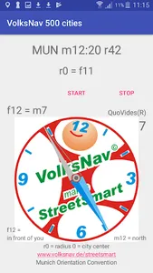
It divides 500 world cities like a cake into 12 sectors, forming location codes which are a better answer to the question "where?" than names, post codes, lat/lon or "here".
The app uses GPS and compass and - a worldwide innovation - indicates the direction to the centre of town, and this only with text !!
Such tools allow a self guiding as elegant as in Rio de Janeiro around the Christ statue:
- inwards/outwards
and
- clockwise / counter clockwise.
The main benefits are
- more awareness for locations, directions, distances and angles
- a language for international understanding (Orientation Esperanto)
Show More