Loco2 WEB VERSION here: http://dmini.eu/map/
full functional but with no background location.
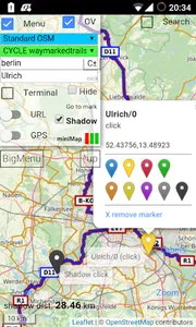
- OpenStreetMap - many switchable tiles (standard / topographic / etc) - Cycle / Hiking (Waymarked Trails) overlays.
- nick/channel style design (additional editable markers, descriptions, tracks, friends) - view of other users location - share location (if requested, also as background location) - calculate distances between points.
full functional but with no background location.
- OpenStreetMap - many switchable tiles (standard / topographic / etc) - Cycle / Hiking (Waymarked Trails) overlays.
- nick/channel style design (additional editable markers, descriptions, tracks, friends) - view of other users location - share location (if requested, also as background location) - calculate distances between points.
Show More