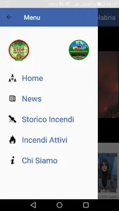
The Stop Calabria Fires Committee (or CSI Calabria) consists of free citizens and non-party associations gathered spontaneously to form a common front against the fire phenomenon.
The aim of the CIS Calabria is the preservation of forests and of the Calabrian landscape heritage.
The Stop Fires Calabria Committee aims to:
1. To investigate, expose and inform civil society about the causes that led to the summer 2017 DISASTER.
2. To promote a plural and multidisciplinary debate for the elaboration of proposals which go to mitigate the scourge of fires.
3. Make a network of associations at municipal level that deals with the protection of forests and of the Calabrian landscape heritage.
The CSI Calabria was formed on August 25, 2017 in Camigliatello Silano (CS) setting as the basis of its action the previous two experiences: the initiative to raise awareness and denounces held in the municipality of Longobucco association 'We turn off the fire, light the future' and by this online petition on "change.org" platform (https://www.change.org/p/al-presidente-della-regione-calabr...) entitled "Fire CALABRIA 2017: stop the Environmental dISASTER! #stopincendicalabria ".
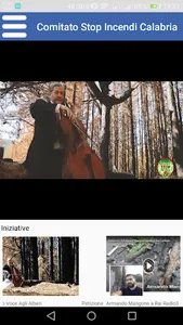
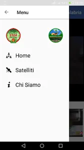
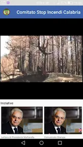
L 'app contains a number of links to posts facebook published reletive the initiatives undertaken by the Committee Stop Fires Calabria and by' Association We turn off the fire, turn on the future of Longobucco (CS). The opening video was made in Longobucco forests hit hard by the criminal fire.
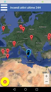
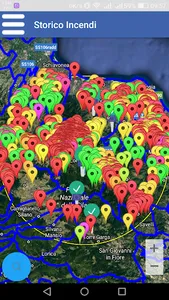
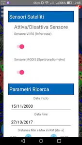
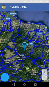
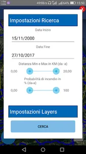
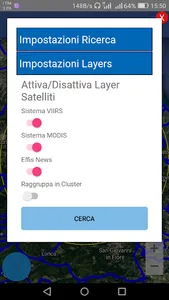
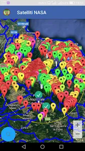
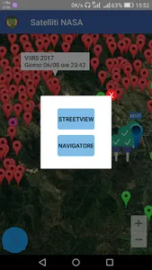
A section is dedicated to the geo-referencing of data on thermal anomalies detected by MODIS systems and VIIRS NASA. Using filters you can search in a timely geo-referenced map from 2000 to October of 2017 in the whole of Calabria up to a proximity radius 20 km from the selected point on the map.
They are indicative, incomplete and unofficial. The study wants to just give you an idea of what happened in the season 2017. On the map you can also select the geo-referencing of EFFIS news, a selection of news from the press on forest fires in Europe (Nell 'app there are just those referring to Calabria up to October 2017), updated daily by EFFIS team of the European commission. News can be browsed by clicking on the pinup, where present, the European Union flag. It will also be possible to view the data of the thermal anomalies detected in the last 24 hours by nasa satellites, data that is updated every now and set an audible alarm to app active. L 'app is experimental and only wants to give the idea of what is happening and has happened in Calabria.Non replaces the official data collected on the ground by the relevant institutions.
The aim of the CIS Calabria is the preservation of forests and of the Calabrian landscape heritage.
The Stop Fires Calabria Committee aims to:
1. To investigate, expose and inform civil society about the causes that led to the summer 2017 DISASTER.
2. To promote a plural and multidisciplinary debate for the elaboration of proposals which go to mitigate the scourge of fires.
3. Make a network of associations at municipal level that deals with the protection of forests and of the Calabrian landscape heritage.
The CSI Calabria was formed on August 25, 2017 in Camigliatello Silano (CS) setting as the basis of its action the previous two experiences: the initiative to raise awareness and denounces held in the municipality of Longobucco association 'We turn off the fire, light the future' and by this online petition on "change.org" platform (https://www.change.org/p/al-presidente-della-regione-calabr...) entitled "Fire CALABRIA 2017: stop the Environmental dISASTER! #stopincendicalabria ".
L 'app contains a number of links to posts facebook published reletive the initiatives undertaken by the Committee Stop Fires Calabria and by' Association We turn off the fire, turn on the future of Longobucco (CS). The opening video was made in Longobucco forests hit hard by the criminal fire.
A section is dedicated to the geo-referencing of data on thermal anomalies detected by MODIS systems and VIIRS NASA. Using filters you can search in a timely geo-referenced map from 2000 to October of 2017 in the whole of Calabria up to a proximity radius 20 km from the selected point on the map.
They are indicative, incomplete and unofficial. The study wants to just give you an idea of what happened in the season 2017. On the map you can also select the geo-referencing of EFFIS news, a selection of news from the press on forest fires in Europe (Nell 'app there are just those referring to Calabria up to October 2017), updated daily by EFFIS team of the European commission. News can be browsed by clicking on the pinup, where present, the European Union flag. It will also be possible to view the data of the thermal anomalies detected in the last 24 hours by nasa satellites, data that is updated every now and set an audible alarm to app active. L 'app is experimental and only wants to give the idea of what is happening and has happened in Calabria.Non replaces the official data collected on the ground by the relevant institutions.
Show More