This is the first GIS based app developed for MC Shimla by the Himalayan Association for Research & Innovation, Shimla, and Himachal Pradesh. This app is not funded by any organization. This Disaster App is a free Mobile app that helps administration as well as community for decision making, Planning and Monitoring in the different disaster phases such as Pre, Post and During Disaster.
#GIS_Maping_Shimla
#MC_Shimla
#Disaster_Plan_Shimla
#Mobile_App_Shimla
#SDMA
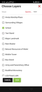
This app is very simple where users may access/ visualize the app with satellite images. This app contain the information of MC Shimla Himachal Pradesh: - 1) Basic utilities within 2) Find the location 3) shortest route w.r.t rescue team 4) Resource Mapping 5) detail of councilors 6) NDMA guidelines w.r.t Disaster 6) Ward Boundaries.
#GIS_Maping_Shimla
#MC_Shimla
#Disaster_Plan_Shimla
#Mobile_App_Shimla
#SDMA
This app is very simple where users may access/ visualize the app with satellite images. This app contain the information of MC Shimla Himachal Pradesh: - 1) Basic utilities within 2) Find the location 3) shortest route w.r.t rescue team 4) Resource Mapping 5) detail of councilors 6) NDMA guidelines w.r.t Disaster 6) Ward Boundaries.
Show More