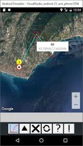
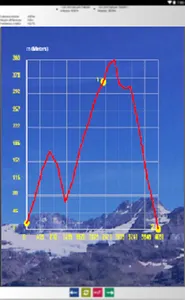
Graphic Altimeter measures and calculates elevations between N points of the terrain, with N from 2 to 99, even at great distances; it can also perform measurements between points not visible from each other, for example between mountains, and also measures the depth of the sea.
The application calculates the distances between the points indicated and displays the Cartesian curve of the heights measured in meters or feet.
Contains the following features: altimeter, depth gauge, trekking, distance, altitude, coordinates, speed, compass
The application calculates the distances between the points indicated and displays the Cartesian curve of the heights measured in meters or feet.
Contains the following features: altimeter, depth gauge, trekking, distance, altitude, coordinates, speed, compass
Show More