Hiking Map Poland
Mapa Turystyczna sp. z o.o.
4.6 ★
21K ratings
1,000,000+
downloads
Free
+ in-app
In this hiking map app, you can plan routes, navigate trails, and record tracks. Includes detailed topographic maps, points of interest, and offline map downloads.
AppRecs review analysis
AppRecs rating 4.6. Trustworthiness 81 out of 100. Review manipulation risk 18 out of 100. Based on a review sample analyzed.
★★★★☆
4.6
AppRecs Rating
Ratings breakdown
5 star
84%
4 star
9%
3 star
0%
2 star
0%
1 star
6%
What to know
✓
Low review manipulation risk
18% review manipulation risk
✓
Credible reviews
81% trustworthiness score from analyzed reviews
✓
High user satisfaction
84% of sampled ratings are 5 stars
About Hiking Map Poland
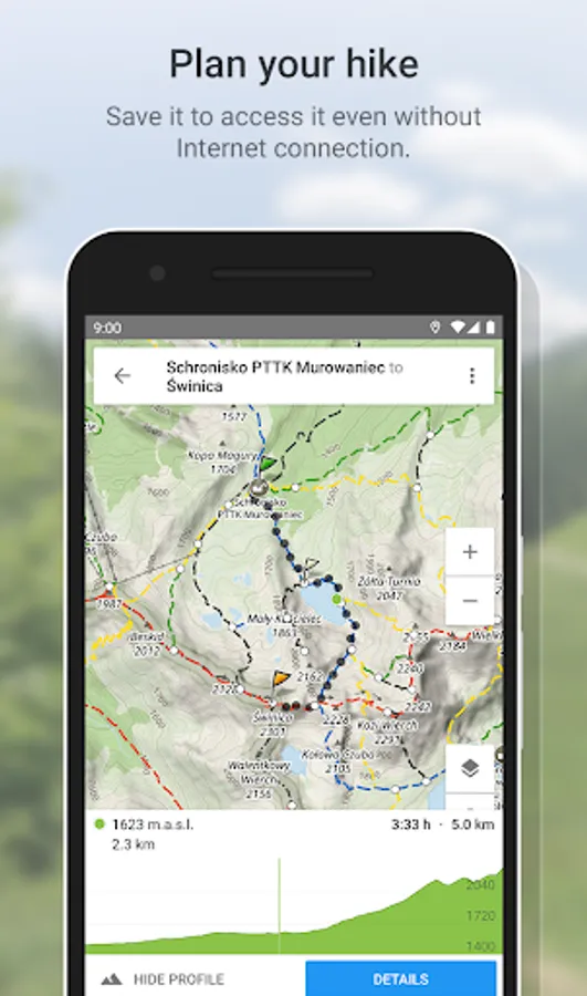
Route planning
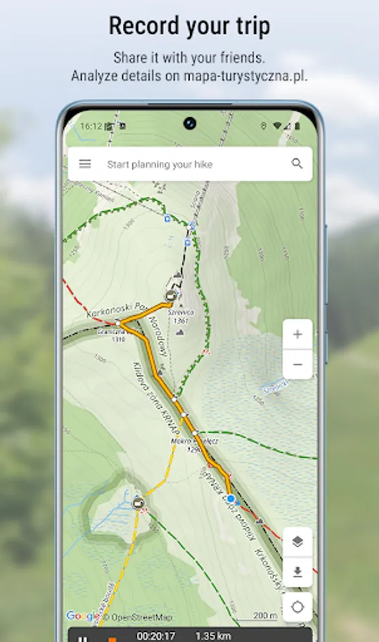
The main functionality is planning routes leading along official hiking trails in the mountains and foothills of Poland. The app finds a route quick and easy, displays it on a map, shows its length, estimated time, detailed course and elevation profile. It also shows your current location.
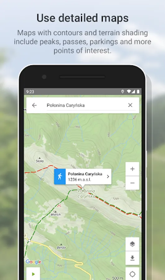
Detailed Touristic map layer with contours and terrain shading contains peaks, passes, parkings and other points of interest. In Premium version user can download maps of regions listed further in this description and use them offline.
Tracks recording
Second main functionality is recording tracks. You can then share it with your friends!
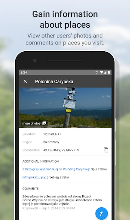
Interesting places
The app also displays information about points of interest: photos and opinions taken from the mapa-turystyczna.pl website.
Detailed functionalities:
- planning routes based on given points; points can be chosen from map or found using the search box,
- intelligent search suggestions, considering spots closest to your location and those most popular,
- displaying routes on a map along with their length, estimated time, route details (spots and trails) and elevation profile,
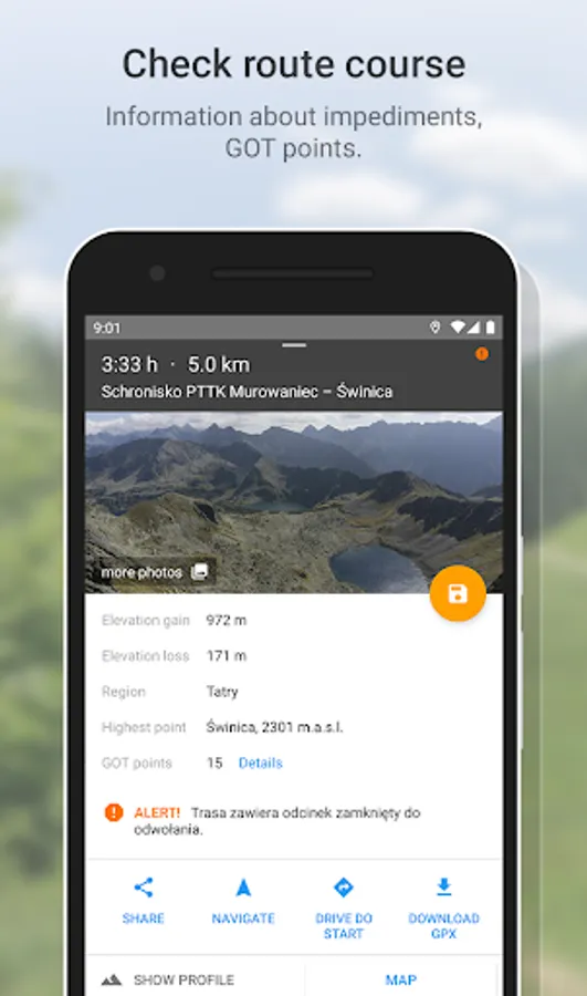
- information about impediments on route,
- GOT points for planned route,
- showing your current location on the map,
- compass,
- track recording, showing elapsing distance and time,
- list of recorded tracks,
- searching for places and showing them on the map,
- displaying information about places your searched for: photos and opinions taken from mapa-turystyczna.pl website,
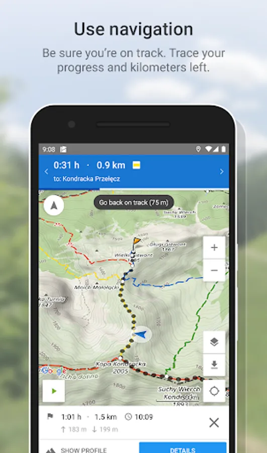
- navigation on planned route,
- detailed touristic maps layer, also available for download.
Available trails from i.e. regions:
* Beskidy
** Beskid Makowski
** Beskid Mały
** Beskid Niski
** Beskid Sądecki
** Beskid Śląski
** Beskid Śląsko-Morawski
** Beskid Wyspowy
** Beskid Żywiecki
** Bieszczady
** Gorce
* Sudety (Sudeten)
** Góry Bardzkie
** Góry Bystrzyckie
** Góry Orlickie
** Góry Izerskie
** Góry Kaczawskie
** Góry Kamienne
** Góry Opawskie
** Góry Sowie
** Góry Stołowe (Table Mountains)
** Góry Wałbrzyskie
** Góry Złote
** Góry Bialskie
** Karkonosze
** Kotlina Jeleniogórska
** Masyw Śnieżnika
** Rudawy Janowickie
* Pogórze Sudeckie
** Pogórze Izerskie
** Pogórze Kaczawskie
* Przedgórze Sudeckie
** Masyw Ślęży
** Przedgórze Paczkowskie
** Równina Świdnicka
** Wzgórza Niemczańsko-Strzelińskie
** Wzgórza Strzegomskie
* Pogórze Beskidzkie
** Pogórze Ciężkowickie
** Pogórze Przemyskie
** Pogórze Rożnowskie
** Pogórze Strzyżowskie
** Pogórze Dynowskie
** Pogórze Wielickie
** Pogórze Wiśnickie
* Other
** Wolin Island
** Góry Świętokrzyskie
** Płaskowyż Suchedniowski
** Kampinos Forest
** Jura Krakowsko-Częstochowska
** Brama Krakowska (Cracow's surroundings)
** Pieniny
** Pogórza Przedtatrzańskie
** Działy Orawskie
** Tatry (Tatra Mountains)
* Slovakia
** Góry Choczańskie (Choč Mountains)
** Skoruszyńskie Wierchy
** Góry Kysuckie (Kysuce Highlands)
** Magura Orawska (Orava Magura)
** Magura Spiska (Spiš Magura)
** Mała Fatra (Lesser Fatra)
** Niżne Tatry (Low Tatra Mountains)
** Słowacki Raj (Slovak Paradise)
** Wielka Fatra (Great Fatra)
** Wysokie Tatry (High Tatra Mountains)
App is free. Planning routes and displaying information about places need internet connection. Downloading offline maps and navigation are available in Premium (paid).
Hiking Map Poland Screenshots
Tap to Rate:
Reviews for Hiking Map Poland
Piotr Kuras
9/27/2025
Jedna gwiazdka za mapy offline, za które trzeba zapłacić a nie pokazują czasu dojścia do punktu z aktualnej pozycji (aplikacja niby wie gdzie jestem). Poza tym mapy tzw. offline nie ładują się bez połączenia z internetem.
Jelonek Games
9/11/2025
Widać, że pisali programiści za pół litra. Zero cache, okropnie działa, trasy pokazują zły czas, UI/UX totalnie leży. Nie polecam. Już wersja webowa jest lepsza.