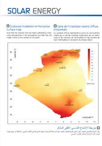
Before establishing a solar system, estimating the solar reservoir is critical. With Algeria has an estimated geographical area
B (2) million and (381) thousand and (741) square kilometers, it enjoys a huge source of solar energy deposited in its sky. There are only a few measurement stations that ensure the measurement of solar radiation. This Algerian solar atlas, which was based on the analysis of multi-source data over a period of (37) years.
Is an hourly data, obtained from celestial radiation meters or measurements for retrospective analysis of research and applications (2), NASA satellites that are paired with theoretical models of radiation transmission where measurements are not available inaccessible places, and the absence of radio stations to measure radiation Solar. These data cover the entire globe at an angle of (0.5) degrees (50) km Maps in this atlas represent the climate averages calculated over a period of forty years of monthly, annual and seasonal rates of accumulation of daily solar radiation.
Show More