Geoportal of the Samara region provides digital maps of the region's territory in wide access, as well as a medium for the creation and exchange of spatial data by users.
The basis of the geoportal is the open part of the Unified digital cartographic base of the Samara region (ETSKO), which is on duty on an ongoing basis in municipalities and the central node of the regional geographic information system. ETSKO includes buildings and structures (with an accuracy "to the house" in all settlements), street network, vegetation, hydrography, administrative divisions, space images and other layers.
On the basis of ETSKO, projects have been created to provide official thematic maps in the field of agriculture, nature management, hunting management, maps of social infrastructure facilities, as well as KSDM. All maps are maintained by the relevant ministries and are provided to users officially and on an ongoing basis.
Additionally, open external data sources from the Internet were connected - a map of land plots from the Rosreestr portal, high-resolution satellite images.
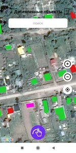
The user can:
- walk through the sections of the geoportal,
- watch digital maps,
- use address search,
- receive information about the object,
- view related documents and photos.
Some functions are available only to registered users, so we recommend that you go through authorization and get access to your personal account, where you can set up the composition of the cards as you wish, select tools, create layers, manage access rights to them, administer and moderate your maps and objects.
The basis of the geoportal is the open part of the Unified digital cartographic base of the Samara region (ETSKO), which is on duty on an ongoing basis in municipalities and the central node of the regional geographic information system. ETSKO includes buildings and structures (with an accuracy "to the house" in all settlements), street network, vegetation, hydrography, administrative divisions, space images and other layers.
On the basis of ETSKO, projects have been created to provide official thematic maps in the field of agriculture, nature management, hunting management, maps of social infrastructure facilities, as well as KSDM. All maps are maintained by the relevant ministries and are provided to users officially and on an ongoing basis.
Additionally, open external data sources from the Internet were connected - a map of land plots from the Rosreestr portal, high-resolution satellite images.
The user can:
- walk through the sections of the geoportal,
- watch digital maps,
- use address search,
- receive information about the object,
- view related documents and photos.
Some functions are available only to registered users, so we recommend that you go through authorization and get access to your personal account, where you can set up the composition of the cards as you wish, select tools, create layers, manage access rights to them, administer and moderate your maps and objects.
Show More