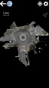
Coupled with the Syslor GNSS receiver, this application, designed for field operators, allows them to visualise 3D models in Augmented Reality (project utility networks, existing utility networks, road projects, BIM projects, etc). The main features are :
- Tracing of buried networks
- Object attributes (type/actual depth/diameter)
- Distance travelled counter
- Manage the display of your objects
- Visualising your trenches in Augmented Reality following the survey on the Syslor Récolement application
Additional features :
- Possible adaptation with your GIS
- Management of topographic coordinate systems
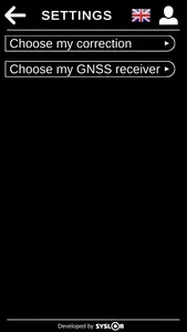
To use the application, you must have :
- An account on the Syslor portal (https://portalsyslor.com/fr)
- A Syslor GNSS receiver
- An "Augmented Reality" type subscription
Any questions? Contact us (https://syslor.net/contactfr/)
- Tracing of buried networks
- Object attributes (type/actual depth/diameter)
- Distance travelled counter
- Manage the display of your objects
- Visualising your trenches in Augmented Reality following the survey on the Syslor Récolement application
Additional features :
- Possible adaptation with your GIS
- Management of topographic coordinate systems
To use the application, you must have :
- An account on the Syslor portal (https://portalsyslor.com/fr)
- A Syslor GNSS receiver
- An "Augmented Reality" type subscription
Any questions? Contact us (https://syslor.net/contactfr/)
Show More