Watch Duty: Wildfire Maps
Sherwood Forestry Service, Inc.
4.9 ★
36K ratings
Free
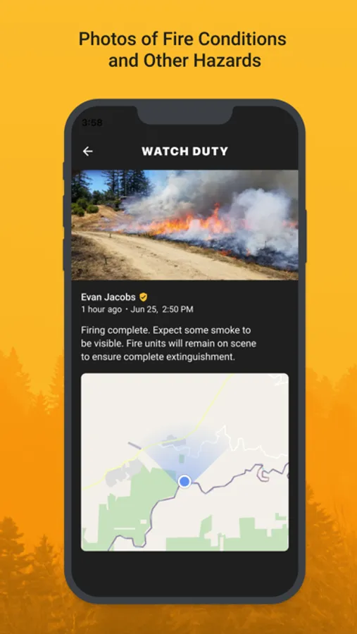
In this wildfire mapping app, users can receive real-time alerts, view active fire perimeters, and track firefighting efforts. Includes push notifications, satellite hotspots, wind data, evacuation info, and historical fire data.
AppRecs review analysis
AppRecs rating 4.5. Trustworthiness 0 out of 100. Review manipulation risk 0 out of 100. Based on a review sample analyzed.
★★★★☆
4.5
AppRecs Rating
Ratings breakdown
5 star
95%
4 star
3%
3 star
1%
2 star
0%
1 star
0%
What to know
✓
High user satisfaction
95% of sampled ratings are 5 stars
About Watch Duty: Wildfire Maps
Watch Duty is the only wildfire mapping and alert app powered by real people giving you real-time information vetted by trained professionals, not robots. While many other apps rely solely on government alerts, which can often be delayed, Watch Duty provides up-to-the-minute, life-saving information through a dedicated team of active and retired firefighters, dispatchers, first responders, and reporters who monitor radio scanners around the clock. We aim to keep you informed and safe with real-time updates and alerts.
Wildfire Tracking Features:
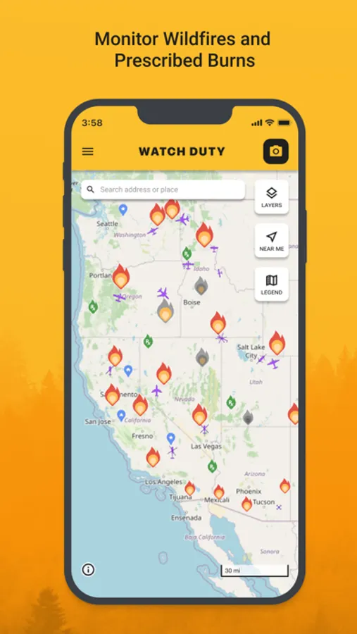
- Push notifications about nearby wildfires and firefighting efforts
- Real-time updates as conditions change
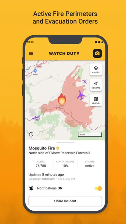
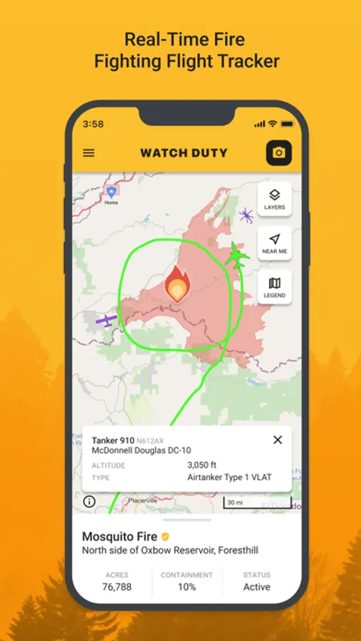
- Active fire perimeters and progress
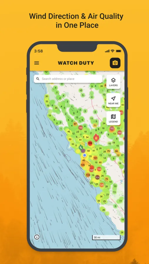
- Infrared satellite hotspots from VIIRS and MODIS
- Wind speed and direction
- Evacuation orders & shelter information
- Historical wildfire perimeters
- Street and satellite maps
- Air attack and air tanker flight tracker
- Save locations for quick access on the map
Watch Duty is a 501(c)(3) non-profit organization. Our service will always remain free of charge and free of advertising or sponsorship. You can support our mission with a $25/year membership, which grants access to special features as a token of our appreciation.
Disclaimer: Watch Duty is not affiliated with any government agency. The information provided in this app is sourced from publicly available and trusted sources, including but not limited to government agencies, radio transmissions, and satellite data.
For more information or support, feel free to contact us at support.watchduty.org.
Privacy Policy: https://www.watchduty.org/legal/privacy-policy
Terms of Use: https://www.apple.com/legal/internet-services/itunes/dev/stdeula/
Wildfire Tracking Features:
- Push notifications about nearby wildfires and firefighting efforts
- Real-time updates as conditions change
- Active fire perimeters and progress
- Infrared satellite hotspots from VIIRS and MODIS
- Wind speed and direction
- Evacuation orders & shelter information
- Historical wildfire perimeters
- Street and satellite maps
- Air attack and air tanker flight tracker
- Save locations for quick access on the map
Watch Duty is a 501(c)(3) non-profit organization. Our service will always remain free of charge and free of advertising or sponsorship. You can support our mission with a $25/year membership, which grants access to special features as a token of our appreciation.
Disclaimer: Watch Duty is not affiliated with any government agency. The information provided in this app is sourced from publicly available and trusted sources, including but not limited to government agencies, radio transmissions, and satellite data.
For more information or support, feel free to contact us at support.watchduty.org.
Privacy Policy: https://www.watchduty.org/legal/privacy-policy
Terms of Use: https://www.apple.com/legal/internet-services/itunes/dev/stdeula/
Watch Duty: Wildfire Maps Screenshots
Tap to Rate:
Reviews for Watch Duty: Wildfire Maps
elizasmind
Knowledge is power
Knowing where fires are helps me prepare and feel safe.
VenturaMan
Watch Duty is a Godsend
The people at Watch Duty are my next favorite people, only after the firefighters themselves! It’s such a relief to have timely information about the fires that ravage our state. I wouldn’t be without the app in these times.