AppRecs review analysis
AppRecs rating 5.0. Trustworthiness 0 out of 100. Review manipulation risk 0 out of 100. Based on a review sample analyzed.
★★★★★
5.0
AppRecs Rating
Ratings breakdown
5 star
100%
4 star
0%
3 star
0%
2 star
0%
1 star
0%
What to know
✓
High user satisfaction
100% of sampled ratings are 5 stars
About SkyNav
SkyNav is the sophisticated drone mapping and airspace awareness solution for pilots across Canada, the USA, the UK, Germany, and Australia. Designed for both professional operators and dedicated enthusiasts, SkyNav provides comprehensive tools for informed flight planning and enhanced aerial operations.
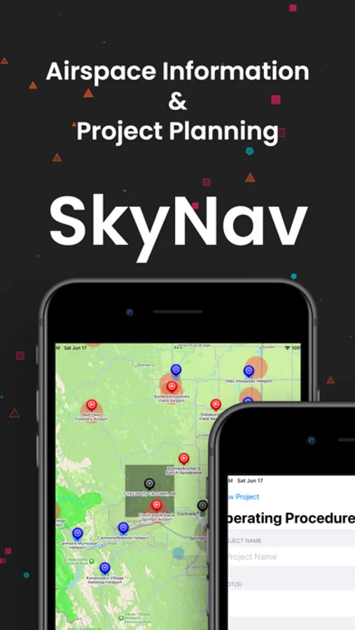
• Comprehensive Airspace Mapping: Navigate confidently with detailed interactive maps spanning five countries across three continents. Access critical information on aerodromes, airports, heliports, national parks, and designated no-fly zones to make informed decisions about your flight locations.
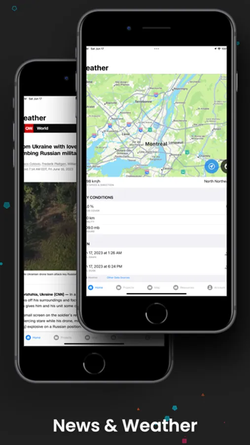
• Strategic Weather Intelligence: Plan optimal flight conditions with location-specific weather forecasting, delivering real-time meteorological data tailored to each region's unique atmospheric patterns.
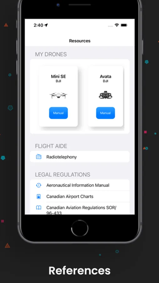
• Multi-National Resource Center: Access a centralized knowledge base of aeronautical information, including references to aviation guidelines and drone operation best practices for all supported regions—Canada, the USA, the UK, Germany, and Australia.
• Integrated Operations Management: Enhance your operational efficiency with intuitive tools for flight planning, tracking, and documentation. Maintain organized records of your drone equipment, flight logs, and certifications across multiple regions.
• SkyView Professional Network: Connect with the SkyNav community through our exclusive SkyView platform. Share aerial footage securely with fellow professionals, discover innovative techniques, and explore high-quality drone content from diverse geographical locations.
• Enhanced Data Protection: Operate with confidence knowing your professional data and content are protected by robust security measures, allowing you to focus on expanding your aerial capabilities.
SkyNav delivers a comprehensive solution for international drone operations. Whether you're planning complex flight paths, documenting your aerial portfolio, or seeking inspiration from fellow professionals, SkyNav provides the sophisticated tools required for success.
Download SkyNav today to elevate your professional drone operations.
By using this app, you agree to Apple's standard Licensed Application End User License Agreement (EULA): https://www.apple.com/legal/internet-services/itunes/dev/stdeula/
• Comprehensive Airspace Mapping: Navigate confidently with detailed interactive maps spanning five countries across three continents. Access critical information on aerodromes, airports, heliports, national parks, and designated no-fly zones to make informed decisions about your flight locations.
• Strategic Weather Intelligence: Plan optimal flight conditions with location-specific weather forecasting, delivering real-time meteorological data tailored to each region's unique atmospheric patterns.
• Multi-National Resource Center: Access a centralized knowledge base of aeronautical information, including references to aviation guidelines and drone operation best practices for all supported regions—Canada, the USA, the UK, Germany, and Australia.
• Integrated Operations Management: Enhance your operational efficiency with intuitive tools for flight planning, tracking, and documentation. Maintain organized records of your drone equipment, flight logs, and certifications across multiple regions.
• SkyView Professional Network: Connect with the SkyNav community through our exclusive SkyView platform. Share aerial footage securely with fellow professionals, discover innovative techniques, and explore high-quality drone content from diverse geographical locations.
• Enhanced Data Protection: Operate with confidence knowing your professional data and content are protected by robust security measures, allowing you to focus on expanding your aerial capabilities.
SkyNav delivers a comprehensive solution for international drone operations. Whether you're planning complex flight paths, documenting your aerial portfolio, or seeking inspiration from fellow professionals, SkyNav provides the sophisticated tools required for success.
Download SkyNav today to elevate your professional drone operations.
By using this app, you agree to Apple's standard Licensed Application End User License Agreement (EULA): https://www.apple.com/legal/internet-services/itunes/dev/stdeula/
SkyNav Screenshots

Tap to Rate:
Reviews for SkyNav
S. Rome
Great App!
Useful for my flights and I enjoyed that it’s free!
Marcus Santos-Rivera
Would love a USA version!
This app looks so clean and intuitive. Really feels like Apple released it. Definitely need the developer to release a US version for us to down south.