BaseMap: Hunting Maps and GPS
BaseMap Inc
4.1 ★
5K ratings
500,000+
downloads
Free
+ in-app
In this GPS mapping app, you can access detailed land ownership data, plan hunts, and navigate using GPS features. Includes offline map storage, weather updates, wind forecasts, and real-time location sharing.
AppRecs review analysis
AppRecs rating 3.8. Trustworthiness 84 out of 100. Review manipulation risk 17 out of 100. Based on a review sample analyzed.
★★★☆☆
3.8
AppRecs Rating
Ratings breakdown
5 star
60%
4 star
16%
3 star
5%
2 star
5%
1 star
13%
What to know
✓
Low review manipulation risk
17% review manipulation risk
✓
Credible reviews
84% trustworthiness score from analyzed reviews
⚠
Pricing complaints
Many low ratings mention paywalls or pricing
About BaseMap: Hunting Maps and GPS
Land ownership maps, hunt planning, navigation, GPS, wind, weather, and field tools all in one convenient app.
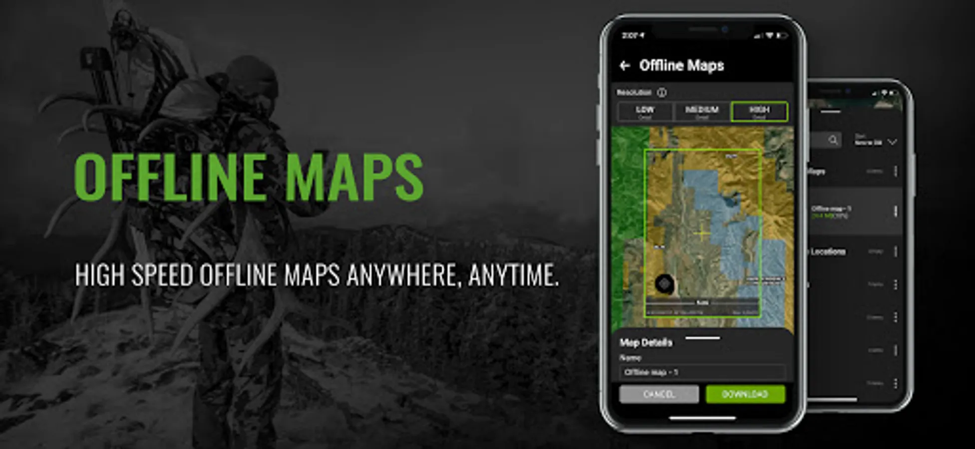
OFFLINE GPS and TRACKING
• Save maps for offline use without service
• Know exactly where you are in real time even without cellular coverage
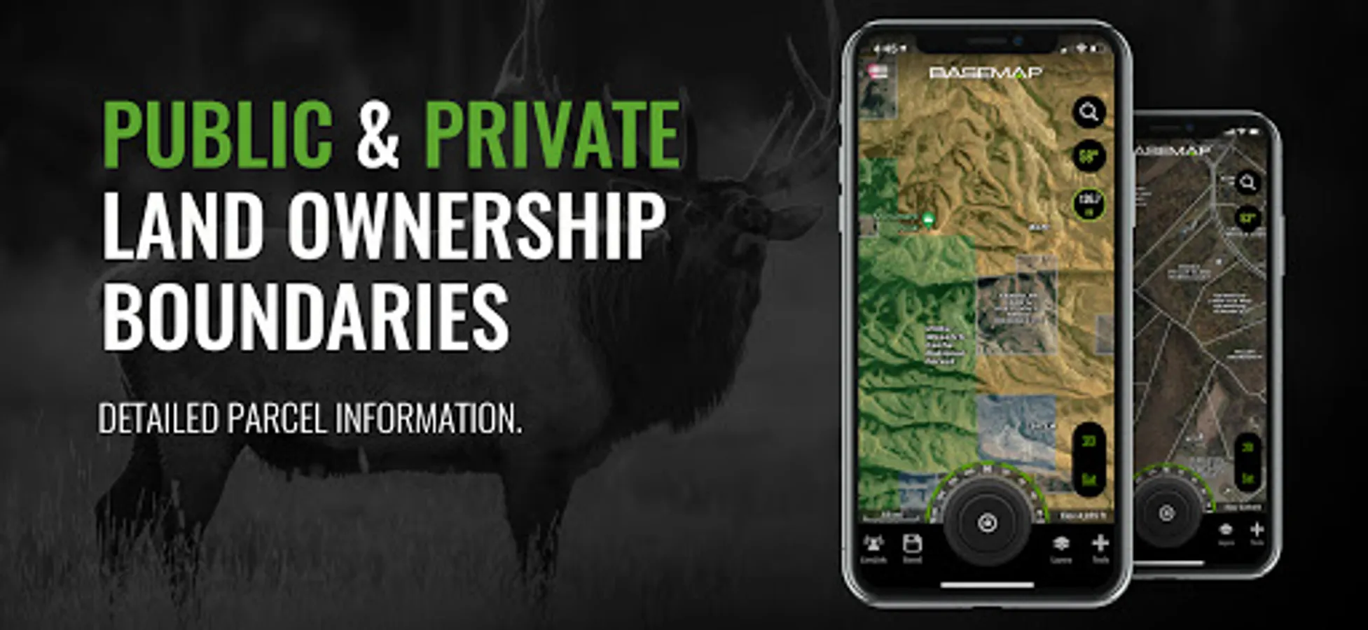
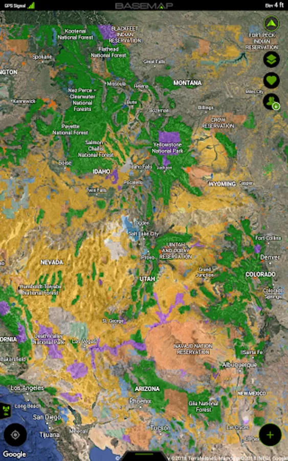
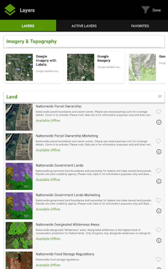
MAP LAYERS
• 900 layers and growing
• Nationwide Color Coded Govt Lands
• Nationwide Private Parcel Boundaries & Owner Names
• Coastal Water Depths & over 4,000 U.S. lakes
• Nationwide Hiking Trails
• Nationwide Wildfires & Timber cuts
• Nationwide Wilderness & Roadless Areas
• State hunting layers (boundaries, WMA’s, habitat, etc)
• Multiple Topography & Satellite Imagery basemap options
• Much more
DESKTOP & MOBILE HUNT PLANNER
• Unit filtering
• Draw odds
• Harvest data
• Season dates
• Unit insights
LRF MAPPING (Laser Rangefinder Mapping)
• Use your rangefinder as a powerful mapping tool
• Precisely mark the exact location of distant targets with ANY rangefinder
• Recover game, plan stalks, lookup distant property owners and more, all using your rangefinder
MOBILE GPS
• Know your exact location even without cellular or WiFi service
• See where you are in relation to landmarks, boundaries, roads, trails, etc
• Navigate to trailheads, favorite places, markers, or anything you need to locate with our powerful Search and GoTo features.
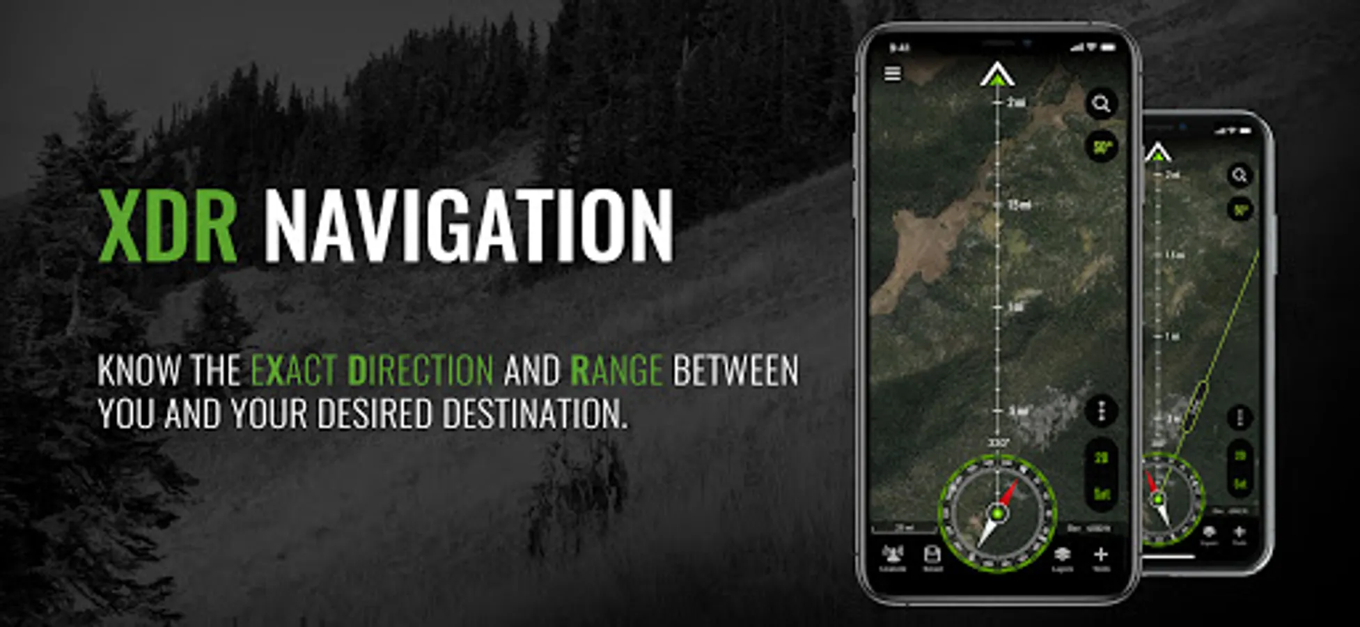
XDR (Exact Direction & Range) NAVIGATION TOOL
• Easy Point and Go navigation
• Know the exact distance between you and your destination.
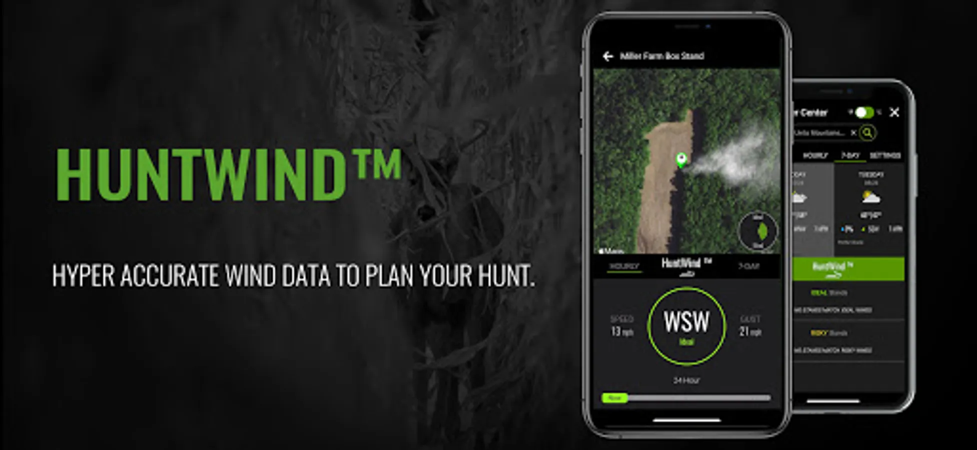
HUNTWIND & WEATHER CENTER
• Wind forecast to better plan your hunt.
• Know the exact day and time to hunt a particular stand and visualize wind direction and scent drift in relation to your location.
• Forecasts, temperature, moon phase, sunrise/sunset, wind, and more.
LOCATION SHARING
• Know exactly where your hunting partner is located
• Real-time updates
OUTDOOR JOURNAL
• Capture, log, and share all your outdoor adventures with the BaseMap community
• Real-time location sharing so friends can see where you are in case of emergency (connection reqd.)
• SmartMarkers - Automatically capture the weather conditions at the time you add a marker.
•
HARVEST LOG
• Log your hunts as detailed as you'd like. Record your hunt type, species/size, weapon, unit/GMU & much more.
GOOGLE EARTH INTEGRATION
• Export markers and view them right in Google Earth
• View the terrain in true 3D
SUBSCRIPTIONS
BASIC (Free)
• No Ads
• Connect with friends
• Hybrid 3D Imagery (map tilt).
• XDR Navigation
• Nationwide Roads, Trails & Points of Interest
• Nationwide Lakes, Rivers & Streams
• Hunting Unit boundaries
• GPS Location & Tracking
• Hi-Res Satellite Imagery
PRO ($39.99/yr)
• Everything in Basic plan
• Access to over 800 Layers
• Unlimited Data & Offline Use
• Nationwide parcel boundaries and owner names
• Nationwide color-coded government lands
• Google Earth Integration
• Import/Export KML and GPX with BaseMap web application
• Real-Time location sharing
• LRF Mapping (Laser Rangefinder Mapping)
• Discounted private land hunts
PRO ADVANTAGE ($69.99/yr)
• BaseMap Pro subscription
• Discounted private land hunts
• Global Rescue field advisory and rescue services
PRO ULTIMATE ($99.99/yr)
Includes:
• BaseMap Pro
• Discounted private land hunts
• Global Rescue field advisory and rescue services
• Hunt Planner: Unit filtering, draw odds, harvest data, season dates, and more
For questions, contact us at: support@basemap.com
Privacy policy: https://www.basemap.com/privacy-policy/
Terms of use: https://www.basemap.com/terms-of-use/
Government Information: BaseMap Inc does not represent any government or political entity, though you may find various links to public information within our services. For more info on any government information found within the services, click on the associated .gov link.
https://data.fs.usda.gov/geodata/
https://gbp-blm-egis.hub.arcgis.com/
OFFLINE GPS and TRACKING
• Save maps for offline use without service
• Know exactly where you are in real time even without cellular coverage
MAP LAYERS
• 900 layers and growing
• Nationwide Color Coded Govt Lands
• Nationwide Private Parcel Boundaries & Owner Names
• Coastal Water Depths & over 4,000 U.S. lakes
• Nationwide Hiking Trails
• Nationwide Wildfires & Timber cuts
• Nationwide Wilderness & Roadless Areas
• State hunting layers (boundaries, WMA’s, habitat, etc)
• Multiple Topography & Satellite Imagery basemap options
• Much more
DESKTOP & MOBILE HUNT PLANNER
• Unit filtering
• Draw odds
• Harvest data
• Season dates
• Unit insights
LRF MAPPING (Laser Rangefinder Mapping)
• Use your rangefinder as a powerful mapping tool
• Precisely mark the exact location of distant targets with ANY rangefinder
• Recover game, plan stalks, lookup distant property owners and more, all using your rangefinder
MOBILE GPS
• Know your exact location even without cellular or WiFi service
• See where you are in relation to landmarks, boundaries, roads, trails, etc
• Navigate to trailheads, favorite places, markers, or anything you need to locate with our powerful Search and GoTo features.
XDR (Exact Direction & Range) NAVIGATION TOOL
• Easy Point and Go navigation
• Know the exact distance between you and your destination.
HUNTWIND & WEATHER CENTER
• Wind forecast to better plan your hunt.
• Know the exact day and time to hunt a particular stand and visualize wind direction and scent drift in relation to your location.
• Forecasts, temperature, moon phase, sunrise/sunset, wind, and more.
LOCATION SHARING
• Know exactly where your hunting partner is located
• Real-time updates
OUTDOOR JOURNAL
• Capture, log, and share all your outdoor adventures with the BaseMap community
• Real-time location sharing so friends can see where you are in case of emergency (connection reqd.)
• SmartMarkers - Automatically capture the weather conditions at the time you add a marker.
•
HARVEST LOG
• Log your hunts as detailed as you'd like. Record your hunt type, species/size, weapon, unit/GMU & much more.
GOOGLE EARTH INTEGRATION
• Export markers and view them right in Google Earth
• View the terrain in true 3D
SUBSCRIPTIONS
BASIC (Free)
• No Ads
• Connect with friends
• Hybrid 3D Imagery (map tilt).
• XDR Navigation
• Nationwide Roads, Trails & Points of Interest
• Nationwide Lakes, Rivers & Streams
• Hunting Unit boundaries
• GPS Location & Tracking
• Hi-Res Satellite Imagery
PRO ($39.99/yr)
• Everything in Basic plan
• Access to over 800 Layers
• Unlimited Data & Offline Use
• Nationwide parcel boundaries and owner names
• Nationwide color-coded government lands
• Google Earth Integration
• Import/Export KML and GPX with BaseMap web application
• Real-Time location sharing
• LRF Mapping (Laser Rangefinder Mapping)
• Discounted private land hunts
PRO ADVANTAGE ($69.99/yr)
• BaseMap Pro subscription
• Discounted private land hunts
• Global Rescue field advisory and rescue services
PRO ULTIMATE ($99.99/yr)
Includes:
• BaseMap Pro
• Discounted private land hunts
• Global Rescue field advisory and rescue services
• Hunt Planner: Unit filtering, draw odds, harvest data, season dates, and more
For questions, contact us at: support@basemap.com
Privacy policy: https://www.basemap.com/privacy-policy/
Terms of use: https://www.basemap.com/terms-of-use/
Government Information: BaseMap Inc does not represent any government or political entity, though you may find various links to public information within our services. For more info on any government information found within the services, click on the associated .gov link.
https://data.fs.usda.gov/geodata/
https://gbp-blm-egis.hub.arcgis.com/
BaseMap: Hunting Maps and GPS Screenshots


Tap to Rate:
Reviews for BaseMap: Hunting Maps and GPS
Wayne Morgan
12/28/2025
crashing can't open
John Bailey
12/23/2025
false advertising