GPS Map Camera Navigation Tag
Pentabit Apps
10,000+
downloads
Free
+ in-app
AppRecs review analysis
AppRecs rating 4.0. Trustworthiness 55 out of 100. Review manipulation risk 44 out of 100. Based on a review sample analyzed.
★★★★☆
4.0
AppRecs Rating
Ratings breakdown
5 star
100%
4 star
0%
3 star
0%
2 star
0%
1 star
0%
What to know
⚠
Questionable review patterns
44% review manipulation risk - some review patterns appear unusual
⚠
Unusually uniform ratings
100% of sampled ratings are 5 stars with very little variation
About GPS Map Camera Navigation Tag
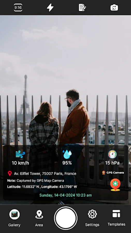
Capture every stop with precision using GPS Camera Stamp Location Tag, a GPS camera and geotagging app built for truckers, freight drivers, and on-road professionals. Add location, time, and map data to every photo with high accuracy and clean, organized output.
Use the app to geotag images with location stamps, date, and time—perfect for documenting deliveries, roadside stops, rest areas, and loading points. Whether you're driving across states or handling short-haul routes, this tool lets you maintain location-based visual records without manual entry.
Core Features
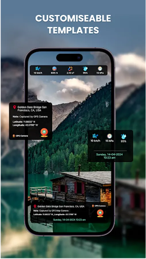
• GPS tag every photo with latitude, longitude, and timestamp
• Display road, satellite, or hybrid map views in each image
• Add address and location metadata automatically
• Organize photos with truck-relevant geotags
• Use for delivery logs, load documentation, and inspection records
• Fast photo tagging with GPS info for truck GPS and navigation tracking
• Support for tagging weigh stations, rest stops, or custom locations
• Useful for truckers logging miles or verifying route checkpoints
Truck-Optimized Use Cases
• Snap a photo at every delivery or pickup point with automatic location info
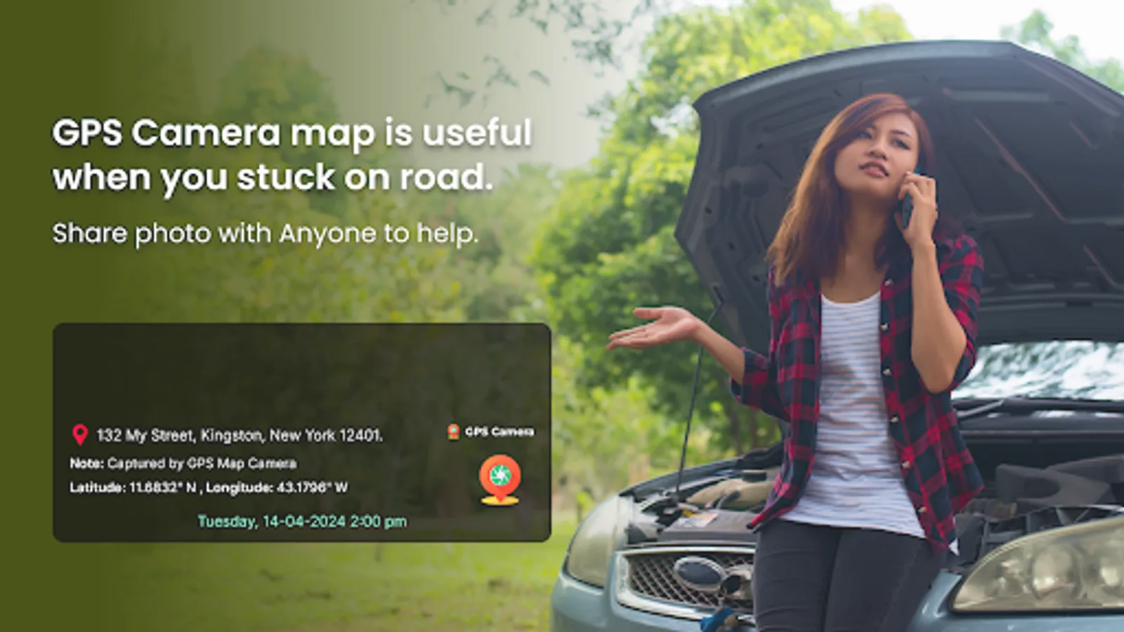
• Record roadside events or inspections with embedded data
• Keep a digital log of stops with geotagged images
• Use as supporting records for dispatch, compliance, or proof-of-stop
This app fits naturally into the workday of any US-based trucker. From long-haul operators to regional drivers, it provides an efficient method for creating visual records tied to real GPS coordinates.
Compatible with truck routing workflows and useful alongside truck GPS systems, map-based trip planning tools, and trucking dispatch platforms. You can also use it with your own vehicle navigation and mapping setup for extra verification.
Built For
• Truck drivers needing accurate, timestamped photo documentation
• Owner-operators tracking trips with visual proof
• Route managers needing precise photo logs of location-based activities
• Fleets and logistics teams who want reliable records from the road
Whether you're tagging rest areas, documenting stops, or recording load drop-offs, GPS Camera Stamp Location Tag simplifies photo-based tracking with location stamps optimized for trucking tasks.
Download now to add reliable GPS tagging to every picture you take on the road.
Use the app to geotag images with location stamps, date, and time—perfect for documenting deliveries, roadside stops, rest areas, and loading points. Whether you're driving across states or handling short-haul routes, this tool lets you maintain location-based visual records without manual entry.
Core Features
• GPS tag every photo with latitude, longitude, and timestamp
• Display road, satellite, or hybrid map views in each image
• Add address and location metadata automatically
• Organize photos with truck-relevant geotags
• Use for delivery logs, load documentation, and inspection records
• Fast photo tagging with GPS info for truck GPS and navigation tracking
• Support for tagging weigh stations, rest stops, or custom locations
• Useful for truckers logging miles or verifying route checkpoints
Truck-Optimized Use Cases
• Snap a photo at every delivery or pickup point with automatic location info
• Record roadside events or inspections with embedded data
• Keep a digital log of stops with geotagged images
• Use as supporting records for dispatch, compliance, or proof-of-stop
This app fits naturally into the workday of any US-based trucker. From long-haul operators to regional drivers, it provides an efficient method for creating visual records tied to real GPS coordinates.
Compatible with truck routing workflows and useful alongside truck GPS systems, map-based trip planning tools, and trucking dispatch platforms. You can also use it with your own vehicle navigation and mapping setup for extra verification.
Built For
• Truck drivers needing accurate, timestamped photo documentation
• Owner-operators tracking trips with visual proof
• Route managers needing precise photo logs of location-based activities
• Fleets and logistics teams who want reliable records from the road
Whether you're tagging rest areas, documenting stops, or recording load drop-offs, GPS Camera Stamp Location Tag simplifies photo-based tracking with location stamps optimized for trucking tasks.
Download now to add reliable GPS tagging to every picture you take on the road.