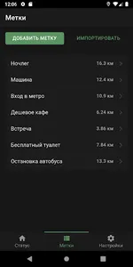
With GeoApp, you can create a list of geotags and always be able to find out how far they are and in which direction.
The application will be useful for fishermen, hunters, travelers, motorists (to search for their car in the parking lot), as well as all others who need to navigate in an unfamiliar area, reach a certain place or quickly save current coordinates.
Features:
- The application works completely without the Internet.
- For navigation, a built-in compass is used, and in its absence, data from GPS (in this case, you must constantly move).
- Display of current coordinates, altitude, speed, data accuracy and compass needle.
- Convenient import of coordinates.
- Ability to share your coordinates or show a place on the map.
- The distance and direction to each geo.
- Different units.
- A dark theme for comfortable night work.
Show More


