Multicarto provides easy access to a selection of reference maps on French territory, and practical and useful map functions, for simple or more advanced uses.
IN FREE AND FREE ACCESS ❤️
🗺️ Multi-scale IGN map
🗺️ Multi-scale OSM map
🗺️ Mixed (aerial photo and roads)
🗺️ Aerial photos
🗺️ Recreational drones and model aircraft
🗺️ Map of Cassini (18th)
🗺️ Military map (1866)
🗺️ Map 1950
🗺️ Aerial photo 1950
Free access features:
✔️ Saving points of interest (unlimited)
✔️ Import of data in KMLet GPX format (5 imports)
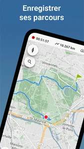
✔️ Course recording (5 courses)
✔️ Export of points of interest and routes in KML and GPX format
✔️ "Where am I?" gives you the complete address or the municipality of your location
✔️ Display of coordinates (in geographic, UTM, Lambert 93, Open Location formats)
✔️ Display of the altitude of a point on the map
✔️ Map sharing on social networks, sending by email, SMS, etc. So easily share a map extract with your position
✔️ With the sharing feature, also print your maps in compliance with the conditions of use of IGN data
IF YOU WISH, WITH THE PREMIUM SUBSCRIPTION ❤️❤️❤️
🥾 IGN hiking map (1:25,000)
🏰 Tourist Map (1:100,000)
🚘 Road map (1:1,000,000 and 1:250,000)
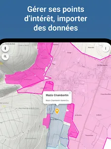
📐 Cadastre (source IGN and DGFiP)
🛩️ ICAO aeronautical chart
⛰️ Slope map
Premium Features
✔️ Save maps for offline viewing (off network, offline)
✔️ Unlimited imports
✔️ Unlimited route recording
✔️ Display of dimensions of cadastral parcels and their surfaces
➡️ About Premium Membership
Access to all maps and saving maps for offline viewing are free for 7 days.
Take the opportunity to test everything! Beyond this period, you will be invited to subscribe to the Premium subscription.
The subscription is made EXCLUSIVELY via the PlayStore: you thus benefit from all the security and confidentiality required for the purchase, and the flexibility for the payment: CB, gift card, payment on invoice of your operator, PayPal. .
❤️ If you don't want to take out a subscription, you can continue to use all open access features for free.
IMPORTANT 👓
- An internet connection is required for searching geographical locations, displaying elevation and presenting extended cadastral parcel information.
- Certain maps and content are distributed via the Geoportal (IGN Geoservices) or other data providers.
In the event of a display problem, you can use the "Quality of Services" link in the application to check that third-party services are working correctly.
- The application developer cannot intervene on the information present on the cards: any comments on a card should be made directly to the producer of the data.
- The cartographic contents are offered for information purposes only, with the exclusion of any guarantee as to their accuracy or their suitability for specific needs.
A request, a suggestion? Contact us at multicarto@utopoi.com!
Also, don't hesitate to tell us how you use Multicarto for your hobbies, studies or work 🙂
IN FREE AND FREE ACCESS ❤️
🗺️ Multi-scale IGN map
🗺️ Multi-scale OSM map
🗺️ Mixed (aerial photo and roads)
🗺️ Aerial photos
🗺️ Recreational drones and model aircraft
🗺️ Map of Cassini (18th)
🗺️ Military map (1866)
🗺️ Map 1950
🗺️ Aerial photo 1950
Free access features:
✔️ Saving points of interest (unlimited)
✔️ Import of data in KMLet GPX format (5 imports)
✔️ Course recording (5 courses)
✔️ Export of points of interest and routes in KML and GPX format
✔️ "Where am I?" gives you the complete address or the municipality of your location
✔️ Display of coordinates (in geographic, UTM, Lambert 93, Open Location formats)
✔️ Display of the altitude of a point on the map
✔️ Map sharing on social networks, sending by email, SMS, etc. So easily share a map extract with your position
✔️ With the sharing feature, also print your maps in compliance with the conditions of use of IGN data
IF YOU WISH, WITH THE PREMIUM SUBSCRIPTION ❤️❤️❤️
🥾 IGN hiking map (1:25,000)
🏰 Tourist Map (1:100,000)
🚘 Road map (1:1,000,000 and 1:250,000)
📐 Cadastre (source IGN and DGFiP)
🛩️ ICAO aeronautical chart
⛰️ Slope map
Premium Features
✔️ Save maps for offline viewing (off network, offline)
✔️ Unlimited imports
✔️ Unlimited route recording
✔️ Display of dimensions of cadastral parcels and their surfaces
➡️ About Premium Membership
Access to all maps and saving maps for offline viewing are free for 7 days.
Take the opportunity to test everything! Beyond this period, you will be invited to subscribe to the Premium subscription.
The subscription is made EXCLUSIVELY via the PlayStore: you thus benefit from all the security and confidentiality required for the purchase, and the flexibility for the payment: CB, gift card, payment on invoice of your operator, PayPal. .
❤️ If you don't want to take out a subscription, you can continue to use all open access features for free.
IMPORTANT 👓
- An internet connection is required for searching geographical locations, displaying elevation and presenting extended cadastral parcel information.
- Certain maps and content are distributed via the Geoportal (IGN Geoservices) or other data providers.
In the event of a display problem, you can use the "Quality of Services" link in the application to check that third-party services are working correctly.
- The application developer cannot intervene on the information present on the cards: any comments on a card should be made directly to the producer of the data.
- The cartographic contents are offered for information purposes only, with the exclusion of any guarantee as to their accuracy or their suitability for specific needs.
A request, a suggestion? Contact us at multicarto@utopoi.com!
Also, don't hesitate to tell us how you use Multicarto for your hobbies, studies or work 🙂
Show More