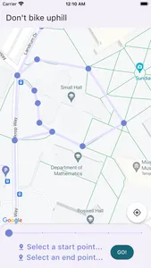
This app lets you find the best route between two places on William & Mary's campus to prevent you from having to bike uphill.
Relative barometric pressure data measurements were taken to determine small elevation changes at a variety of locations around William & Mary. This data has been converted into a weighted graph overlaid on a map of the campus. Locations across campus are selectable, and Dijkstra’s Algorithm is used to find the shortest path from source to destination, accounting for the user’s preference to avoid biking uphill. Results are displayed on the map.
Relative barometric pressure data measurements were taken to determine small elevation changes at a variety of locations around William & Mary. This data has been converted into a weighted graph overlaid on a map of the campus. Locations across campus are selectable, and Dijkstra’s Algorithm is used to find the shortest path from source to destination, accounting for the user’s preference to avoid biking uphill. Results are displayed on the map.
Show More


