AppRecs review analysis
AppRecs rating 2.5. Trustworthiness 68 out of 100. Review manipulation risk 24 out of 100. Based on a review sample analyzed.
★★☆☆☆
2.5
AppRecs Rating
Ratings breakdown
5 star
0%
4 star
0%
3 star
50%
2 star
0%
1 star
50%
What to know
✓
Low review manipulation risk
24% review manipulation risk
⚠
Mixed user feedback
Average 2.5★ rating suggests room for improvement
About Achilleus 3D Tactical Map
EXCLUSIVE DISCOUNT 30% OFF FOR A LIMITED TIME!!
*** Achilleus 3D is under active development and will have new features and improvements in the future. ***
Professional 3D Tactical Mapping for Military Operations
• Elevate your tactical planning and navigation with the most advanced 3D terrain visualization and military-grade GPS navigation app. Designed for military professionals, first responders, and tactical teams who demand precision and reliability.
ADVANCED TACTICAL MAPPING
• 3D Terrain Maps - Lifelike topographic visualization with elevation data for precise mission planning
• Offline Maps - Download and cache multiple map sources including satellite imagery for remote operations
• Military Grid Systems - Full support for MGRS, USNG, UTM, and British National Grid coordinates
• Multiple Map Sources - Virtual Earth, Google Satellite, OpenTopo, OpenStreetMap, ArcGIS, and Nokia maps
• Import and export KML/KMZ and GPX files.
MISSION-CRITICAL TOOLS
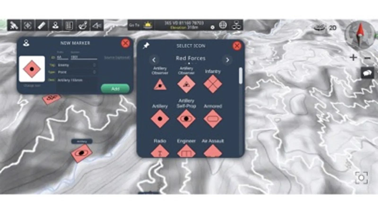
• Waypoint Navigation - Create unlimited GPS waypoints with military-standard accuracy
• Drawing Tools - Add tactical lines, polygons, and circles to visualize areas of interest
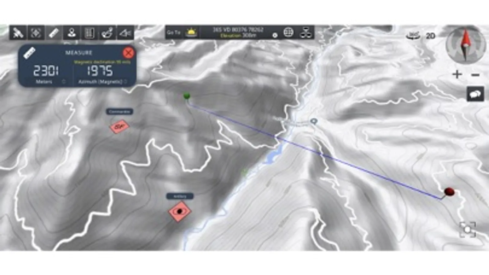
• Distance & Bearing - Measure in both degrees and mils for artillery and navigation calculations
• Real-time GPS - Precise coordinate display with multiple datum support
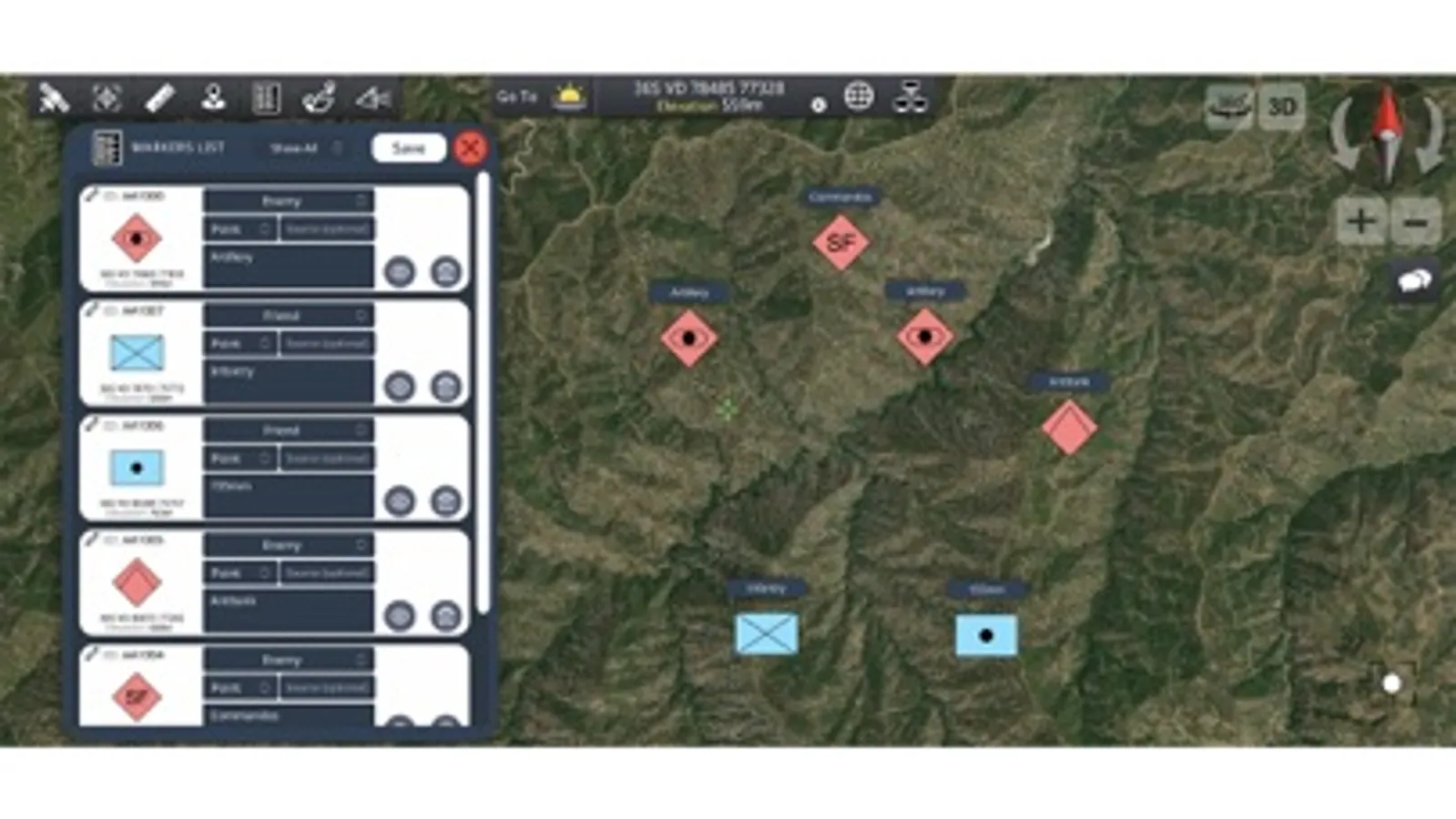
TACTICAL COMMUNICATION
• Network Sharing - Share live map status and markers over TCP/IP networks without external servers
• Team Chat - Built-in communication system for coordinated operations
• Real-time Monitoring - Track team member positions and activities on shared tactical maps
PROFESSIONAL FEATURES
• MIL-STD-2525D Symbology - Standard military symbols for tactical operations
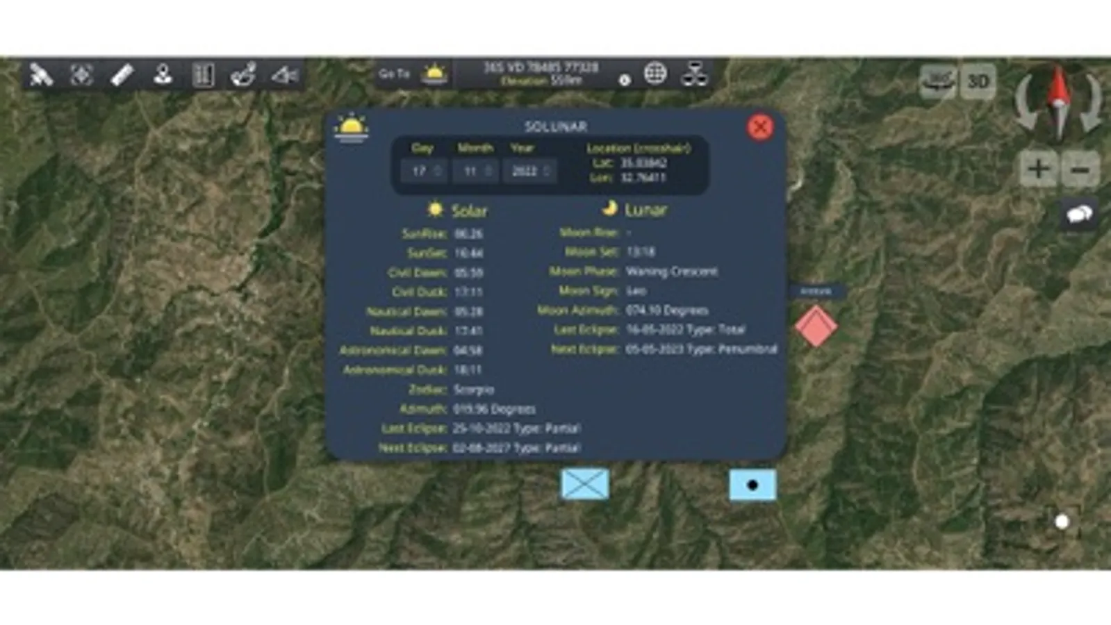
• Solar/Lunar Data - Complete astronomical information for mission timing
• Secure & Encrypted - Military-grade data protection
• One-hand Operation - Intuitive interface designed for field use
Perfect for:
• Military personnel and tactical units
• Search and rescue operations
• Law enforcement agencies
• Emergency response teams
• Outdoor professionals requiring precision navigation
Transform your tactical operations with professional-grade mapping technology. Download now and experience the difference precision makes in the field.
*** Achilleus 3D is under active development and will have new features and improvements in the future. ***
Professional 3D Tactical Mapping for Military Operations
• Elevate your tactical planning and navigation with the most advanced 3D terrain visualization and military-grade GPS navigation app. Designed for military professionals, first responders, and tactical teams who demand precision and reliability.
ADVANCED TACTICAL MAPPING
• 3D Terrain Maps - Lifelike topographic visualization with elevation data for precise mission planning
• Offline Maps - Download and cache multiple map sources including satellite imagery for remote operations
• Military Grid Systems - Full support for MGRS, USNG, UTM, and British National Grid coordinates
• Multiple Map Sources - Virtual Earth, Google Satellite, OpenTopo, OpenStreetMap, ArcGIS, and Nokia maps
• Import and export KML/KMZ and GPX files.
MISSION-CRITICAL TOOLS
• Waypoint Navigation - Create unlimited GPS waypoints with military-standard accuracy
• Drawing Tools - Add tactical lines, polygons, and circles to visualize areas of interest
• Distance & Bearing - Measure in both degrees and mils for artillery and navigation calculations
• Real-time GPS - Precise coordinate display with multiple datum support
TACTICAL COMMUNICATION
• Network Sharing - Share live map status and markers over TCP/IP networks without external servers
• Team Chat - Built-in communication system for coordinated operations
• Real-time Monitoring - Track team member positions and activities on shared tactical maps
PROFESSIONAL FEATURES
• MIL-STD-2525D Symbology - Standard military symbols for tactical operations
• Solar/Lunar Data - Complete astronomical information for mission timing
• Secure & Encrypted - Military-grade data protection
• One-hand Operation - Intuitive interface designed for field use
Perfect for:
• Military personnel and tactical units
• Search and rescue operations
• Law enforcement agencies
• Emergency response teams
• Outdoor professionals requiring precision navigation
Transform your tactical operations with professional-grade mapping technology. Download now and experience the difference precision makes in the field.
Achilleus 3D Tactical Map Screenshots
Tap to Rate:
Reviews for Achilleus 3D Tactical Map
Jimmy Neiman
I absolutely love it
Just everything about it is amazing The military The armored vehicles everything Keep up the good work
TrevorDonJohnson
Cannot connect to network
This app cannot connect to the network to link devices together, even on the same Wi-Fi