--- Where were you on that day and at that time? ---
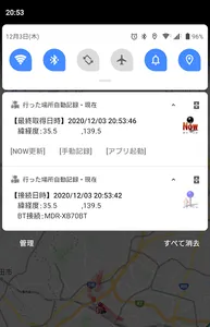
Automatic recording of where you went
The place you went (action record) was recorded "automatically", and where were you at that time that day? Where did you go? Can be confirmed "later" on the map.
* Recorded location information (latitude and longitude) is saved only in your smartphone . We do not do anything to communicate, forward, or send to the outside without permission. Please use with confidence.
You can use it in the following cases!
・ After traveling or going out, where did you go and how did you come back?
・ Where did you go through and where did you stop when you lost something?
・ I want to tell my friends where I am now at events (a wide range of fireworks festivals, outdoor live venues, etc.)
・ Where did the Bluetooth with the car etc. break?
(Place where the car was parked in a large parking lot, place where the earphone was dropped, etc.)
・ For example, when you want to check the behavior history of the past 2 weeks or 1 month
・ I want to know the location I went to and the Wifi spot that was automatically connected on the route I took.
・ I went around a lot for work all day, but when, where, and how much did I move?
・ Where were you around 00:00 on the 0th of October? ?? ??
When did you go to the □□ store? ?? ??
・ I don't remember being drunk, but when, where, and how did you come back?
・ How long does it take to move from point A to point B?
・ What is the average speed while recording at regular intervals?
・ I've climbed a mountain, but where and how did you climb it?
・ Put it in an old smartphone that you no longer need and use it for location recording
・ In addition, there are various ways to use it depending on your ideas! ??
Please feel free to try it once.
・ This application is resident and can be started immediately from the status bar.
* Resident may be canceled due to model settings, etc. In that case, please start it manually. (Mainly in the middle of the night)
・ Periodically acquire location information and save it in your smartphone.
The position acquisition and save interval can be changed within the app. The default setting is once every 3 minutes.
・ Acquires location information when connecting via Bluetooth disconnection and saves it in the smartphone.
At the same time, the Bluetooth device name is also acquired and saved.
(You can see when and where which Bluetooth device was connected / disconnected)
・ When the Wifi connection is disconnected, the location information is acquired and saved in the smartphone.
When connecting, the Wifi spot name is also acquired and saved.
(You can see when, where, and what name you connected to Wifi.
Wifi may be connected in an unexpected place)
・ Combine close coordinate information.
Since the location information (latitude and longitude) changes slightly even if you are in the same place, if it is within a certain range, it will be regarded as the same point and the information will be recorded and saved.
The initial setting value is up to the 3rd digit after the decimal point, and the 4th digit is considered to be the same point within the range of cut = about 100 meters.
(The setting value can be changed. Please set according to your scene)
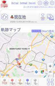
・ A pin will appear at the location of the location information saved on the map in the app.
You can see at a glance where and how you acted.
・ You can copy the location information to the clipboard and send it by e-mail.
You can tell a third party your current location or where you went in the past.
・ You can export location information (TSV format).
You can teach a third party your own action record to a third party and keep the record.
・ Location information can be protected and deleted.
If the number of saved items is exceeded, the oldest information will be deleted, but it can be excluded from the deletion target by protecting it.
Also, it can be deleted manually, and you can keep a record of actions (memories) of the place you went by using it together with the protection settings.
・ You can protect your action history from third parties.
You can set a password and lock the reference of the action history.
Preparation is required as a prerequisite. (it's simple)
Please make the following preparations before using.
・ Keep the location information of your smartphone "ON" at all times
0. Launch the app
Tap the icon to start the app.
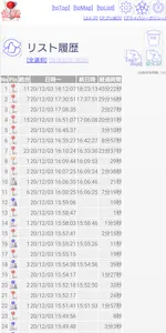
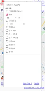
1. View list history
Tap "Filter" at the bottom of the main screen.
The list filter screen will start, so select the period you want to check and tap [Apply].
The saved location information is displayed in a list, and a pin is placed on the coordinate value on the map.
* The larger the number of targets, the longer it will take to generate the list.
Please limit the number of targets by filtering under appropriate conditions.
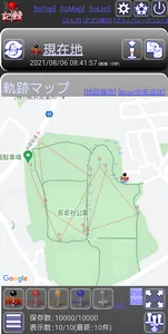
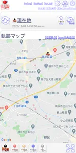
2. Map operation
Tap [Map operation] at the top of the map.
Map operations such as moving and enlarging / reducing the map are possible.
* When operating the map, [Now center follow] and [Now / list → map synchronization] are forcibly turned off.
3. Follow the current position
Tap [Now center follow] at the top of the map.
Follow with the current value "Now pin" in the center of the map.
When moving by car or train, you can check where and how you are moving now.
Four. Update lists and maps in real time
Tap "Now / List → Map Sync" at the bottom of the map.
The information that is regularly saved is displayed in a list in real time, and pins are placed on the map.
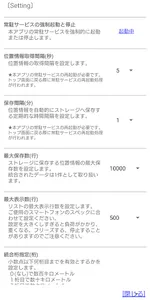
5. Change various settings
Tap the gear icon at the top of the main screen to open the setting screen.
Please set according to your environment such as regular storage time, number of merged digits, display / non-display of latitude / longitude, etc.
Item:
・ Starting and stopping the resident service
Forcibly start / stop the resident service.
・ Location information acquisition interval (seconds)
Set the location information acquisition interval when the app is launched.
The initial setting is 10 seconds.
・ Active marker [New]
Set the number of displays and the interval when displaying the trajectory of the current location.
・ Storage interval (minutes)
Set the interval for saving location information on a regular basis.
The initial setting is 3 minutes.
・ Maximum number of saved items (row)
Set the maximum number of saves to be saved in the storage.
The initial setting is 10000 lines.
・ Maximum number of displays (lines)
Set the maximum number of lists to be displayed.
The initial setting is 500 lines.
・ Integrated digit designation (digit)
Set the number of digits after the decimal point of latitude and longitude to be valid.
The initial setting is 3 digits.
・ Initial display number of application startup (line) [New]
Set the initial display number when the application is started.
The initial setting is not specified (previous filter).
・ Warning display when generating a list [New]
Set warnings when displaying multiple data.
The initial setting is 500 lines.
・ Display of calculation of latitude / longitude, brightness, barometric pressure (hPa), information (memo), and travel distance
The initial setting is OFF.
・ Calculation and display of elapsed time
The initial setting is ON.
・ Calculation and display of speed
The initial setting is OFF.
・ Bluetooth connection / disconnection notification, Wi-Fi connection / disconnection notification
You can set the notification method.
Notification bar, sound, and vibration can be set individually.
・ Notification display time [New]
Set the display time for Bluetooth and Wi-Fi connection / disconnection notifications.
★ Valid on Android 8.0 and above
・ Trajectory line [New]
Set the color and thickness of the locus line that connects the pins with a line.
・ Do not optimize the battery
★ Valid on Android 6.0 and above
・ Action history display lock
The initial setting is OFF.
This app acquires location information from GPS, mobile phone base stations, and Wifi.
Depending on the aircraft and environment (situation), position information that is far from the actual coordinate values may be acquired.
Red pin: Position for regular automatic acquisition
Blue pin: The position where both when Bluetooth is connected to something and when it is disconnected, etc.
White pin: Wi-Fi disconnected, position when connected
Skin color pin: The position where the Now position was manually recorded and saved.
* This application is free (advertisements will be displayed).
Developed in @Japan & ALL Japan.
-Acknowledgments-
Everyone who cooperated
Thank you for your support while you are busy.
Thank you for taking this opportunity.
-Contributing to society through work-
PDS PIS Innovation Lab
Automatic recording of where you went
The place you went (action record) was recorded "automatically", and where were you at that time that day? Where did you go? Can be confirmed "later" on the map.
* Recorded location information (latitude and longitude) is saved only in your smartphone . We do not do anything to communicate, forward, or send to the outside without permission. Please use with confidence.
You can use it in the following cases!
・ After traveling or going out, where did you go and how did you come back?
・ Where did you go through and where did you stop when you lost something?
・ I want to tell my friends where I am now at events (a wide range of fireworks festivals, outdoor live venues, etc.)
・ Where did the Bluetooth with the car etc. break?
(Place where the car was parked in a large parking lot, place where the earphone was dropped, etc.)
・ For example, when you want to check the behavior history of the past 2 weeks or 1 month
・ I want to know the location I went to and the Wifi spot that was automatically connected on the route I took.
・ I went around a lot for work all day, but when, where, and how much did I move?
・ Where were you around 00:00 on the 0th of October? ?? ??
When did you go to the □□ store? ?? ??
・ I don't remember being drunk, but when, where, and how did you come back?
・ How long does it take to move from point A to point B?
・ What is the average speed while recording at regular intervals?
・ I've climbed a mountain, but where and how did you climb it?
・ Put it in an old smartphone that you no longer need and use it for location recording
・ In addition, there are various ways to use it depending on your ideas! ??
Please feel free to try it once.
・ This application is resident and can be started immediately from the status bar.
* Resident may be canceled due to model settings, etc. In that case, please start it manually. (Mainly in the middle of the night)
・ Periodically acquire location information and save it in your smartphone.
The position acquisition and save interval can be changed within the app. The default setting is once every 3 minutes.
・ Acquires location information when connecting via Bluetooth disconnection and saves it in the smartphone.
At the same time, the Bluetooth device name is also acquired and saved.
(You can see when and where which Bluetooth device was connected / disconnected)
・ When the Wifi connection is disconnected, the location information is acquired and saved in the smartphone.
When connecting, the Wifi spot name is also acquired and saved.
(You can see when, where, and what name you connected to Wifi.
Wifi may be connected in an unexpected place)
・ Combine close coordinate information.
Since the location information (latitude and longitude) changes slightly even if you are in the same place, if it is within a certain range, it will be regarded as the same point and the information will be recorded and saved.
The initial setting value is up to the 3rd digit after the decimal point, and the 4th digit is considered to be the same point within the range of cut = about 100 meters.
(The setting value can be changed. Please set according to your scene)
・ A pin will appear at the location of the location information saved on the map in the app.
You can see at a glance where and how you acted.
・ You can copy the location information to the clipboard and send it by e-mail.
You can tell a third party your current location or where you went in the past.
・ You can export location information (TSV format).
You can teach a third party your own action record to a third party and keep the record.
・ Location information can be protected and deleted.
If the number of saved items is exceeded, the oldest information will be deleted, but it can be excluded from the deletion target by protecting it.
Also, it can be deleted manually, and you can keep a record of actions (memories) of the place you went by using it together with the protection settings.
・ You can protect your action history from third parties.
You can set a password and lock the reference of the action history.
Preparation is required as a prerequisite. (it's simple)
Please make the following preparations before using.
・ Keep the location information of your smartphone "ON" at all times
0. Launch the app
Tap the icon to start the app.
1. View list history
Tap "Filter" at the bottom of the main screen.
The list filter screen will start, so select the period you want to check and tap [Apply].
The saved location information is displayed in a list, and a pin is placed on the coordinate value on the map.
* The larger the number of targets, the longer it will take to generate the list.
Please limit the number of targets by filtering under appropriate conditions.
2. Map operation
Tap [Map operation] at the top of the map.
Map operations such as moving and enlarging / reducing the map are possible.
* When operating the map, [Now center follow] and [Now / list → map synchronization] are forcibly turned off.
3. Follow the current position
Tap [Now center follow] at the top of the map.
Follow with the current value "Now pin" in the center of the map.
When moving by car or train, you can check where and how you are moving now.
Four. Update lists and maps in real time
Tap "Now / List → Map Sync" at the bottom of the map.
The information that is regularly saved is displayed in a list in real time, and pins are placed on the map.
5. Change various settings
Tap the gear icon at the top of the main screen to open the setting screen.
Please set according to your environment such as regular storage time, number of merged digits, display / non-display of latitude / longitude, etc.
Item:
・ Starting and stopping the resident service
Forcibly start / stop the resident service.
・ Location information acquisition interval (seconds)
Set the location information acquisition interval when the app is launched.
The initial setting is 10 seconds.
・ Active marker [New]
Set the number of displays and the interval when displaying the trajectory of the current location.
・ Storage interval (minutes)
Set the interval for saving location information on a regular basis.
The initial setting is 3 minutes.
・ Maximum number of saved items (row)
Set the maximum number of saves to be saved in the storage.
The initial setting is 10000 lines.
・ Maximum number of displays (lines)
Set the maximum number of lists to be displayed.
The initial setting is 500 lines.
・ Integrated digit designation (digit)
Set the number of digits after the decimal point of latitude and longitude to be valid.
The initial setting is 3 digits.
・ Initial display number of application startup (line) [New]
Set the initial display number when the application is started.
The initial setting is not specified (previous filter).
・ Warning display when generating a list [New]
Set warnings when displaying multiple data.
The initial setting is 500 lines.
・ Display of calculation of latitude / longitude, brightness, barometric pressure (hPa), information (memo), and travel distance
The initial setting is OFF.
・ Calculation and display of elapsed time
The initial setting is ON.
・ Calculation and display of speed
The initial setting is OFF.
・ Bluetooth connection / disconnection notification, Wi-Fi connection / disconnection notification
You can set the notification method.
Notification bar, sound, and vibration can be set individually.
・ Notification display time [New]
Set the display time for Bluetooth and Wi-Fi connection / disconnection notifications.
★ Valid on Android 8.0 and above
・ Trajectory line [New]
Set the color and thickness of the locus line that connects the pins with a line.
・ Do not optimize the battery
★ Valid on Android 6.0 and above
・ Action history display lock
The initial setting is OFF.
This app acquires location information from GPS, mobile phone base stations, and Wifi.
Depending on the aircraft and environment (situation), position information that is far from the actual coordinate values may be acquired.
Red pin: Position for regular automatic acquisition
Blue pin: The position where both when Bluetooth is connected to something and when it is disconnected, etc.
White pin: Wi-Fi disconnected, position when connected
Skin color pin: The position where the Now position was manually recorded and saved.
* This application is free (advertisements will be displayed).
Developed in @Japan & ALL Japan.
-Acknowledgments-
Everyone who cooperated
Thank you for your support while you are busy.
Thank you for taking this opportunity.
-Contributing to society through work-
PDS PIS Innovation Lab
Show More