AppRecs review analysis
AppRecs rating 3.7. Trustworthiness 83 out of 100. Review manipulation risk 19 out of 100. Based on a review sample analyzed.
★★★☆☆
3.7
AppRecs Rating
Ratings breakdown
5 star
44%
4 star
17%
3 star
17%
2 star
6%
1 star
17%
What to know
✓
Low review manipulation risk
19% review manipulation risk
✓
Credible reviews
83% trustworthiness score from analyzed reviews
✓
Good user ratings
61% positive sampled reviews
About Mergin Maps: QGIS in pocket
Enter your data once, with ease, in the field. Mergin Maps aims to remove the pain of transcribing paper field notes, manually georeferencing photos and transcribing GPS coordinates.
The data you capture in the field survey is shown on a map and can be exported to a wide variety of formats including CSV, Microsoft Excel, ESRI Shapefile, Mapinfo, GeoPackage, PostGIS, AutoCAD DXF, KML and many more.
Mergin Maps Input is an extension of the free and open source GIS software QGIS. It allows you to open, interrogate and edit your QGIS projects on your mobile. Map layers look the same as in QGIS desktop and you can sync your data back and forward with QGIS desktop using the Mergin Maps QGIS plugin.
Mergin Maps supports offline field data capture and can be configured to use either offline or web-based background maps and contextual layers.
Perks of the Mergin Maps sync system:
- No need for cables to get your data on/off your device
- Share projects with others for collaborative working
- Safely work together on the same datasets, even offline
- Updates from different surveyors are intelligently merged
- Push data back from the field in real time
- Version history and cloud-based backup
- Fine-grained access control
- Sync with your PostGIS datasets
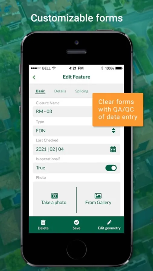
Supported field types for forms are:
- Text (single or multi-line)
- Numeric (plain, with +/- buttons or with slider)
- Date / time (with calendar picker)
- Photo
- Checkbox (yes/no values)
- Drop-down with predefined values
- Drop-down with values from another table
Forms can even be configured to perform data validation using custom rules.
Works with device internal GPS receiver and third-party Bluetooth GPS receivers.
Mergin Maps: QGIS in pocket Screenshots


Tap to Rate:
Reviews for Mergin Maps: QGIS in pocket
Wiretalker
Tried 2nd worst app
Open maps is the only app worse than this one. Cannot use this without downloading maps to your phone to explore. I don’t trust that. I have worked with maps for many many years. Another person mentioned QField if they had a better menu I would not look for any other app. At this point HuntStand beats many so called map apps. This one seems useless unless you make another account just to try an apps potential. Other people say it needs work and I could not get far enough past bad ideas to try any functions. You have a menu so that’s the only reason this is not the worst.
mmurky
Excellent for data collection & helpful support team
I have been using Mergin Maps for an academic research project and it has been a blessing. It’s made it so easy to collect field data from my phone and sync with my QGIS file at home. Customer support has also been very prompt and helpful when I had issues with my payment plan. Recommend!