White Risk
WSL-Institut für Schnee- und Lawinenforschung SLF
5.0 ★
4 ratings
Free
AppRecs review analysis
AppRecs rating 4.5. Trustworthiness 52 out of 100. Review manipulation risk 26 out of 100. Based on a review sample analyzed.
★★★★☆
4.5
AppRecs Rating
Ratings breakdown
5 star
100%
4 star
0%
3 star
0%
2 star
0%
1 star
0%
What to know
✓
High user satisfaction
100% of sampled ratings are 5 stars
About White Risk
White Risk is the Swiss platform for avalanche prevention and was awarded Best Swiss App in 2025. It is designed and developed at the WSL Institute for Snow and Avalanche Research SLF and is aimed at everyone who travels in winter mountain terrain outside secured ski slopes.
In addition to the avalanche bulletin and current snow and measurement data, White Risk includes a trip planning tool specialized for ski touring, snowshoe routes and freeride. Draw your own routes, analyze the terrain using avalanche terrain maps and automatic cruxes, and plan alternatives. Through e learning, White Risk conveys avalanche knowledge and deepens it with interactive lessons and exercises.
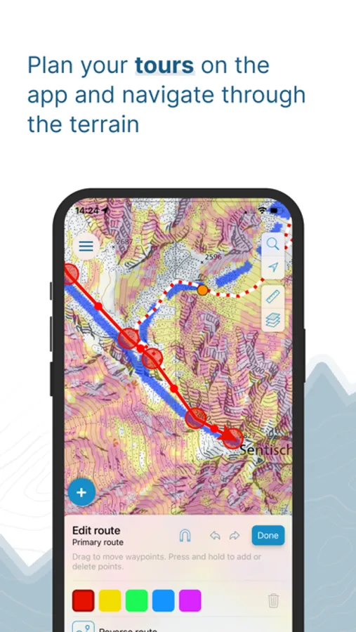
Tour planning: Draw routes along paths or ski routes or freely across the terrain and store all relevant information about your tour in one place.
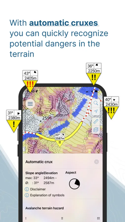
Automatic cruxes: White Risk analyzes your route, automatically marks potentially critical cruxes and complements them with relevant avalanche and terrain information.
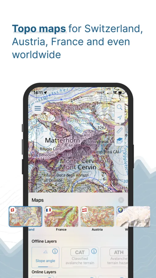
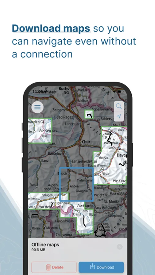
Use maps offline: Download map material with topographic maps as well as layers such as slope angle and avalanche terrain for planning and navigation on the go.
Synchronization across all platforms: All planned tours are stored in the personal account and can be accessed and edited at any time via app and web.
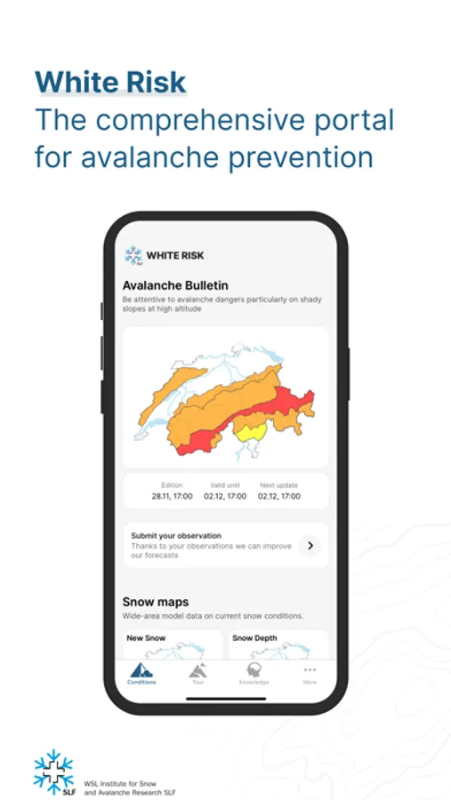
Avalanche bulletin: The avalanche bulletin provides information on the current avalanche situation. It offers a regional forecast of avalanche danger and is an important basis for trip planning.
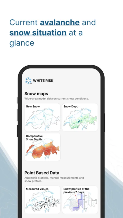
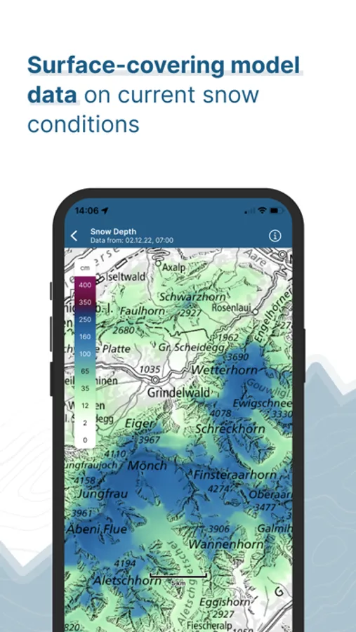
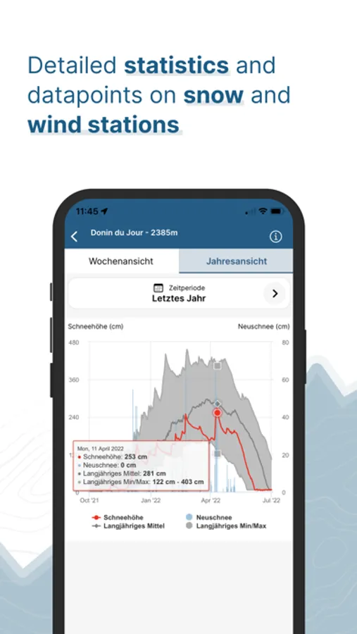
Snow maps, measurements and observations: Display of current and forecast new snow amounts as well as snow depths for Switzerland, complemented by measurements from stations and current observations such as avalanches and snow profiles.
E learning: White Risk conveys avalanche knowledge using graphics, videos and animations and deepens it in interactive lessons with exercises and knowledge tests.
In addition to the avalanche bulletin and current snow and measurement data, White Risk includes a trip planning tool specialized for ski touring, snowshoe routes and freeride. Draw your own routes, analyze the terrain using avalanche terrain maps and automatic cruxes, and plan alternatives. Through e learning, White Risk conveys avalanche knowledge and deepens it with interactive lessons and exercises.
Tour planning: Draw routes along paths or ski routes or freely across the terrain and store all relevant information about your tour in one place.
Automatic cruxes: White Risk analyzes your route, automatically marks potentially critical cruxes and complements them with relevant avalanche and terrain information.
Use maps offline: Download map material with topographic maps as well as layers such as slope angle and avalanche terrain for planning and navigation on the go.
Synchronization across all platforms: All planned tours are stored in the personal account and can be accessed and edited at any time via app and web.
Avalanche bulletin: The avalanche bulletin provides information on the current avalanche situation. It offers a regional forecast of avalanche danger and is an important basis for trip planning.
Snow maps, measurements and observations: Display of current and forecast new snow amounts as well as snow depths for Switzerland, complemented by measurements from stations and current observations such as avalanches and snow profiles.
E learning: White Risk conveys avalanche knowledge using graphics, videos and animations and deepens it in interactive lessons with exercises and knowledge tests.
White Risk Screenshots

Tap to Rate:
Reviews for White Risk
mikech123
Awesome
Wonderful app for ski touring. A must have in Switzerland and getting better abroad. Tiny bug — on iPhone the app doesn’t use the system setting for units. Mine is set for metric but I still see miles (probably because my region is set to USA?)
erskingardner
Fantastic!
Great repurpose of the already great content from the Swiss avalanche service site.