In this mapping and measurement app, you can measure distances, perimeters, and areas using satellite imagery and various map types. Includes autosave, undo and redo functions, and support for multiple map sources.
AppRecs review analysis
AppRecs rating 4.6. Trustworthiness 65 out of 100. Review manipulation risk 32 out of 100. Based on a review sample analyzed.
★★★★☆
4.6
AppRecs Rating
Ratings breakdown
5 star
80%
4 star
11%
3 star
3%
2 star
2%
1 star
4%
What to know
✓
High user satisfaction
80% of sampled ratings are 5 stars
✓
Authentic reviews
Natural distribution, no red flags
About Measure Map Pro
Calculate surface areas, buildings, plots, floors, forest areas or dimensions for fencing, sports tours, trips or anything you need for field work without having to go to the spot to take measurements. Only one finger to calculate with astonishing accuracy all these measurements over satellite images.
That’s what Measure Map Pro is for, to put a powerful, portable measuring tool right in the palm of your hand. Your iPhone, iPod touch or iPad can now provide you with totally precise measurements of any distance, from as small as one tenth of a meter to as big as thousands of kilometers or miles, even taking the curvature of the earth’s surface into account when measuring. It does all that, fast and effortlessly.
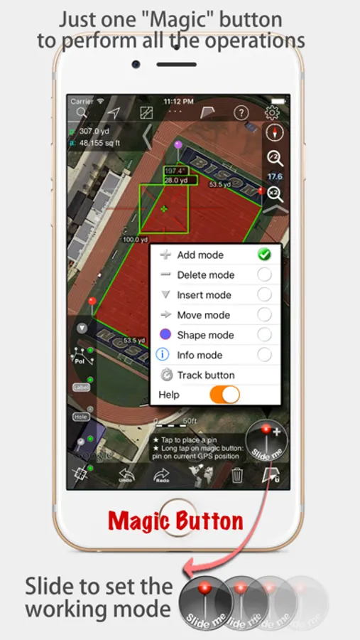
Just one "magic" button for all the operations to easily place points without loosing it's professional accuracy.
Some impressive features you get in Measure Map Pro (some of them via in-app purchase):
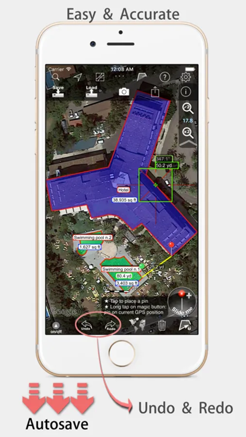
* Autosave
* Attractive, smooth, easy navigation and use
* For iPhone and iPad
* Apple or G00GLE Maps with extra zoom level.
* Displays Maps View: Map, Satellite, Hybrid and Terrain.
* Undo and redo operations as needed
* AirPrint and iCloud support
* More maps with extra zoom level through in-app purchase: Bing, Here, and ArcGIS. And Open Street, Open Cycle, World Street and more in the future
* Operations: Add, delete intermediate pins, insert between pins, move pins, get info.
* Circles and rectangles
* Multiple areas and routes on screen
* Display of altitude above sea level, azimuth and angle
* Calculates azimuth or bearing
* Search for current location, text (villages, places of interest, etc.)
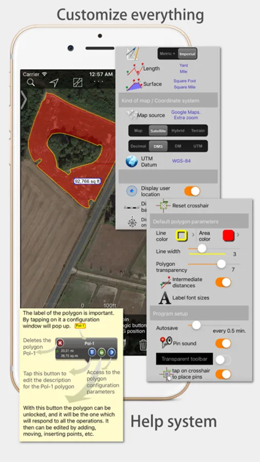
* Length units: meters, kilometers, feet, yards, miles, nautical miles, ken, ri, bù, lǐ
* Surface units: square meters and kilometers, ares, hectares, square foot, square yards, square miles, acres, fanegas (Valencian, Castilian or Colombian), tsubo, bu, so, lí, mǔ
* Intermediate distances between pins can be displayed
* Attach pictures to points
* Ability to select color and thickness of the perimeter line.
* Ability to select the color and transparency of the selected area.
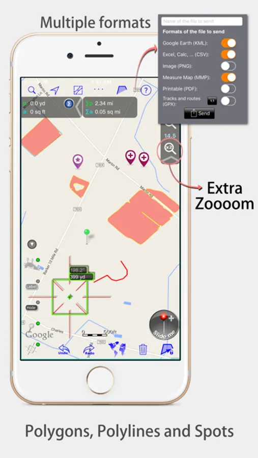
* Working format: Measure Map, KMZ, KML (G00GLE Earth), CSV (Excel), Autocad (DXF), Shape (SHP), GPX, Image (PNG) and PDF
* Export and import of surfaces and routes via e-mail, iTunes, AirDrop and Dropbox.
* Save to photo album
* Download surfaces and routes from the Internet.
* Calculates multiple areas and routes simultaneously
* Ability to create inner polygons as "holes".
* Drawing of shapes: circle and rectangle.
* More maps with extra zoom level through in-app purchase
* Calculates azimuth or bearing
* Attach pictures to points
* Displays altitude above sea level, azimuth and angle.
* Imports KML, KMZ and GPX format files besides exporting them.
* Track mode: drops pins on current GPS position at regular intervals.
(Continued use of GPS running in the background can dramatically decrease battery life)
* Coordinate system DM
* Apple Pencil drawing mode (with iPad Pro)
* Image layers
If precise measurements are important to you, this is the app you need. You won’t find one that is better, more accurate and easier to use.
Measure Map Pro Screenshots

Tap to Rate:
Reviews for Measure Map Pro
Jsnipes10
Long time User
I am in the asphalt business, and have been using MeasureMap for nearly 10 years at this point. At first, I didn’t trust the measurements and would go verify everything by hand. The margin of error was negligible …even less so now with all the experience i have drawing site maps up on MeasureMap. The multiple sources of satellite images reduce the amount of times i find myself without a good satellite image, with some being taken in the winter which helps with parking lots surrounded by trees. Anyone talking bad in their review clearly doesn’t know what they are talking about. The ONLY gripe i have about this app is the lack of the ability to group my drawn shapes into layers, so i can have the subtotals of different types of work totaled for me instead of having to manually go thru and separate anything i want in a separate group. Other than that this app is incredibly accurate and useful. I don’t write reviews, but i was checking the app store to see if there was an update for the app and i saw the reviews and thought “these guys have no idea what they are talking about”
Toddep23
draw function?
Why isn’t there a function where you can draw the area with your finger? This would me much better for measuring areas that are irregular