In this app, you can analyze propagation conditions, view graphs, and access various forecasting tools. Includes propagation maps, grayline overlays, ionosonde data, and aurora prediction maps.
AppRecs review analysis
AppRecs rating 4.3. Trustworthiness 80 out of 100. Review manipulation risk 22 out of 100. Based on a review sample analyzed.
★★★★☆
4.3
AppRecs Rating
Ratings breakdown
5 star
64%
4 star
22%
3 star
4%
2 star
4%
1 star
4%
What to know
✓
Low review manipulation risk
22% review manipulation risk
✓
Credible reviews
80% trustworthiness score from analyzed reviews
✓
High user satisfaction
87% of sampled ratings are 4+ stars (4.4★ average)
About DX Toolbox
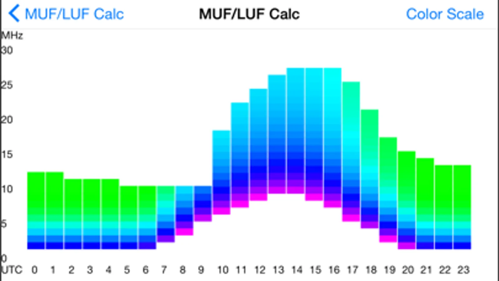
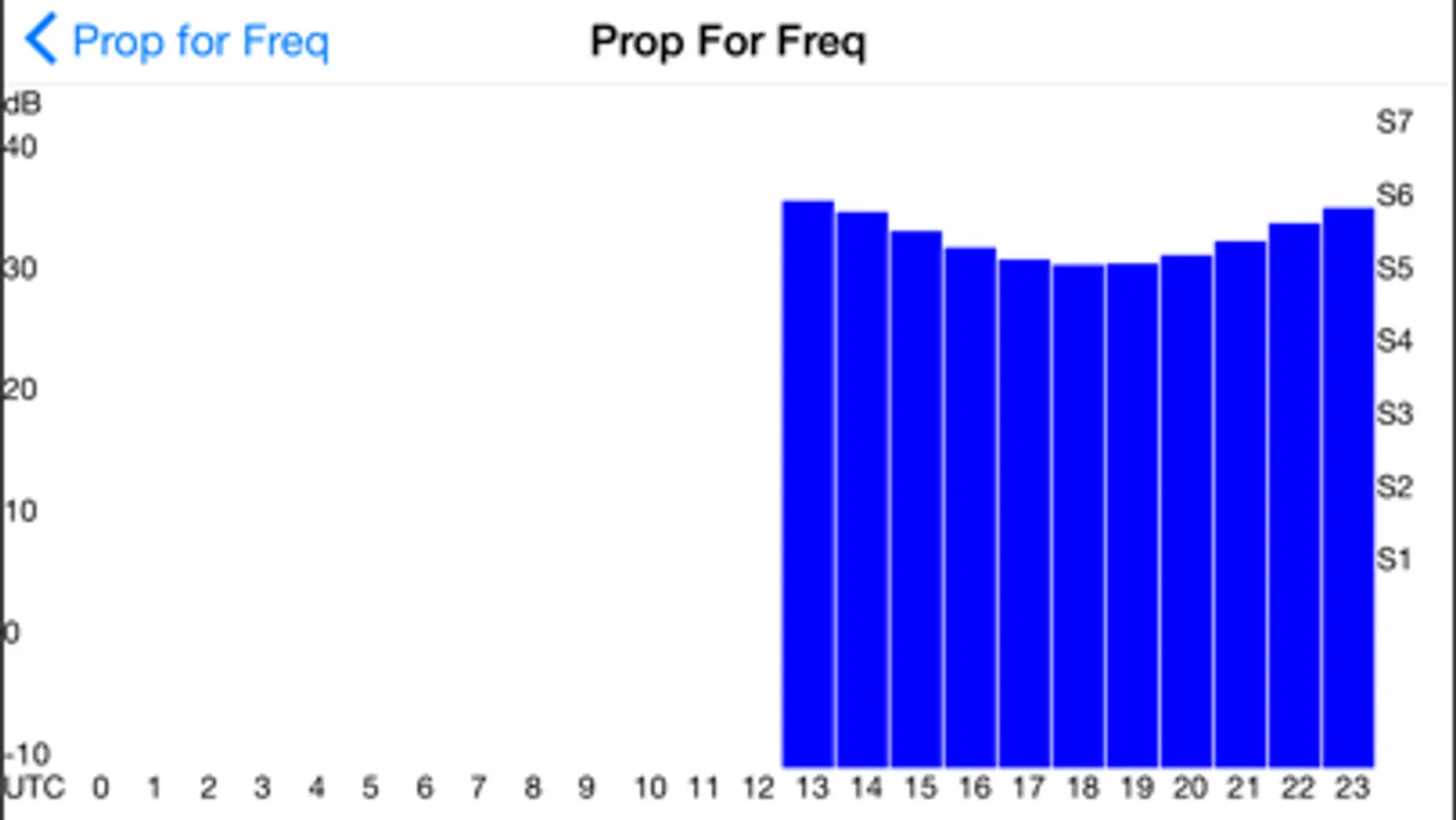
Radio propagation conditions can also be estimated between any two points on the Earth. Graphs of these conditions can be generated for a given frequency or time, and MUF/LUF graphs can also be displayed.
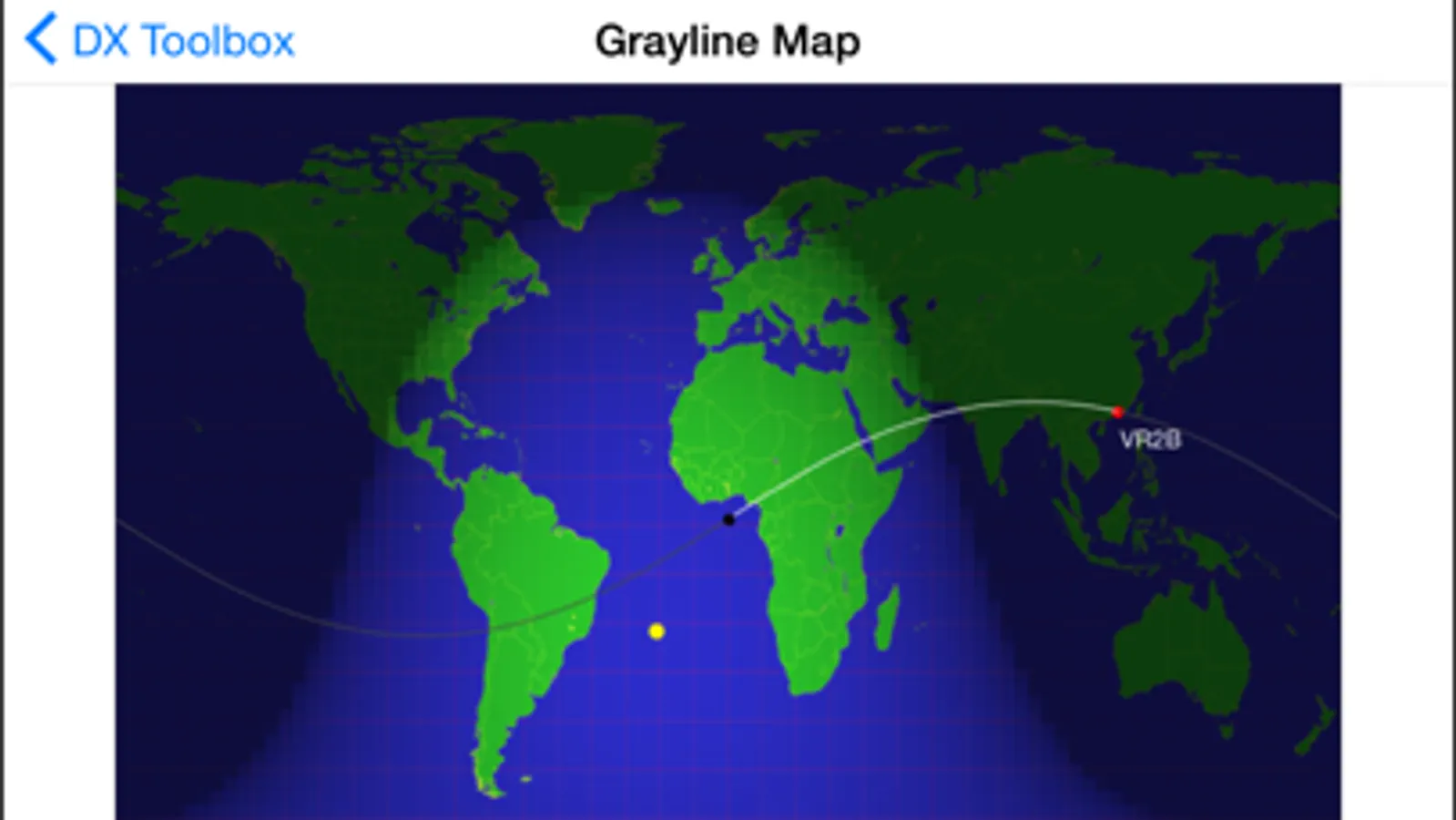
A grayline map of the world is also available. Radio propagation between locations within the grayline region of the world is often greatly enhanced. DX Toolbox's grayline map makes it easy for you to determine where those locations are. Grayline propagation has been used by expert radio operators and DXers for years to catch elusive stations. A plot the great circle (both short and long) path between your location and another station is also displayed, as well as the beam heading and distance. The location of the currently transmitting NCDXF/IARU beacon can be displayed on the map as well.
The propagation map displays the areas of the world where your signal can be heard (or a signal can be heard from), based on the frequency, transmitter power, and current solar flux, date, and time.
Maps showing ionosonde plots of foF2, foEs, and hmF2 data from various locations around the world are available. The MUF and skip zone can be calculated based on foF2 and hmF2 values.
Aurora prediction maps for the northern and southern hemisphere are available.
DX Toolbox displays the following important solar and geomagnetic readings:
Solar Flux
A-Index
K-Index
Sun Spot Number
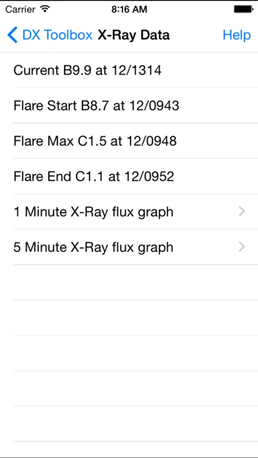
X-Ray Flux levels
X-Ray flares
Solar Wind
Earth's Magnetic Field
Proton and Electron Flux levels
Radio Blackout conditions
Geomagnetic Storm conditions
Solar Radiation Storm conditions
Graphs of x-ray flux readings from the GOES satellites may also be displayed.
The following radio propagation reports and forecasts are available:
WWV Geophysical Alert
27 Day Space Outlook
45 Day AP Forecast
Geomagnetic Data
Daily Geomagnetic Data
Daily Particle Data
Daily Solar Data
GEOALERT
Daily Magnetometer Analysis Reports
Hourly Magnetometer Analysis Reports
Predicted Sunspot Numbers and Radio Flux
Report of Solar-Geophysical Activity
Solar and Geophysical Activity Summary
Solar Region Summary
Weekly Highlights and Forecasts
Current Space Weather Indices
Space Weather Event Reports
Daily Space Weather Indices
Summary of Space Weather Observations
3-day Space Weather Predictions
SEC Space Weather Alerts
In addition, 21 maps of current D Layer Absorption levels are available for display.
Full documentation on how to use the app is available here: http://www.blackcatsystems.com/iphone/dx_toolbox_faq.html
Get your copy of DX Toolbox now, and you’ll always be up to date on current radio propagation conditions.
DX Toolbox Screenshots

Tap to Rate:
Reviews for DX Toolbox
Lookingwolf
Handy DX APP
Using a new IPhone 16… The app has a lot of links to solar data. Half of the info links don’t download. If the data does download, it takes a long time. ( cell network connection) The graphs and pictures are small and hard to see on my IPhone. The link labels could be little more informative as to the data origin. Some of the downloaded data pages display about half of the document and will not scroll down to see the remainder of the document. Some graphs’ X and Y axis are not labeled. Some of the data, of course is useful. But, you have to hunt and peck through the copious menu items to determine which menu item will download or provide the common ham operator useful displayed data. Overall, I use it occasionally. However, it’s just as convenient to go to the NASA’s Space Weather website.
Jhkayakr
Doesn’t work anymore
I can’t get most of it to work anymore. None of the maps work. Only the home page. What gives?