AppRecs review analysis
AppRecs rating 4.6. Trustworthiness 77 out of 100. Review manipulation risk 25 out of 100. Based on a review sample analyzed.
★★★★☆
4.6
AppRecs Rating
Ratings breakdown
5 star
68%
4 star
16%
3 star
0%
2 star
0%
1 star
16%
What to know
✓
Low review manipulation risk
25% review manipulation risk
✓
Credible reviews
77% trustworthiness score from analyzed reviews
✓
High user satisfaction
84% of sampled ratings are 4+ stars (4.2★ average)
About Marine Navigation-USA Lake Map
* Hardware/GPU accelarated vector charts (text stays upright on rotation).
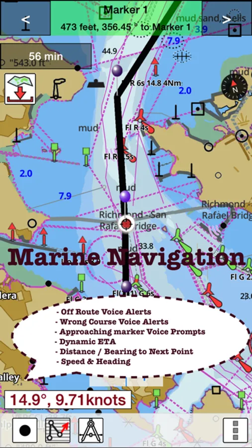
* Voice Prompts for marine navigation (requires GPS )
* 1ft / 3ft depth contour maps for anglers for selected lake maps.
* Supports GPX/KML for boating route editing/import.
* Tide & Currents prediction.
* Seamless chart quilting of marine charts
* Enter way points
* Record tracks, Autofollow with realtime track overlay
* Voice Prompts for marine navigation (requires GPS )
-prompts when approaching a boating route marker
-Continous distance and ETA updates
-Alerts when sailing/boating off route
-Alerts when boating in wrong direction
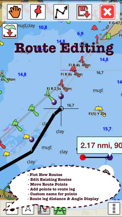
*Route Editing/Creation
-Create routes from scratch
-Edit existing GPX/KML routes.
-Add custom description to any route point.
-Drop markers along route.
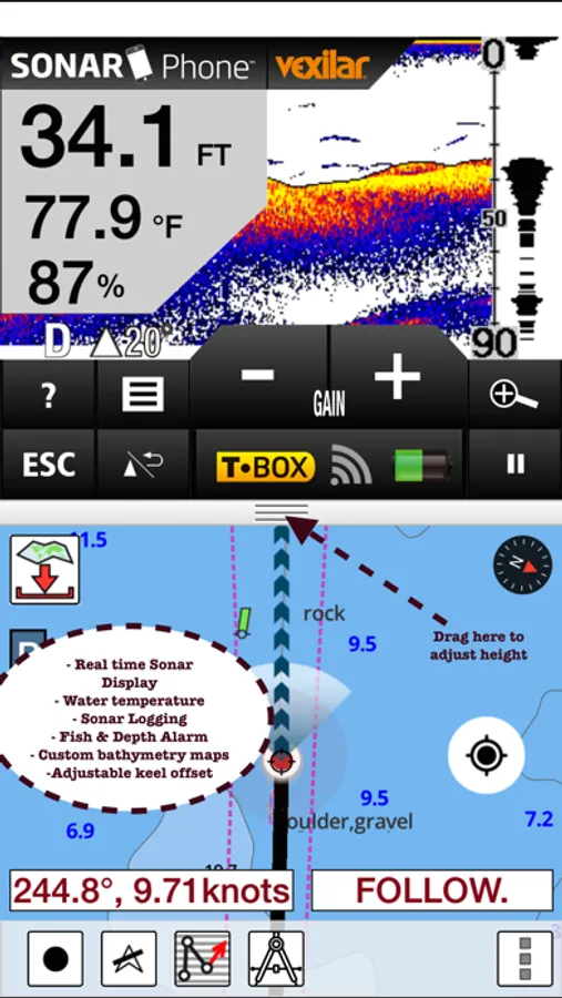
* Offline NOAA marine, lake & river charts
-Visually download using grid
-Textual search
* Tide & Currents
- High / Low tides.
- Tidal Currents.
- Active currents stations.
*Seamless chart quilting of marine charts
*Distance Bearing tool
*Create custom way points
- Using GPS
-Select point on map
-Manually enter latitude & longitude coordinates
*Pan/Zoom/My Location
* Record Marine GPS tracks
* View tracks overlay
* Live track animation
* Track analytics/stats
* Export GPX trcks.
-Export to SDCard
-Share GPX tracks with friends.
* Auto Follow Mode (Course up)
-Continuously updates boat's location on chart
- Adjustable update frequency
Sample Nautical Charts (please visit http://gpsnauticalcharts.com/main/folio-catalog-nautical-charts-app for complete list)
SUGARLOAF KEY-KEY WEST
PORT RICHEY TAMPA BAY - CLEARWATER HBR
EAST BAY-WEST BAY FLORIDA
ST JOSEPH, ST ANDREW BAYS
INTRACOASTAL WATERWAY MATECUMBE-GRASSY KEY
CHESAPEAKE BAY CAPE CHARLES-NORFOLK HARBOR
ANCLOTE KEYS-CRYSTAL RIVER
ST JOSEPH SOUND
MIAMI HARBOR
Minnesota lakes - Kabetogama, Minnetonka, Waconia,Leech,Mille Lacs
Lake Keowee,Jocassee,Hartwell,Greenwood,Lake Murray
Mark Twain,Ozarks,Table Rock
Lake St. Clair
Lake Kentucky
KEY WEST-THE MISSISSIPPI RIVER
SAN PEDRO CHANNEL
LAKE MICHIGAN STONY LAKE-POINT BETSIE
APALACHICOLA BAY-CAPE SAN BLAS
EAST CAPE-MORMON KEY
CAPE HENLOPEN-INDIAN RIVER INLET
CHESAPEAKE BAY CAPE HENRY-THIMBLE SHOAL LIGHT
DULUTH-SUPERIOR HARBOR
MONHEGAN ISLAND-CAPE ELIZABETH
LAKE ONTARIO - CLAYTON-FALSE DUCKS ISL
Lake Winnipesaukee
SAN FRANCISCO ENTRANCE
MIAMI-MARATHON, FLORIDA BAY
CAPE MAY-FENWICK ISLAND
MISSISSIPPI RIVER-GALVESTON
CAPE CANAVERAL-KEY WEST
DELAWARE RIVER WILMINGTON-PHILADELPHIA
FLORIDA KEYS SOMBRERO KEY-SAND KEY
SAN PABLO BAY
RAINY LAKE BIG ISLAND MINN-OAKPOINT ISL ONT
INTRACOASTAL WATERWAY - BISCAYNE BAY
EVERGLADES NTL PARK - SHARK RVR-LOSTMANS RVR
MIAMI-MARATHON & FLORIDA BAY
BLACKBURN BAY
LAKE HURON
LAKE TAHOE
STRAITS OF MACKINAC
NORFOLK HARBOR & ELIZABETH RIVER
SAN DIEGO-SANTA ROSA ISLAND
DELAWARE BAY
CHOPTANK RIVER CAMBRIDGE-GREENSBORO
FORT LAUDERDALE PORT EVERGLADES
ST SIMONS SOUND-TOLOMATO RIVER
CHESAPEAKE DELAWARE CANAL
CAPE MENDOCINO
STRAIT OF JUAN DE FUCA ENTRANCE
PORT RICHEY CLEARWATER HBR
PAMPANO BEACH-HALLADALE FLORIDA
LAKE ERIE
LAKE MICHIGAN INCLUDING GREEN BAY
MAIMI-MARATHON and FLORIDA BAY
SANTA CATALINA ISLAND
APALACHICOLA BAY-LAKE WIMICO
Battery Disclaimer:
"Continued use of GPS running in the background can dramatically decrease battery life."
Marine Navigation-USA Lake Map Screenshots


Tap to Rate:
Reviews for Marine Navigation-USA Lake Map
Xeroform_
used to be dope even worked on devices without cellular data
now it says I have to purchase to get a map, even tho i already did, then i try to purchase and it says nothing is available. I try to restore purchases and it’s a UIButton with a broken target, it does nothing but further annoy people trying to use the app in even the most basic capacity. please fix this a nautical gps app is useless without the charts.
Salt Therapy
Crashing
Have had this app since 2013 use it a lot as a back up GPS even 60+ miles offshore fishing. It’s very accurate. However, recently started “crashing” a lot after a few minutes of use. Please fix the bug.
More from Bist LLC
Similar to Marine Navigation-USA Lake Map
More from Bist LLC
Marine Weather-Wind Tide Wave
5.0
i-Boating:Sweden Marine Charts
5.0
Marine Navigation - Canada - Offline Gps Nautical Charts for Fishing, Sailing and Boating
5.0
i-Boating: Marine Charts & Gps
4.5
Fishing Points - Lake Maps
4.5
i-Hunting : GPS Maps App
4.4
i-Boating: USA Marine Charts
4.3
i-Boating:HD Gps Marine Charts
4.3