My Altitude: Chart & Compass
Shenzhen Jirry Jirry Technology Co., Ltd.
3.7 ★
3 ratings
Free
About My Altitude: Chart & Compass
**Precise Measurement • Real-time Monitoring • Data Insights**
Altitude is a powerful professional altitude measurement app that integrates precise altitude measurement, a smart compass, and a watermark camera. Whether you're a mountaineering enthusiast, outdoor explorer, construction engineer, or geographer, this app provides you with accurate and reliable elevation data and practical tools.
**Core Features**
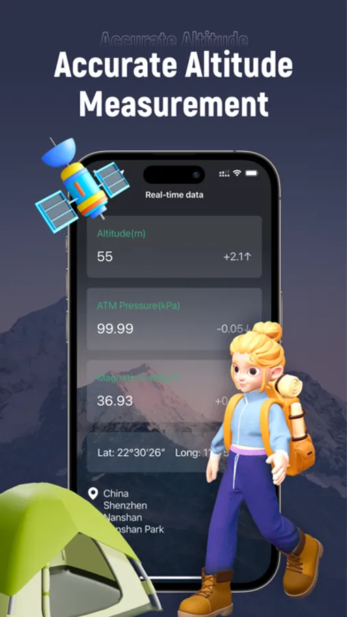
1. **Precise Altitude Measurement**
* Real-time Altitude Monitoring: Uses device sensors to measure current altitude in real time.
* Multi-unit Switching: Supports free switching between meters/feet to suit different preferences.
* Accuracy Display: Shows measurement accuracy and GPS coordinates in real time.
* Status Recognition: Intelligently identifies altitude status (Low/Medium/High/Extreme Altitude).
2. **Professional Data Analysis**
* Historical Charts: Visualize altitude trends with support for time-range filtering.
* Data Statistics: Automatically calculates key metrics like min, max, and average values.
* Data Export: Supports CSV/JSON export for professional analysis.
* Data Sharing: Instantly generates beautiful data cards to share with friends or teams.
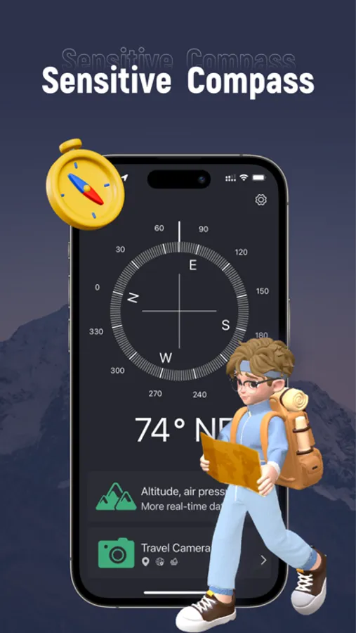
3. **Integrated Compass**
* Accurate Bearing: Displays precise bearing angle and direction in real time.
* Coordinate Display: Shows current GPS coordinates (latitude/longitude) simultaneously.
* Calibration Tool: Built-in professional calibration tool ensures compass accuracy.
**Professional Feature Details**
1. **Data Management**
* History Log: Automatically saves all measurement data (up to 10,000 records).
* Smart Filtering: Filter data by time range (1 hour/24 hours/7 days/30 days).
* Data Cleanup: Supports batch cleanup of history to free storage.
* Import/Export: Seamless data exchange with desktop software.
2. **Customizable Settings**
* Multiple chart line styles (Straight/Curve/Step/Dashed).
* Customizable chart color themes and line thickness.
* Adjustable chart data point size and density.
* Altitude Unit: Free switching between meters/feet.
3. **Smart Alert System**
* Altitude Alerts: Get notified upon reaching a specific altitude.
* Change Alerts: Monitors rapid altitude changes and sends notifications.
* Custom Conditions: Supports multi-condition combined alerts.
* Background Operation: Continuously monitors and alerts even while in the background.
* Local Notifications: Receive alerts even offline.
4. **Data Sharing**
* Share real-time altitude data cards.
* Share historical data tables.
* Share statistical chart images.
**Use Cases**
1. **Outdoor Adventure**
* Mountain climbing height records and route planning.
* Hiking altitude change monitoring.
* Altitude sickness prevention and early warning.
* Campsite elevation assessment.
2. **Engineering & Surveying**
* Building height measurement and recording.
* Topographic survey data collection.
* Construction process height monitoring.
* Project progress elevation verification.
3. **Education & Research**
* Geography class teaching aid.
* Scientific research data collection and analysis.
* Environmental change altitude monitoring.
* Student outdoor practice tool.
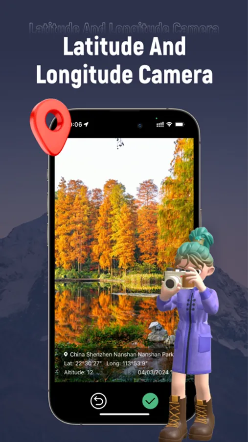
4. **Travel Logging**
* Record altitude changes during travel.
* Travel photos with altitude watermarks.
* Trip height change statistics.
5. **Data Security**
* Local data storage protects privacy.
* Data encrypted storage.
* No mandatory network permissions required.
Download Altitude Pro now and begin your high-precision measurement journey!
Privacy Policy: https://compassnow.github.io/privacy.html
Terms of use: https://compassnow.github.io/terms.html
Altitude is a powerful professional altitude measurement app that integrates precise altitude measurement, a smart compass, and a watermark camera. Whether you're a mountaineering enthusiast, outdoor explorer, construction engineer, or geographer, this app provides you with accurate and reliable elevation data and practical tools.
**Core Features**
1. **Precise Altitude Measurement**
* Real-time Altitude Monitoring: Uses device sensors to measure current altitude in real time.
* Multi-unit Switching: Supports free switching between meters/feet to suit different preferences.
* Accuracy Display: Shows measurement accuracy and GPS coordinates in real time.
* Status Recognition: Intelligently identifies altitude status (Low/Medium/High/Extreme Altitude).
2. **Professional Data Analysis**
* Historical Charts: Visualize altitude trends with support for time-range filtering.
* Data Statistics: Automatically calculates key metrics like min, max, and average values.
* Data Export: Supports CSV/JSON export for professional analysis.
* Data Sharing: Instantly generates beautiful data cards to share with friends or teams.
3. **Integrated Compass**
* Accurate Bearing: Displays precise bearing angle and direction in real time.
* Coordinate Display: Shows current GPS coordinates (latitude/longitude) simultaneously.
* Calibration Tool: Built-in professional calibration tool ensures compass accuracy.
**Professional Feature Details**
1. **Data Management**
* History Log: Automatically saves all measurement data (up to 10,000 records).
* Smart Filtering: Filter data by time range (1 hour/24 hours/7 days/30 days).
* Data Cleanup: Supports batch cleanup of history to free storage.
* Import/Export: Seamless data exchange with desktop software.
2. **Customizable Settings**
* Multiple chart line styles (Straight/Curve/Step/Dashed).
* Customizable chart color themes and line thickness.
* Adjustable chart data point size and density.
* Altitude Unit: Free switching between meters/feet.
3. **Smart Alert System**
* Altitude Alerts: Get notified upon reaching a specific altitude.
* Change Alerts: Monitors rapid altitude changes and sends notifications.
* Custom Conditions: Supports multi-condition combined alerts.
* Background Operation: Continuously monitors and alerts even while in the background.
* Local Notifications: Receive alerts even offline.
4. **Data Sharing**
* Share real-time altitude data cards.
* Share historical data tables.
* Share statistical chart images.
**Use Cases**
1. **Outdoor Adventure**
* Mountain climbing height records and route planning.
* Hiking altitude change monitoring.
* Altitude sickness prevention and early warning.
* Campsite elevation assessment.
2. **Engineering & Surveying**
* Building height measurement and recording.
* Topographic survey data collection.
* Construction process height monitoring.
* Project progress elevation verification.
3. **Education & Research**
* Geography class teaching aid.
* Scientific research data collection and analysis.
* Environmental change altitude monitoring.
* Student outdoor practice tool.
4. **Travel Logging**
* Record altitude changes during travel.
* Travel photos with altitude watermarks.
* Trip height change statistics.
5. **Data Security**
* Local data storage protects privacy.
* Data encrypted storage.
* No mandatory network permissions required.
Download Altitude Pro now and begin your high-precision measurement journey!
Privacy Policy: https://compassnow.github.io/privacy.html
Terms of use: https://compassnow.github.io/terms.html
My Altitude: Chart & Compass Screenshots
Tap to Rate: