In this mapping app, you can download and view topographic maps of the United States, access different map sources, and use GPS tracking features. Includes offline map access, waypoint management, trail import and sharing, and trail recording functionalities.
AppRecs review analysis
AppRecs rating 4.5. Trustworthiness 73 out of 100. Review manipulation risk 25 out of 100. Based on a review sample analyzed.
★★★★☆
4.5
AppRecs Rating
Ratings breakdown
5 star
75%
4 star
12%
3 star
2%
2 star
3%
1 star
9%
What to know
✓
Low review manipulation risk
25% review manipulation risk
✓
Credible reviews
73% trustworthiness score from analyzed reviews
✓
High user satisfaction
87% of sampled ratings are 4+ stars (4.4★ average)
About Topo Maps US
Topographic maps are useful for recreational activities such as hiking, canoeing, camping, fishing, mountain biking, geocaching, and exploring.
MAPS
Choose from 2 map sources: USGS standard topographic or USGS hybrid topographic.
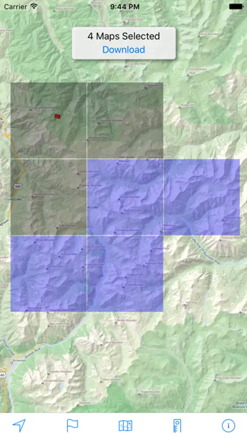
OFFLINE
Download maps for areas of interest to view them later when you don't have Internet access or you don't want to use cell data.
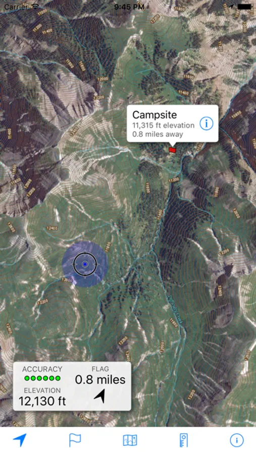
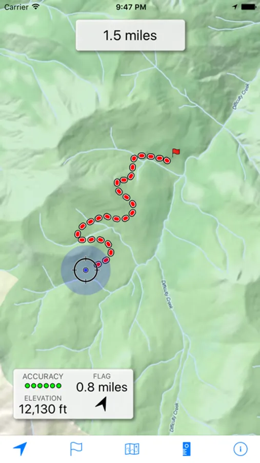
TRACKING
Use location tracking to show where you are on the map, your elevation, and the accuracy of the GPS signal.
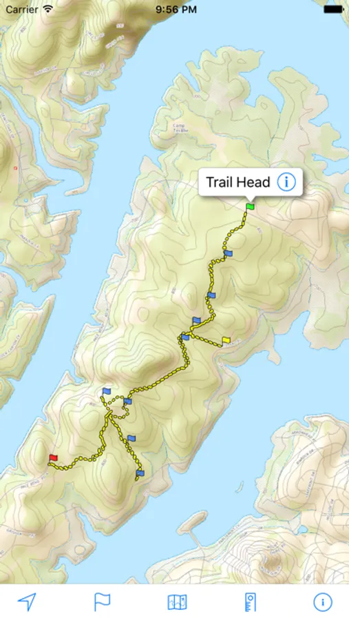
FLAGS
Flags are included with map downloads. Add flags (waypoints) to the map to mark your current location or other locations. Import flags from other sources using GPX files and geocache LOC files. Share flags with others using email or AirDrop. Organize your flag types by color, for example, geocaches, trailheads, and summits.
TRAILS
Trails are included with map downloads. Import trails (tracks) using GPX files you find on the Internet or from your personal GPS track collection. Share trails with others using email or AirDrop. Organize your trail types by color, for example, mountain bike trails, hiking trails, and OHV trails.
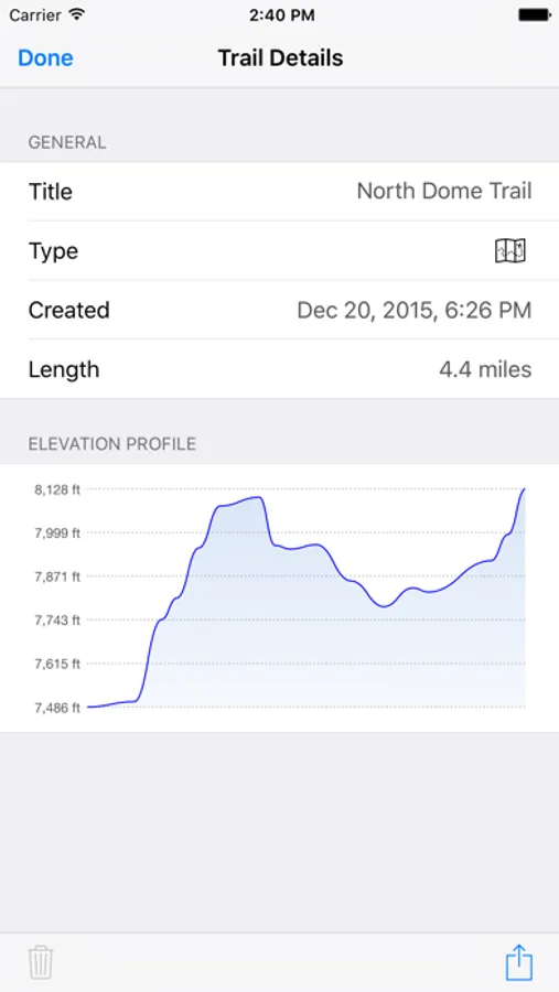
TRAIL RECORDING
Record your own trails to show where you've been on the map, follow them later, and share with others.
ELEVATION PROFILE
Recorded trails include an elevation profile (distance/elevation chart).
NAVIGATION
Navigate to a flag by following the direction arrow that uses your compass heading. Useful for geocaching.
MEASURE
Measure the distance between points on the map.
Note: Continued use of GPS running in the background can dramatically decrease battery life.
Topo Maps US Screenshots
Tap to Rate:
Reviews for Topo Maps US
zen one
MY GO-TO
This app is the best. I always carry paper maps, upload the GPXs to my watch, and gave satellite support, but this is hands down the best Topo graphic app. Simple, reliable, works offline. The interface is intuitive and never gets in the way of the task at hand. I recon this app for anyone serious about the outdoors.
cmattc
Simply Great
I’m a person that likes the simplicity of this app. Free Topo maps with gps locationing. You can save and categorize pins, use GPS coordinates, and measure distances. No subscriptions and no nagging ads. Very handy. Needs no cell reception to work assuming you downloaded your map segments in advance. Would and have recommended.