In this app, browse wildfire and prescribed burn activity worldwide, view active fire perimeters, and access satellite hotspot maps. Includes real-time fire data, recent news, weather conditions, and air quality information.
AppRecs review analysis
AppRecs rating 3.6. Trustworthiness 82 out of 100. Review manipulation risk 20 out of 100. Based on a review sample analyzed.
★★★☆☆
3.6
AppRecs Rating
Ratings breakdown
5 star
55%
4 star
0%
3 star
6%
2 star
10%
1 star
29%
What to know
✓
Low review manipulation risk
20% review manipulation risk
✓
Credible reviews
82% trustworthiness score from analyzed reviews
About Wildfire Info
Browse current wildfire and prescribed burn activity throughout all of the world.
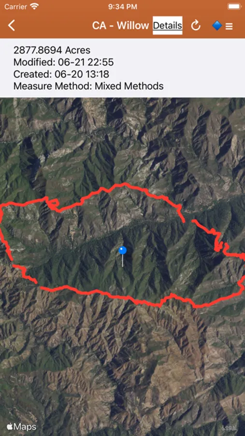
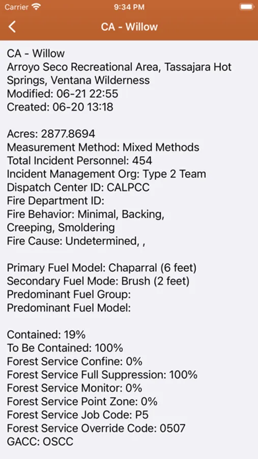
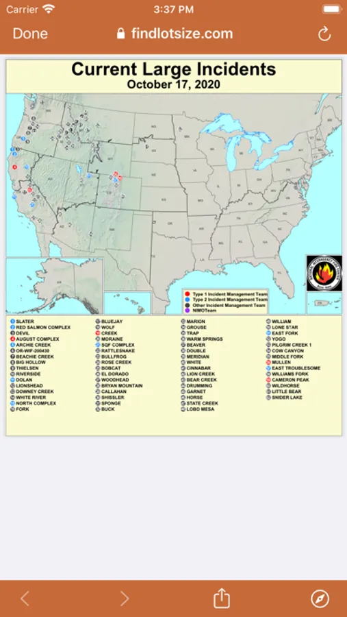
Active Wildfire Perimeter data from NIFC WFIGS. Tagged by state, search by name, and filter by acres burned. WFIGS stands for the Wildland Fire Interagency Geospatial Services (WFIGS) Group. NIFC stands for the National Interagency Fire Center. NIFC WFIGS Source URLs: https://www.nifc.gov/ with data hosted at https://data-nifc.opendata.arcgis.com/datasets/nifc::wfigs-current-interagency-fire-perimeters/about
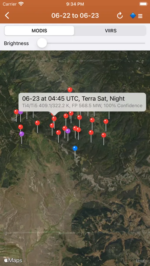
NASA MODIS and VIIRS satellite instruments data: Thermal hotspot maps by region show wildfire activity in the past 48 hours. See hotspot info including fire radiance power, brightness temperature, and confidence. NASA MODIS/VIIRS Source URL: https://firms.modaps.eosdis.nasa.gov/active_fire/ . MODIS stands for Moderate Resolution Imaging Spectroradiometer. VIIRS stands for Visible Infrared Imaging Radiometer Suite.
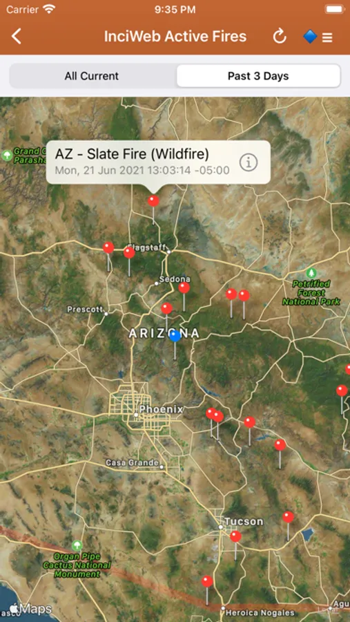
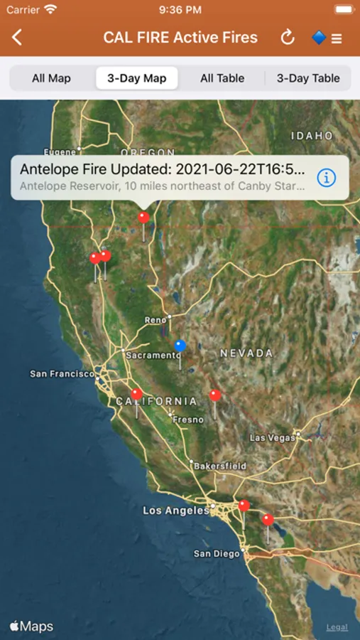
InciWeb & CAL FIRE active fire maps: hot-link to the corresponding official incident webpage. Inciweb Source URL: https://inciweb.wildfire.gov/ , CAL FIRE Source URL: https://www.fire.ca.gov/incidents
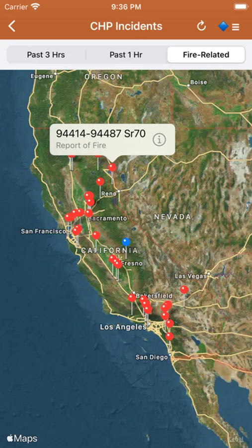
CHP (California Highway Patrol): Incidents in the past 3 hours related to fires are filtered out separately, all traffic incidents are included viewable by last 1 or 3 hours.CHP Source URL: https://cad.chp.ca.gov/Traffic.aspx
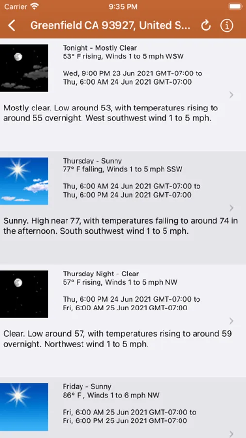
Lookup current hyper-local weather conditions, including temperature, wind and gust conditions, and local forecasts anywhere in the USA, Canada, or Australia using map quick lookup or, for USA, search: Detailed NWS Forecast, Hourly Forecast, Grid Data Forecast, and Summary Forecast. Data is from the NWS, NOAA, Government of Canada, and Government of Australia. NWS/NOAA Source URL: https://forecast.weather.gov/, Government of Canada Weather Source URL: https://weather.gc.ca/, Government of Australia Weather Source URL: http://www.bom.gov.au/
Wildfire Situation Reports section with mirrored PDFs from NIFC. NIFC Source URL: https://www.nifc.gov
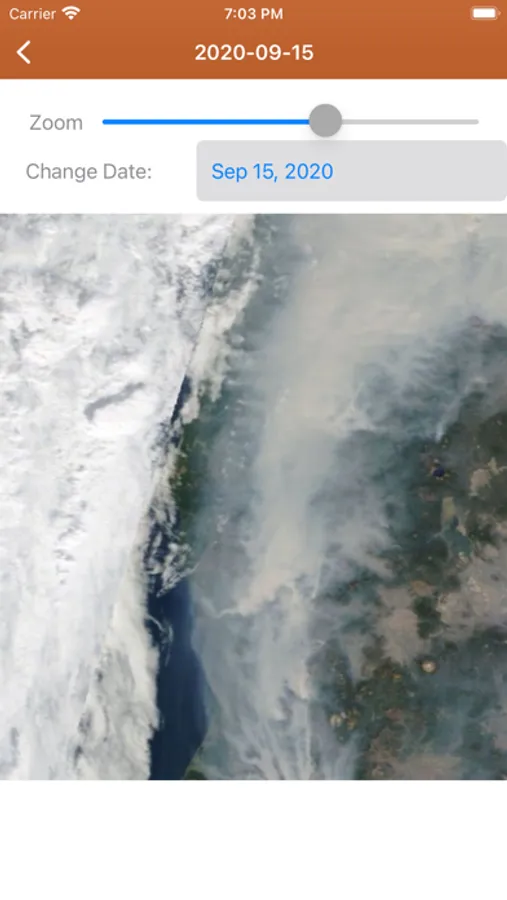
NESDIS GOES 16/17 Satellite Animations show wildfire smoke plumes, drought conditions, etc. from the satellite's perspective. NESDIS GOES Source URL: https://www.star.nesdis.noaa.gov. NESDIS stands for National Environmental Satellite, Data, and Information Service. GOES stands for
Geostationary Operational Environmental Satellite.
A Recent Wildfire News section: find news from 1,700+ cited sources quickly on a map or in a table view tagged by state alphabetically. Set up your own custom state feed with the state toggles. Quickly lookup news source homepages near specific fires.
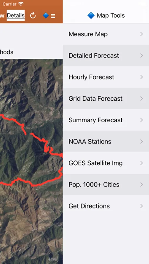
Map Measurement Tool added to the Map Tools Side Menu. Measure distance and area.
Premium users: View 250m resolution true color images from NASA GIBS (Global Imagery Browse Service). Images are available back to Jan. 1 2007. Worldwide coverage.
Premium Users: Lookup a driving route to any fire or hotspot with Google or Apple Maps directions Universal Links. Save your preferred Directions Provider in the App Settings.
There is a section for wildfire-related US government Twitter accounts viewable by map by approximate location or sorted into national and state sources in a table view. Twitter Source URLs: https://twitter.com
User-Submitted Fire Map feature: map-based wildfire-related chatter. Photos are allowed. Posts and replies are anonymous; no account needed.
Information is posted as soon as it becomes available from WFIGS, NIFC, NASA, InciWeb, CAL FIRE, CHP, NESDIS, NOAA, NWS, Government of Canada, and Government of Australia.
This app is not affiliated with any government agency.
Terms of Use: https://davidgrossapps.com/terms/tos-wildfire-info.html
Privacy Policy: https://davidgrossapps.com/privacy-policy.html
Wildfire Info Screenshots
Tap to Rate:
Reviews for Wildfire Info
BlazeJester
Old app needs updated
Interface is basic and old school. Needs a redesign to stay modern. Since other much more modern and frequently updated apps with the same functionality always exist, it’s better to avoid this one - it’s not supported and should probably be retired.
kcopter
Wildfire info
Still getting run time errors it never lasted this long I guess it’s time to move on and delete it will be using watch duty for fire info now. This has not been updated for over 3 years not good.