AppRecs review analysis
AppRecs rating 4.3. Trustworthiness 84 out of 100. Review manipulation risk 17 out of 100. Based on a review sample analyzed.
★★★★☆
4.3
AppRecs Rating
Ratings breakdown
5 star
67%
4 star
8%
3 star
13%
2 star
8%
1 star
4%
What to know
✓
Low review manipulation risk
17% review manipulation risk
✓
Credible reviews
84% trustworthiness score from analyzed reviews
✓
High user satisfaction
75% of sampled ratings are 4+ stars (4.3★ average)
About BRMB Maps by Backroad Maps
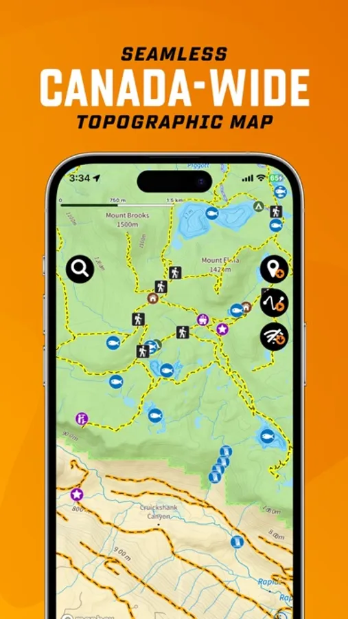
Explore Canada’s outdoors with confidence using BRMB Maps, the most detailed and trusted GPS navigation app for the backcountry. Built from the award-winning Backroad Mapbooks series, BRMB Maps combines detailed topographic maps with over 900,000 searchable Points of Interest across every province and territory.
Whether fishing, camping, hiking, hunting, paddling, ATVing, snowmobiling or wildlife viewing, BRMB Maps has everything you need to plan, navigate and explore – online or offline.
Key Features
-Topographic GPS Maps – View relief shading, contour lines, backroads, parks and geographic features
-Current Location Tracking – Use your phone’s GPS to navigate in real time
-Cross-Device Access – Use on smartphone, tablet and desktop with a single account
-Canada-Wide Basemap – Includes a seamless Backroad Maps basemap across Canada
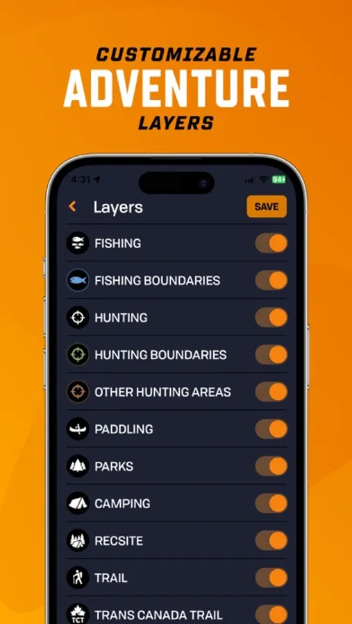
-Custom Adventure Layers (PRO) – Enable fishing, hunting, trails, paddling, Crown land & more
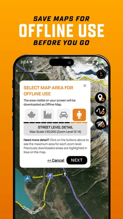
-Offline Maps (PRO) – Download maps and all POI details for off-grid navigation
-Satellite Imagery (PRO) – Overlay roads, trails and features on high-res satellite maps
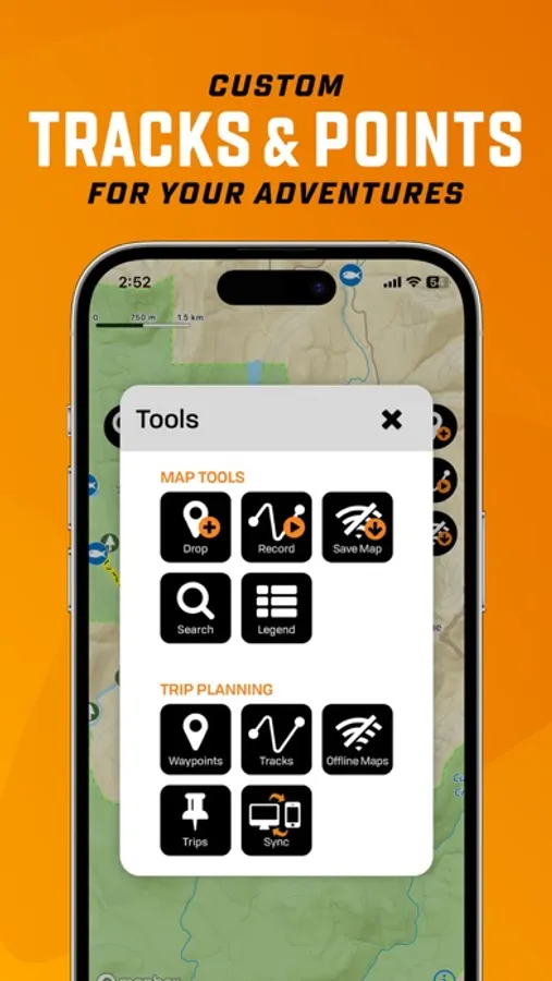
-Trip Recording & Custom Waypoints – Track routes, mark campsites and save locations
-Printable Custom Maps (PRO) – Create and print stunning maps from brmbmaps.com
Explore Over 150,000 Adventures
Fishing
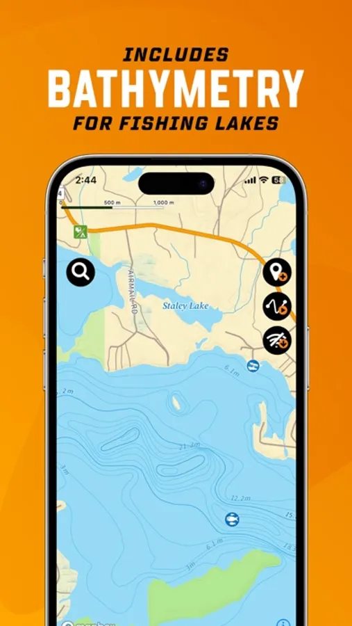
-22,000+ lakes, rivers, creeks & ocean fishing areas
-Bathymetry (lake & ocean depths), fish species, stocked lakes, boat launches & marinas
-Boundaries & regulations
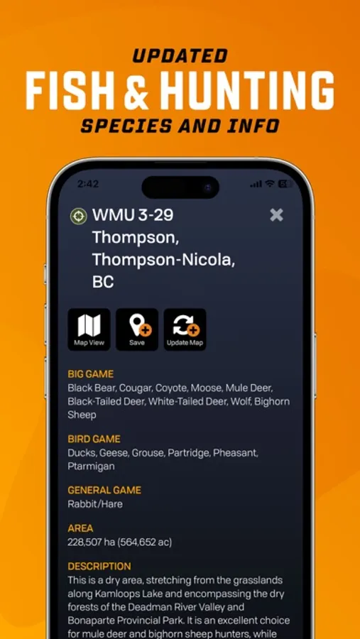
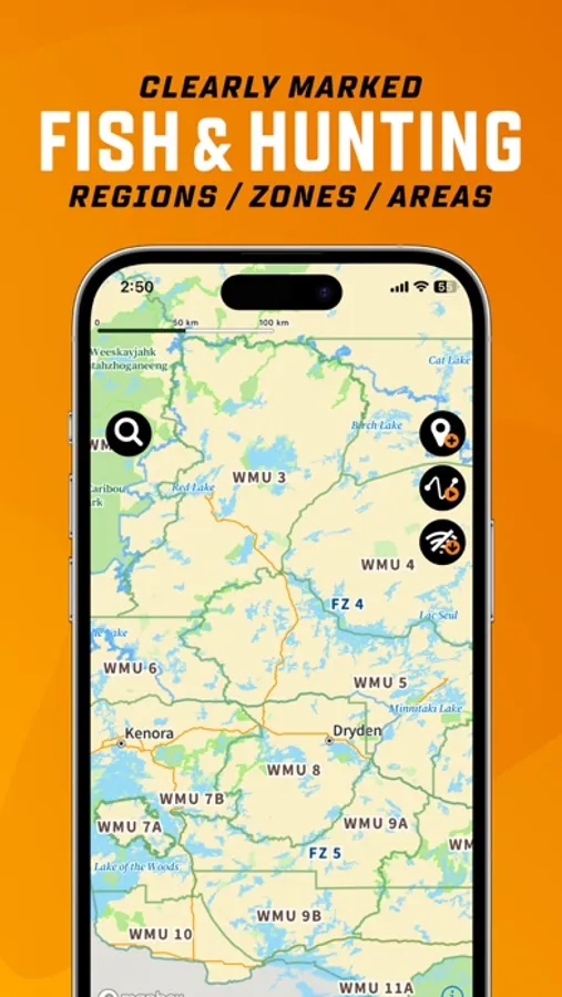
Hunting
-3,500+ hunting areas (WMU, WMZ, species-specific zones)
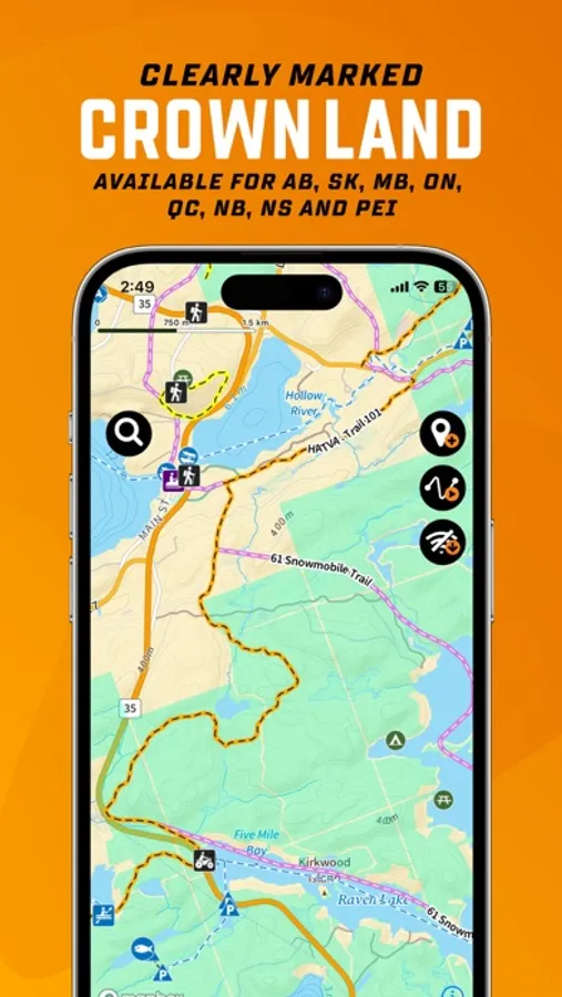
-Species details, boundaries & regulations
-Crown land & private land layers
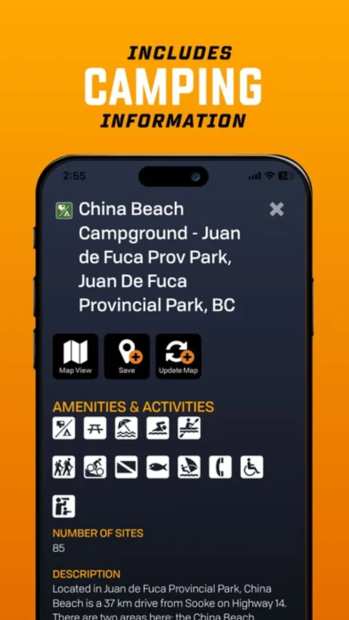
Camping & Parks
-20,000 national, provincial, regional, urban and natural parks
-Campsites, picnic areas, backcountry campsites, huts & cabins
-Private campgrounds, resorts & lodges, amenities & services
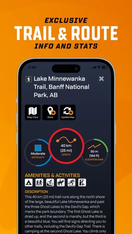
Hiking, Biking & Horseback Trails
-130,000+ km of multi-use trails with trailheads, difficulty, distance & elevation gain
-Includes hiking, mountain biking, horseback riding, backpacking and multi-use
-Separate Trans-Canada Trail layer with trailheads, pavilions and alternate routes
Paddling (Canoeing & Kayaking)
-107,000+ km of routes with access points, difficulty, distance & grading
-Features lake circuits, river and ocean paddling routes, whitewater & more
-Paddling routes include portages with distances, campsites, put-ins & take-outs
ATV, OHV, Off-Road and Overland Routes
-160,000+ km of trails and routes with staging areas, difficulty & distance
-Features ATV/OHV, dirt biking and overlanding routes
-Plus 3,000,000+ km of Roads and 160,000+ km of Logging Roads to explore
Snowmobiling
-150,000+ km of trails and routes with staging areas, difficulty & distance
-Features federation & club-maintained trails, plus backcountry routes
-Clubhouses, warming huts & shelters, side trails and more
Winter Recreation
-9,500+ km of ski & snowshoe trails for cross-country, Nordic, backcountry & downhill skiing
-2,100+ trailheads, Nordic areas & ski centres
-Trails feature difficulty, distance, elevation gain & ski area amenities
Wildlife Viewing & Nature
-1,800+ sites for birdwatching & wildlife viewing
-Features birding sites, fish hatcheries, marine life, small & large animals
-Bird viewing & scenic lookouts, trailheads & wildlife centres
Attractions & Unique Sites
-20,000+ points, including roadside and backroad attractions
-Features big trees, caves, waterfalls, hot springs, lighthouses, beaches, museums and scenic areas
-Hours, location and contact information
Why BRMB Maps?
Unlike other GPS apps, BRMB Maps is built specifically for Canadian terrain and adventures, with unmatched detail, local insights and recreation-focused layers. Start exploring Canada’s wild spaces with BRMB Maps – your GPS trail map, hunting app, fishing tool and trip planner all in one.
Download BRMB Maps today and experience Canada's most complete outdoor mapping app.
BRMB Maps by Backroad Maps Screenshots
Tap to Rate:
Reviews for BRMB Maps by Backroad Maps
Mattkrea
No better app for exploring Canada
Absolutely everything you could possibly want for exploring anywhere in Canada. If you’re familiar with the US public land layers in Gaia (USFS sites, NF land), you’ll see similar things like Rec Sites and Crown Land here. AND the team actually replies to feedback unlike other companies out there.
Mighty Gord
Americans Don’t Use This
I live in Texas and when I loaded up the app, nothing showed. Nothing showed for the entire United States. The only area that had any detail was Canada. So if you live in the US there is not point in getting this app.