FltPlan Go for iPhone
FltPlan.com (Flight Plan LLC)
4.0 ★
145 ratings
Free
In this app, users can create, sync, and edit flight plans and NavLogs for in-flight use. Includes airport information, weather updates, maps with approach overlays, and offline navigation tools.
AppRecs review analysis
AppRecs rating 3.8. Trustworthiness 82 out of 100. Review manipulation risk 20 out of 100. Based on a review sample analyzed.
★★★☆☆
3.8
AppRecs Rating
Ratings breakdown
5 star
54%
4 star
19%
3 star
10%
2 star
6%
1 star
10%
What to know
✓
Low review manipulation risk
20% review manipulation risk
✓
Credible reviews
82% trustworthiness score from analyzed reviews
✓
High user satisfaction
73% of sampled ratings are 4+ stars (4.0★ average)
About FltPlan Go for iPhone
• Create and file your flight plan on FltPlan.com, and it will sync to FltPlan Go to allow you to responsively edit the flight plan on the map
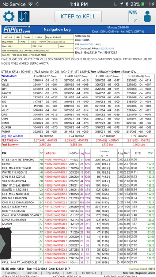
• NavLogs are automatically synced and downloaded for offline use
• Create and file your flight plan on FltPlan Go to sync to FltPlan.com
FltPlan Go delivers powerful routing, weather, mapping features, and comprehensive aviation information including:
AIRPORTS:
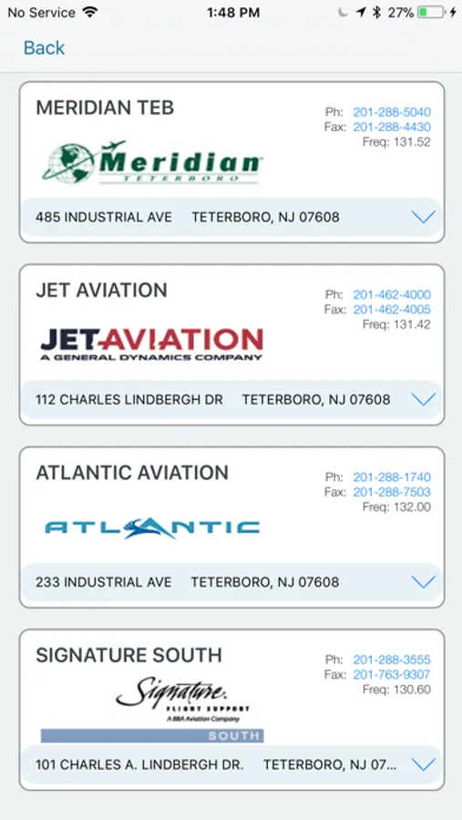
• Airport & FBO Information including current fuel prices
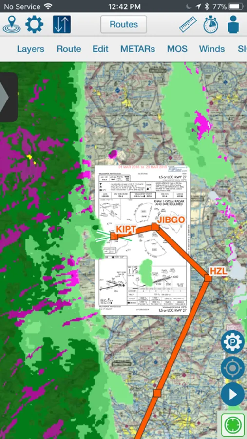
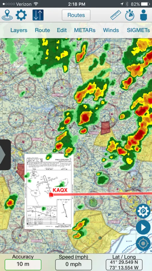
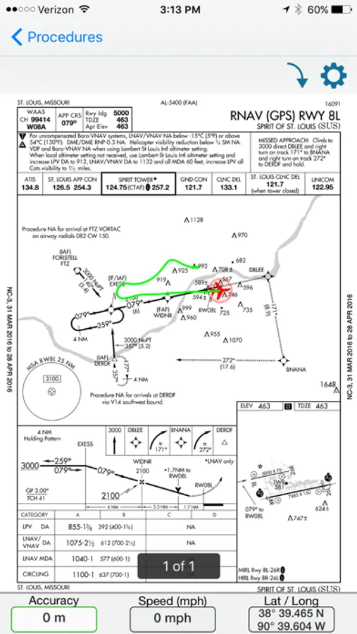
• Geo-Referenced approach plates & airport diagrams (U.S & Canada)
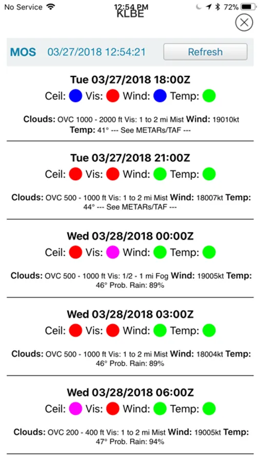
• Weather, including METARs, TAFs, PIREPs, & MOS
• NOTAMs & Remarks
MAPS:
• Sync FltPlan.com flight plans and interactively edit on the map
• File a flight plan from within FltPlan Go
• Moving maps with sectionals, enroute charts, & more
• Overlay approach plates & procedures on the map
• Layers including SUAs, TFRs, State Outline, Airports, Fuel Prices, CAP Grid, Stadiums, and Customs
• Display METARs, Winds, SIGMETs, and animated Weather on the map
• Display MOS weather forecasts (up to 4 days out) on the map
• Breadcrumbs with enhanced playback & option to open in Google Earth
• Display Search & Rescue patterns
• Course Deviation Indicator (CDI)
• Create or import Custom Waypoints in KML or CSV format
• Overlay in-flight ADS-B traffic & weather or XM Weather*
NAVLOGS:
• NavLogs automatically sync and download for offline use
• Email or print NavLogs from within FltPlan Go
ADDITIONAL FEATURES:
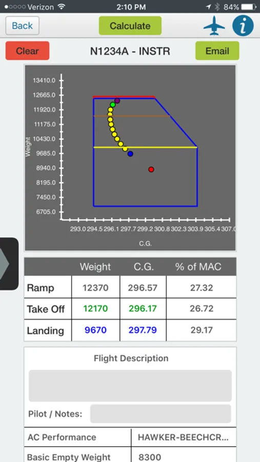
• Weight & Balance - create computations with the option to email
• eLogbook - create logbook entries to sync to our eLogbook program
• Checklists - synced from FltPlan.com for your specific aircraft
• Binders - create flight specific binders with documents or procedures, airports, NavLogs, weather briefs, & more
• Weather - search airport or route weather
• Tracking - view live tracking
• PDCs
• Cloud Tops
• Aviation Calculators
• Access to FltPlan.com
EXTERNAL:
AVIONICS
• Garmin
• Dynon SkyView
• Advanced Flight Systems
• Avidyne IFD Series
• DAC International GDC64
ADS-B
• Garmin
• Stratus 3
• Dual XGPS 170/190
• Dynon D2
• FreeFlight
• Pathfinder
• iLevil SW
• L-3 Lynx
• SkyGuard
• Stratux
• FlightBox
• pingBuddy
• Clarity
• Custom Unit
GPS
• Garmin GDL 51 & GLO
• Dual XGPS 150
• Bad Elf
APP-TO-APP
• Garmin Pilot
• Satcom Direct
• Jeppesen Mobile FD 2.7
SIMULATORS
• X-Plane Simulator
• FSX & Prepar3D
*Subscription/Unit Required
*Continued use of GPS running in the background can dramatically decrease battery life.
FltPlan has grown into the largest flight planning company in North America. FltPlan covers the U.S., Canada, Mexico, Central America, the Caribbean, Panama, and parts of Venezuela and Columbia. FltPlan’s 165,000-plus active, registered users file more than 55% of all N#-registered flight plans. FltPlan Go is a part of FltPlan's comprehensive system that includes free, web-based flight planning and filing and a full range of premium services. FltPlan has more than 18 years of general aviation experience, giving pilots access to the best support team in the business.
24/7 FltPlan Go support is available at Tech@FltPlan.com
FltPlan Go for iPhone Screenshots
Tap to Rate:
Reviews for FltPlan Go for iPhone
Hapadopoulos
Saftey
Update: thank you for fixing. But after the extended time, i bought non garmin offerings. ——- Abandoned app Broken safety features that makes it dangerous for pilots No updates in over 10 months Don’t install
ChaseRU2
Bye Bye FREE
Since Garmin got their greedy hands on this once wonderful, free app, it's only a matter of time before they eother shut it down or start charging an arm & leg for it. Typical business practice for Garmin. Ex. in order to force their loyal customers to buy their new GTNs, they stop supporting the 430/530s. Criminal imo.